Laroquevieille (Laroquevieille)

- commune in Cantal, France
- Country:

- Postal Code: 15250
- Coordinates: 45° 1' 13" N, 2° 31' 45" E


- GPS tracks (wikiloc): [Link]
- AboveSeaLevel: 720 м m
- Area: 15.68 sq km
- Population: 345
- Wikipedia en: wiki(en)
- Wikipedia: wiki(fr)
- Wikidata storage: Wikidata: Q672342
- Wikipedia Commons Category: [Link]
- Freebase ID: [/m/03mb7p7]
- GeoNames ID: Alt: [6615941]
- SIREN number: [211500954]
- BnF ID: [152482653]
- VIAF ID: Alt: [243550280]
- INSEE municipality code: 15095
Shares border with regions:


Marmanhac
- commune in Cantal, France
- Country:
- Postal Code: 15250
- Coordinates: 45° 0' 13" N, 2° 28' 56" E
- GPS tracks (wikiloc): [Link]
- Area: 24.24 sq km
- Population: 712

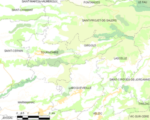
Girgols
- commune in Cantal, France
- Country:
- Postal Code: 15310
- Coordinates: 45° 2' 18" N, 2° 28' 53" E
- GPS tracks (wikiloc): [Link]
- Area: 12.62 sq km
- Population: 77

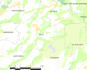
Velzic
- commune in Cantal, France
- Country:
- Postal Code: 15590
- Coordinates: 45° 0' 3" N, 2° 33' 10" E
- GPS tracks (wikiloc): [Link]
- Area: 11.26 sq km
- Population: 422


Lascelle
- commune in Cantal, France
- Country:
- Postal Code: 15590
- Coordinates: 45° 1' 22" N, 2° 34' 32" E
- GPS tracks (wikiloc): [Link]
- Area: 19.1 sq km
- Population: 300