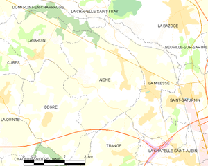
Lavardin (Lavardin)

- commune in Sarthe, France
- Country:

- Postal Code: 72240
- Coordinates: 48° 4' 40" N, 0° 3' 43" E


- GPS tracks (wikiloc): [Link]
- Area: 7.63 sq km
- Population: 741
- Web site: http://lavardin.e-monsite.com
- Wikipedia en: wiki(en)
- Wikipedia: wiki(fr)
- Wikidata storage: Wikidata: Q905556
- Wikipedia Commons Category: [Link]
- Freebase ID: [/m/03qk2g_]
- GeoNames ID: Alt: [6454640]
- SIREN number: [217201573]
- BnF ID: [152737129]
- INSEE municipality code: 72157
Shares border with regions:


Degré
- commune in Sarthe, France
- Country:
- Postal Code: 72550
- Coordinates: 48° 3' 1" N, 0° 4' 5" E
- GPS tracks (wikiloc): [Link]
- Area: 9.83 sq km
- Population: 797
- Web site: [Link]

Aigné
- commune in Sarthe, France
- Country:
- Postal Code: 72650
- Coordinates: 48° 4' 1" N, 0° 7' 8" E
- GPS tracks (wikiloc): [Link]
- Area: 12.59 sq km
- Population: 1627
- Web site: [Link]


Domfront-en-Champagne
- commune in Sarthe, France
- Country:
- Postal Code: 72240
- Coordinates: 48° 6' 17" N, 0° 1' 41" E
- GPS tracks (wikiloc): [Link]
- Area: 20.97 sq km
- Population: 1020

Cures, Sarthe
- commune in Sarthe, France
- Country:
- Postal Code: 72240
- Coordinates: 48° 6' 1" N, 0° 0' 18" E
- GPS tracks (wikiloc): [Link]
- Area: 11.5 sq km
- Population: 503
- Web site: [Link]