Le Bouillon (Le Bouillon)

- commune in Orne, France
- Country:

- Postal Code: 61500
- Coordinates: 48° 33' 42" N, 0° 6' 12" E


- GPS tracks (wikiloc): [Link]
- Area: 17.77 sq km
- Population: 173
- Wikipedia en: wiki(en)
- Wikipedia: wiki(fr)
- Wikidata storage: Wikidata: Q181397
- Wikipedia Commons Category: [Link]
- Freebase ID: [/m/03qgqj7]
- Freebase ID: [/m/03qgqj7]
- GeoNames ID: Alt: [6614816]
- GeoNames ID: Alt: [6614816]
- SIREN number: [216100560]
- SIREN number: [216100560]
- BnF ID: [15267991r]
- BnF ID: [15267991r]
- INSEE municipality code: 61056
- INSEE municipality code: 61056
Shares border with regions:

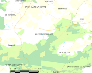
La Ferrière-Béchet
- commune in Orne, France
- Country:
- Postal Code: 61500
- Coordinates: 48° 34' 47" N, 0° 4' 18" E
- GPS tracks (wikiloc): [Link]
- Area: 13.79 sq km
- Population: 239

Fontenai-les-Louvets
- commune in Orne, France
- Country:
- Postal Code: 61420
- Coordinates: 48° 31' 38" N, 0° 0' 7" E
- GPS tracks (wikiloc): [Link]
- AboveSeaLevel: 304 м m
- Area: 18.77 sq km
- Population: 253


Radon
- former commune in Orne, France
- Country:
- Postal Code: 61250
- Coordinates: 48° 30' 11" N, 0° 6' 6" E
- GPS tracks (wikiloc): [Link]
- Area: 19.81 sq km
- Population: 1052
- Web site: [Link]
Vingt-Hanaps
- former commune in Orne, France
- Country:
- Postal Code: 61250
- Coordinates: 48° 31' 22" N, 0° 8' 15" E
- GPS tracks (wikiloc): [Link]
- Area: 11.58 sq km
- Population: 451

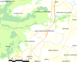
Saint-Gervais-du-Perron
- commune in Orne, France
- Country:
- Postal Code: 61500
- Coordinates: 48° 31' 58" N, 0° 9' 35" E
- GPS tracks (wikiloc): [Link]
- Area: 11.28 sq km
- Population: 386


La Chapelle-près-Sées
- commune in Orne, France
- Country:
- Postal Code: 61500
- Coordinates: 48° 34' 14" N, 0° 9' 42" E
- GPS tracks (wikiloc): [Link]
- Area: 9.95 sq km
- Population: 461


Sées
- commune in Orne, France
- Country:
- Postal Code: 61500
- Coordinates: 48° 36' 17" N, 0° 10' 17" E
- GPS tracks (wikiloc): [Link]
- AboveSeaLevel: 188 м m
- Area: 40.31 sq km
- Population: 4209
- Web site: [Link]