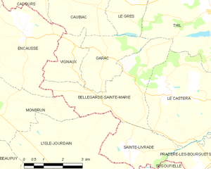
Le Castéra (Le Castéra)
- commune in Haute-Garonne, France
- Country:

- Postal Code: 31530
- Coordinates: 43° 40' 20" N, 1° 8' 15" E


- GPS tracks (wikiloc): [Link]
- Area: 16.71 sq km
- Population: 778
- Web site: http://www.mairie-lecastera31.fr
- Wikipedia en: wiki(en)
- Wikipedia: wiki(fr)
- Wikidata storage: Wikidata: Q1419188
- Wikipedia Commons Category: [Link]
- Freebase ID: [/m/03nsytf]
- Freebase ID: [/m/03nsytf]
- SIREN number: [213101207]
- SIREN number: [213101207]
- BnF ID: [152551163]
- BnF ID: [152551163]
- PACTOLS thesaurus ID: [pcrtmbGGqnmIbQ]
- PACTOLS thesaurus ID: [pcrtmbGGqnmIbQ]
- INSEE municipality code: 31120
- INSEE municipality code: 31120
Shares border with regions:
Pradère-les-Bourguets
- former commune in Haute-Garonne, France
- Country:

- Postal Code: 31530
- Coordinates: 43° 38' 27" N, 1° 9' 58" E


- GPS tracks (wikiloc): [Link]
- Area: 4.89 sq km
- Population: 441
- Web site: [Link]
Sainte-Livrade
- commune in Haute-Garonne, France
- Country:

- Postal Code: 31530
- Coordinates: 43° 39' 0" N, 1° 6' 16" E


- GPS tracks (wikiloc): [Link]
- Area: 6.16 sq km
- Population: 292
- Web site: [Link]


Lévignac
- commune in Haute-Garonne, France
- Country:

- Postal Code: 31530
- Coordinates: 43° 39' 57" N, 1° 11' 40" E


- GPS tracks (wikiloc): [Link]
- Area: 12.22 sq km
- Population: 2022
- Web site: [Link]
Menville
- commune in Haute-Garonne, France
- Country:

- Postal Code: 31530
- Coordinates: 43° 40' 39" N, 1° 11' 38" E


- GPS tracks (wikiloc): [Link]
- Area: 5.07 sq km
- Population: 729


Bellegarde-Sainte-Marie
- commune in Haute-Garonne, France
- Country:

- Postal Code: 31530
- Coordinates: 43° 41' 0" N, 1° 7' 0" E


- GPS tracks (wikiloc): [Link]
- AboveSeaLevel: 230 м m
- Area: 11.66 sq km
- Population: 200
Thil
- commune in Haute-Garonne, France
- Country:

- Postal Code: 31530
- Coordinates: 43° 42' 44" N, 1° 9' 38" E


- GPS tracks (wikiloc): [Link]
- Area: 23.68 sq km
- Population: 1183
- Web site: [Link]
