Le Cellier (Le Cellier)

- commune in Loire-Atlantique, France
- Country:

- Postal Code: 44850
- Coordinates: 47° 19' 10" N, 1° 20' 47" E


- GPS tracks (wikiloc): [Link]
- Area: 35.99 sq km
- Population: 3666
- Web site: http://www.lecellier.fr
- Wikipedia en: wiki(en)
- Wikipedia: wiki(fr)
- Wikidata storage: Wikidata: Q664678
- Wikipedia Commons Category: [Link]
- Freebase ID: [/m/03nwcjc]
- Freebase ID: [/m/03nwcjc]
- GeoNames ID: Alt: [3004813]
- GeoNames ID: Alt: [3004813]
- SIREN number: [214400285]
- SIREN number: [214400285]
- BnF ID: [15260197x]
- BnF ID: [15260197x]
- VIAF ID: Alt: [249410066]
- VIAF ID: Alt: [249410066]
- GND ID: Alt: [4694806-5]
- GND ID: Alt: [4694806-5]
- archINFORM location ID: [4194]
- archINFORM location ID: [4194]
- WOEID: [602469]
- WOEID: [602469]
- INSEE municipality code: 44028
- INSEE municipality code: 44028
Shares border with regions:


Saint-Mars-du-Désert
- commune in Loire-Atlantique, France
- Country:
- Postal Code: 44850
- Coordinates: 47° 21' 59" N, 1° 24' 21" E
- GPS tracks (wikiloc): [Link]
- Area: 30.46 sq km
- Population: 4721
- Web site: [Link]

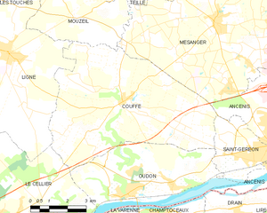
Couffé
- commune in Loire-Atlantique, France
- Country:
- Postal Code: 44521
- Coordinates: 47° 23' 29" N, 1° 17' 34" E
- GPS tracks (wikiloc): [Link]
- Area: 39.97 sq km
- Population: 2518
- Web site: [Link]


Ligné
- commune in Loire-Atlantique, France
- Country:
- Postal Code: 44850
- Coordinates: 47° 24' 42" N, 1° 22' 38" E
- GPS tracks (wikiloc): [Link]
- Area: 45.41 sq km
- Population: 5088
- Web site: [Link]

Mauves-sur-Loire
- commune in Loire-Atlantique, France
- Country:
- Postal Code: 44470
- Coordinates: 47° 17' 46" N, 1° 23' 36" E
- GPS tracks (wikiloc): [Link]
- Area: 14.75 sq km
- Population: 3200
- Web site: [Link]


Oudon
- commune in Loire-Atlantique, France
- Country:
- Postal Code: 44521
- Coordinates: 47° 20' 47" N, 1° 17' 13" E
- GPS tracks (wikiloc): [Link]
- Area: 22.12 sq km
- Population: 3720
- Web site: [Link]


La Varenne
- former commune in Maine-et-Loire, France
- Country:
- Postal Code: 49270
- Coordinates: 47° 18' 46" N, 1° 19' 19" E
- GPS tracks (wikiloc): [Link]
- Area: 14.35 sq km
- Population: 1744
- Web site: [Link]