Le Déluge (Le Déluge)

- former commune in Oise, France
- Country:

- Postal Code: 60790
- Coordinates: 49° 17' 49" N, 2° 6' 36" E


- GPS tracks (wikiloc): [Link]
- Area: 3.69 sq km
- Population: 525
- Wikipedia en: wiki(en)
- Wikipedia: wiki(fr)
- Wikidata storage: Wikidata: Q1161363
- Wikipedia Commons Category: [Link]
- Freebase ID: [/m/03qg7fm]
- GeoNames ID: Alt: [6456243]
- INSEE municipality code: 60196
Shares border with regions:

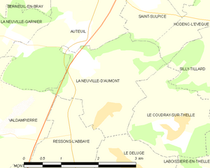
La Neuville-d'Aumont
- former commune in Oise, France
- Country:
- Postal Code: 60790
- Coordinates: 49° 18' 34" N, 2° 5' 56" E
- GPS tracks (wikiloc): [Link]
- Area: 4.75 sq km
- Population: 331
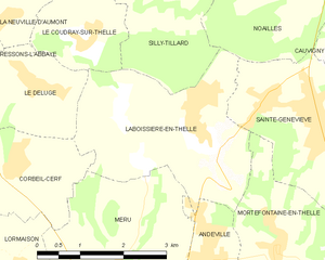
Laboissière-en-Thelle
- commune in Oise, France
- Country:
- Postal Code: 60570
- Coordinates: 49° 17' 23" N, 2° 9' 30" E
- GPS tracks (wikiloc): [Link]
- Area: 9.64 sq km
- Population: 1312


Corbeil-Cerf
- commune in Oise, France
- Country:
- Postal Code: 60110
- Coordinates: 49° 16' 47" N, 2° 6' 13" E
- GPS tracks (wikiloc): [Link]
- Area: 3.95 sq km
- Population: 356

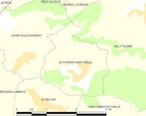
Le Coudray-sur-Thelle
- commune in Oise, France
- Country:
- Postal Code: 60430
- Coordinates: 49° 18' 21" N, 2° 7' 26" E
- GPS tracks (wikiloc): [Link]
- Area: 3.76 sq km
- Population: 534


Ressons-l'Abbaye
- former commune in Oise, France
- Country:
- Postal Code: 60790
- Coordinates: 49° 18' 8" N, 2° 5' 16" E
- GPS tracks (wikiloc): [Link]
- AboveSeaLevel: 141 м m
- Area: 5.43 sq km
- Population: 125