Le Grand-Madieu (Le Grand-Madieu)

- commune in Charente, France
- Country:

- Postal Code: 16450
- Coordinates: 45° 56' 24" N, 0° 26' 41" E


- GPS tracks (wikiloc): [Link]
- Area: 8.4 sq km
- Population: 172
- Wikipedia en: wiki(en)
- Wikipedia: wiki(fr)
- Wikidata storage: Wikidata: Q1409954
- Wikipedia Commons Category: [Link]
- Freebase ID: [/m/0c6whr]
- GeoNames ID: Alt: [3003984]
- SIREN number: [211601570]
- BnF ID: [152485966]
- INSEE municipality code: 16157
Shares border with regions:


Saint-Laurent-de-Céris
- commune in Charente, France
- Country:
- Postal Code: 16450
- Coordinates: 45° 56' 29" N, 0° 28' 52" E
- GPS tracks (wikiloc): [Link]
- Area: 29.89 sq km
- Population: 779


Le Vieux-Cérier
- commune in Charente, France
- Country:
- Postal Code: 16350
- Coordinates: 45° 57' 57" N, 0° 26' 41" E
- GPS tracks (wikiloc): [Link]
- Area: 9.65 sq km
- Population: 133

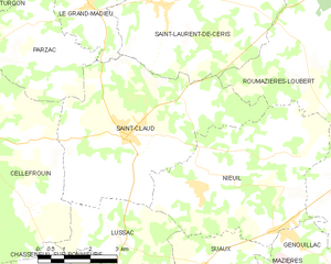
Saint-Claud
- commune in Charente, France
- Country:
- Postal Code: 16450
- Coordinates: 45° 53' 43" N, 0° 27' 54" E
- GPS tracks (wikiloc): [Link]
- Area: 26.75 sq km
- Population: 1074


Parzac
- commune in Charente, France
- Country:
- Postal Code: 16450
- Coordinates: 45° 55' 59" N, 0° 24' 59" E
- GPS tracks (wikiloc): [Link]
- Area: 11.38 sq km
- Population: 137

Turgon
- commune in Charente, France
- Country:
- Postal Code: 16350
- Coordinates: 45° 56' 59" N, 0° 24' 0" E
- GPS tracks (wikiloc): [Link]
- Area: 7.26 sq km
- Population: 86