Le Pin (Le Pin)

- commune in Seine-et-Marne, France
- Country:

- Postal Code: 77181
- Coordinates: 48° 54' 52" N, 2° 37' 45" E


- GPS tracks (wikiloc): [Link]
- Area: 6.7 sq km
- Population: 1411
- Web site: http://www.mairiedelepin.fr
- Wikipedia en: wiki(en)
- Wikipedia: wiki(fr)
- Wikidata storage: Wikidata: Q243392
- Wikipedia Commons Category: [Link]
- Freebase ID: [/m/02r6m4j]
- Freebase ID: [/m/02r6m4j]
- GeoNames ID: Alt: [6456485]
- GeoNames ID: Alt: [6456485]
- SIREN number: [217703636]
- SIREN number: [217703636]
- BnF ID: [15275702g]
- BnF ID: [15275702g]
- INSEE municipality code: 77363
- INSEE municipality code: 77363
Shares border with regions:

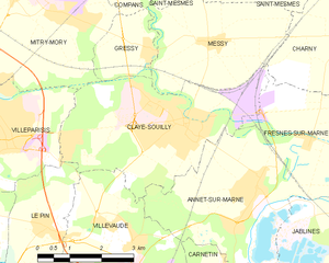
Claye-Souilly
- commune in Seine-et-Marne, France
- Country:
- Postal Code: 77410
- Coordinates: 48° 56' 42" N, 2° 41' 12" E
- GPS tracks (wikiloc): [Link]
- Area: 15.07 sq km
- Population: 12228
- Web site: [Link]

Villevaudé
- commune in Seine-et-Marne, France
- Country:
- Postal Code: 77410
- Coordinates: 48° 54' 50" N, 2° 39' 55" E
- GPS tracks (wikiloc): [Link]
- Area: 9.98 sq km
- Population: 2102
- Web site: [Link]


Brou-sur-Chantereine
- commune in Seine-et-Marne, France
- Country:
- Postal Code: 77177
- Coordinates: 48° 52' 57" N, 2° 37' 46" E
- GPS tracks (wikiloc): [Link]
- Area: 4.28 sq km
- Population: 4411
- Web site: [Link]


Chelles
- commune in Seine-et-Marne, France
- Country:
- Postal Code: 77500
- Coordinates: 48° 52' 43" N, 2° 35' 20" E
- GPS tracks (wikiloc): [Link]
- AboveSeaLevel: 45 м m
- Area: 15.9 sq km
- Population: 53833
- Web site: [Link]


Villeparisis
- commune in Seine-et-Marne, France
- Country:
- Postal Code: 77270
- Coordinates: 48° 56' 34" N, 2° 36' 23" E
- GPS tracks (wikiloc): [Link]
- Area: 8.29 sq km
- Population: 26255
- Web site: [Link]


Courtry
- commune in Seine-et-Marne, France
- Country:
- Postal Code: 77181
- Coordinates: 48° 55' 3" N, 2° 36' 11" E
- GPS tracks (wikiloc): [Link]
- Area: 4.16 sq km
- Population: 6668
- Web site: [Link]