Le Trioulou (Le Trioulou)

- commune in Cantal, France
- Country:

- Postal Code: 15600
- Coordinates: 44° 40' 6" N, 2° 11' 16" E


- GPS tracks (wikiloc): [Link]
- Area: 5.87 sq km
- Population: 108
- Wikipedia en: wiki(en)
- Wikipedia: wiki(fr)
- Wikidata storage: Wikidata: Q809445
- Wikipedia Commons Category: [Link]
- Freebase ID: [/m/03mbbkq]
- GeoNames ID: Alt: [6455606]
- SIREN number: [211502422]
- BnF ID: [152484122]
- INSEE municipality code: 15242
Shares border with regions:

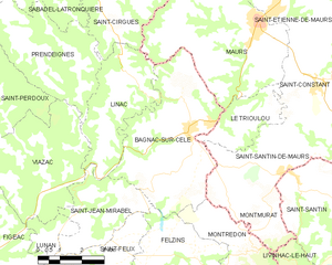
Bagnac-sur-Célé
- commune in Lot, France
- Country:
- Postal Code: 46270
- Coordinates: 44° 39' 59" N, 2° 9' 30" E
- GPS tracks (wikiloc): [Link]
- AboveSeaLevel: 234 м m
- Area: 22.29 sq km
- Population: 1504
- Web site: [Link]
Saint-Constant
- former commune in Cantal, France
- Country:
- Postal Code: 15600
- Coordinates: 44° 41' 5" N, 2° 13' 53" E
- GPS tracks (wikiloc): [Link]
- Area: 21.8 sq km
- Population: 567

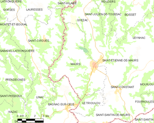
Maurs
- commune in Cantal, France
- Country:
- Postal Code: 15600
- Coordinates: 44° 42' 38" N, 2° 11' 53" E
- GPS tracks (wikiloc): [Link]
- Area: 30.84 sq km
- Population: 2170
- Web site: [Link]


Saint-Santin-de-Maurs
- commune in Cantal, France
- Country:
- Postal Code: 15600
- Coordinates: 44° 39' 3" N, 2° 12' 58" E
- GPS tracks (wikiloc): [Link]
- Area: 14.52 sq km
- Population: 365