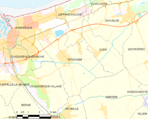
Leffrinckoucke (Leffrinckoucke)
- commune in Nord, France
- Country:

- Postal Code: 59495
- Coordinates: 51° 3' 13" N, 2° 26' 19" E


- GPS tracks (wikiloc): [Link]
- Area: 7.28 sq km
- Population: 4293
- Web site: http://www.ville-leffrinckoucke.net
- Wikipedia en: wiki(en)
- Wikipedia: wiki(fr)
- Wikidata storage: Wikidata: Q665411
- Wikipedia Commons Category: [Link]
- Freebase ID: [/m/03mgycr]
- Freebase ID: [/m/03mgycr]
- GeoNames ID: Alt: [3004244]
- GeoNames ID: Alt: [3004244]
- SIREN number: [215903402]
- SIREN number: [215903402]
- BnF ID: [152669142]
- BnF ID: [152669142]
- VIAF ID: Alt: [245848425]
- VIAF ID: Alt: [245848425]
- WOEID: [605077]
- WOEID: [605077]
- Chemins de mémoire ID: [leffrinckoucke]
- Chemins de mémoire ID: [leffrinckoucke]
- INSEE municipality code: 59340
- INSEE municipality code: 59340
Shares border with regions:


Uxem
- commune in Nord, France
- Country:

- Postal Code: 59229
- Coordinates: 51° 1' 18" N, 2° 29' 0" E


- GPS tracks (wikiloc): [Link]
- Area: 8.27 sq km
- Population: 1410
- Web site: [Link]


Téteghem-Coudekerque-Village
- commune in Nord, France
- Country:

- Postal Code: 59380; 59229
- Coordinates: 51° 1' 10" N, 2° 26' 41" E


- GPS tracks (wikiloc): [Link]
- Area: 30.44 sq km
Ghyvelde
- commune in Nord, France
- Country:

- Postal Code: 59254
- Coordinates: 51° 3' 6" N, 2° 31' 38" E


- GPS tracks (wikiloc): [Link]
- Area: 35.92 sq km
- Web site: [Link]


Dunkirk
- commune in Nord, France
- Country:

- Postal Code: 59279; 59640; 59430; 59240; 59140
- Coordinates: 51° 2' 16" N, 2° 22' 35" E


- GPS tracks (wikiloc): [Link]
- AboveSeaLevel: 4 м m
- Area: 43.89 sq km
- Population: 88876
- Web site: [Link]
