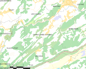
Les Gras (Les Gras)

- commune in Doubs, France
 Hiking in Les Gras
Les Granges is a beautiful area often associated with scenic hiking opportunities, especially in regions such as the French Alps or other mountainous regions named similarly. While specific trails can vary, hiking in mountainous areas like Les Granges typically offers various terrains, from easy walks to challenging hikes, showcasing stunning vistas, alpine flora, and diverse wildlife.
Key Highlights of Hiking in Les Granges:
-
Variety of Trails: You can find trails suitable for all skill levels, from beginners to advanced hikers. Look for local maps or guides that detail the terrain and difficulty levels.
-
Scenic Views: Many trails provide breathtaking views of the surrounding mountains, valleys, and, potentially, glaciers. Sunrise and sunset hikes can be particularly rewarding.
-
Flora and Fauna: Depending on the season, the area is home to vibrant wildflowers and diverse wildlife. Keep your eyes peeled for birds, deer, and other local fauna along your hike.
-
Local Amenities: Check for nearby towns or villages that may offer accommodations, dining options, and additional resources such as guided hikes or equipment rentals.
-
Best Seasons: Late spring to early fall is generally the best time for hiking in mountainous areas, as trails are more accessible and the weather is milder.
-
Safety Considerations: Always check the weather before heading out, wear appropriate footwear, and carry enough water and snacks. Inform someone of your hiking plans for safety reasons.
-
Respect Nature: Follow Leave No Trace principles to preserve the area’s natural beauty and ecosystem.
Before you go, make sure to research specific trails in the Les Granges area to find one that fits your experience level and time constraints. Enjoy your hiking adventure!
- Country:

- Postal Code: 25790
- Coordinates: 46° 59' 41" N, 6° 32' 40" E


- GPS tracks (wikiloc): [Link]
- Area: 14.99 sq km
- Population: 825
- Wikipedia en: wiki(en)
- Wikipedia: wiki(fr)
- Wikidata storage: Wikidata: Q544625
- Wikipedia Commons Category: [Link]
- Freebase ID: [/m/03mh9yf]
- Freebase ID: [/m/03mh9yf]
- GeoNames ID: Alt: [6455719]
- GeoNames ID: Alt: [6455719]
- SIREN number: [212502967]
- SIREN number: [212502967]
- BnF ID: [15252522d]
- BnF ID: [15252522d]
- INSEE municipality code: 25296
- INSEE municipality code: 25296
Shares border with regions:

Grand'Combe-Châteleu
- commune in Doubs, France
Hiking in Grand'Combe-Châteleu
Grand'Combe-Châteleu is a beautiful and less-known destination for hikers in the Jura Mountains of France. The region is characterized by its rolling hills, dense forests, and scenic vistas, making it a great spot for outdoor enthusiasts. Here are some key points to consider when hiking in this area:...
- Country:
- Postal Code: 25570
- Coordinates: 47° 1' 34" N, 6° 34' 12" E
- GPS tracks (wikiloc): [Link]
- Area: 21.46 sq km
- Population: 1477
- Web site: [Link]


Ville-du-Pont
- commune in Doubs, France
Hiking in Ville-du-Pont
Ville-du-Pont is a small commune located in the Jura region of eastern France, known for its picturesque landscapes, lush forests, and winding trails. While it may not be as widely known as some other hiking destinations in France, it offers plenty of opportunities for outdoor enthusiasts....
- Country:
- Postal Code: 25650
- Coordinates: 47° 0' 11" N, 6° 28' 39" E
- GPS tracks (wikiloc): [Link]
- Area: 15.02 sq km
- Population: 307