Les Loges (Les Loges)

- commune in Haute-Marne, France
- Country:

- Postal Code: 52500
- Coordinates: 47° 47' 3" N, 5° 29' 28" E


- GPS tracks (wikiloc): [Link]
- Area: 10.79 sq km
- Population: 136
- Wikipedia en: wiki(en)
- Wikipedia: wiki(fr)
- Wikidata storage: Wikidata: Q1386942
- Wikipedia Commons Category: [Link]
- Freebase ID: [/m/03ntqh4]
- Freebase ID: [/m/03ntqh4]
- GeoNames ID: Alt: [6456201]
- GeoNames ID: Alt: [6456201]
- SIREN number: [215202060]
- SIREN number: [215202060]
- BnF ID: [15263537w]
- BnF ID: [15263537w]
- INSEE municipality code: 52290
- INSEE municipality code: 52290
Shares border with regions:


Champsevraine
- commune in Haute-Marne, France
- Country:
- Postal Code: 52500
- Coordinates: 47° 44' 49" N, 5° 32' 58" E
- GPS tracks (wikiloc): [Link]
- AboveSeaLevel: 280 м m
- Area: 40.77 sq km
- Population: 737
Rivières-le-Bois
- commune in Haute-Marne, France
- Country:
- Postal Code: 52600
- Coordinates: 47° 44' 15" N, 5° 26' 31" E
- GPS tracks (wikiloc): [Link]
- Area: 7.14 sq km
- Population: 74
Violot
- commune in Haute-Marne, France
- Country:
- Postal Code: 52600
- Coordinates: 47° 45' 50" N, 5° 26' 27" E
- GPS tracks (wikiloc): [Link]
- Area: 4.27 sq km
- Population: 73
Torcenay
- commune in Haute-Marne, France
- Country:
- Postal Code: 52600
- Coordinates: 47° 48' 53" N, 5° 27' 53" E
- GPS tracks (wikiloc): [Link]
- Area: 8.49 sq km
- Population: 553
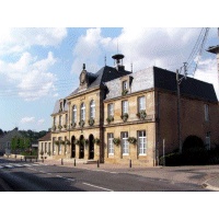

Chalindrey
- commune in Haute-Marne, France
- Country:
- Postal Code: 52600
- Coordinates: 47° 48' 11" N, 5° 25' 40" E
- GPS tracks (wikiloc): [Link]
- Area: 20.05 sq km
- Population: 2437
- Web site: [Link]