Les Pradeaux (Les Pradeaux)

- commune in Puy-de-Dôme, France
- Country:

- Postal Code: 63500
- Coordinates: 45° 30' 45" N, 3° 17' 44" E


- GPS tracks (wikiloc): [Link]
- Area: 5.54 sq km
- Population: 331
- Wikipedia en: wiki(en)
- Wikipedia: wiki(fr)
- Wikidata storage: Wikidata: Q246489
- Wikipedia Commons Category: [Link]
- Freebase ID: [/m/03ql13t]
- GeoNames ID: Alt: [6614911]
- SIREN number: [216302877]
- BnF ID: [15269637m]
- INSEE municipality code: 63287
Shares border with regions:


Parentignat
- commune in Puy-de-Dôme, France
- Country:
- Postal Code: 63500
- Coordinates: 45° 32' 2" N, 3° 17' 27" E
- GPS tracks (wikiloc): [Link]
- Area: 3.71 sq km
- Population: 515
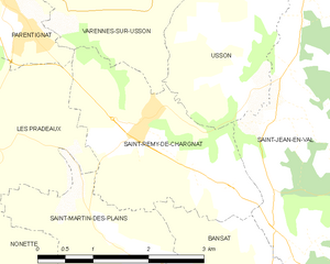
Saint-Rémy-de-Chargnat
- commune in Puy-de-Dôme, France
- Country:
- Postal Code: 63500
- Coordinates: 45° 30' 57" N, 3° 19' 26" E
- GPS tracks (wikiloc): [Link]
- Area: 6.21 sq km
- Population: 560

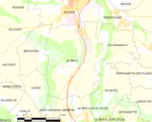
Le Broc
- commune in Puy-de-Dôme, France
- Country:
- Postal Code: 63500
- Coordinates: 45° 30' 3" N, 3° 14' 38" E
- GPS tracks (wikiloc): [Link]
- Area: 17.45 sq km
- Population: 672


Saint-Martin-des-Plains
- commune in Puy-de-Dôme, France
- Country:
- Postal Code: 63570
- Coordinates: 45° 29' 29" N, 3° 19' 12" E
- GPS tracks (wikiloc): [Link]
- Area: 3.87 sq km
- Population: 144