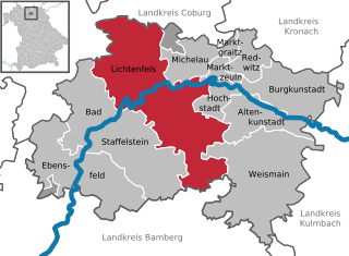
Lichtenfels (Lichtenfels)
- county town of the district of Lichtenfels in the Bavarian administrative region Upper Franconia
Lichtenfels is a beautiful town located in Bavaria, Germany, and offers a variety of hiking opportunities that showcase the region's scenic landscapes, forests, and cultural landmarks. Here’s an overview of what you can expect when hiking in and around Lichtenfels:
Scenic Routes:
-
Fränkische Schweiz (Franconian Switzerland): Lichtenfels is situated near this stunning hiking region known for its limestone cliffs, gorges, and quaint villages. There are numerous hiking trails ranging from easy walks to more challenging routes, with opportunities to explore caverns, castles, and breathtaking viewpoints.
-
The Main River Trail: This scenic route follows the Main River, providing flat and easy hiking. The trail showcases picturesque river landscapes, charming villages, and lovely forested areas.
-
Local Hiking Trails: The area around Lichtenfels has well-marked local trails. The "Hikes Around Lichtenfels" map offers various loops that vary in distance and difficulty, catering to all levels of hikers.
Nature and Wildlife:
Hiking in this region provides a chance to experience diverse flora and fauna. The forests surrounding Lichtenfels are home to various wildlife, including deer, boars, and a variety of bird species. The changing seasons also offer different experiences, from vibrant autumn colors to winter landscapes.
Cultural Landmarks:
While hiking, you can discover local cultural landmarks, including:
- Castles: The region is dotted with historical castles and ruins which often serve as great stopping points along hiking trails.
- Traditional Villages: Quaint villages with traditional Bavarian architecture can be found along many routes, offering a glimpse into local life.
Tips for Hiking in Lichtenfels:
- Trail Maps: Make sure to obtain a map of the local trails or use a hiking app to help navigate the area.
- Weather: Check the weather conditions before heading out, as they can change quickly in the region.
- Gear: Wear appropriate hiking footwear and dress in layers to adapt to changing temperatures.
Access:
Lichtenfels is accessible by train and car, making it an easy starting point for adventurous excursions in Bavaria.
In summary, hiking in and around Lichtenfels offers a blend of natural beauty, cultural experiences, and well-maintained trails, making it a fantastic destination for both novice and experienced hikers.
- Country:

- Postal Code: 96215
- Local Dialing Code: 09571
- Licence Plate Code: LIF
- Coordinates: 50° 8' 0" N, 11° 2' 0" E


- GPS tracks (wikiloc): [Link]
- AboveSeaLevel: 271 м m
- Area: 122.27 sq km
- Population: 20080
- Web site: http://www.lichtenfels-city.de
- Wikipedia en: wiki(en)
- Wikipedia: wiki(de)
- Wikidata storage: Wikidata: Q160405
- Wikipedia Commons Category: [Link]
- Wikipedia Commons Maps Category: [Link]
- Freebase ID: [/m/0dkmp6]
- GeoNames ID: Alt: [6558326]
- VIAF ID: Alt: [240614461]
- OSM relation ID: [1026859]
- GND ID: Alt: [4035612-7]
- archINFORM location ID: [5588]
- MusicBrainz area ID: [5fd6f54f-164a-496a-8def-b9a87f363062]
- Bavarikon ID: [ODB_A00002135]
- NKCR AUT ID: [ge919791]
- German municipality key: 09478139
Shares border with regions:


Altenkunstadt
- municipality of Germany
Altenkunstadt is a quaint town located in Bavaria, Germany, surrounded by picturesque landscapes that make it a great destination for hiking enthusiasts. The region features a variety of trails that cater to different experience levels, from leisurely walks to more challenging hikes....
- Country:

- Postal Code: 96264
- Local Dialing Code: 09572
- Licence Plate Code: LIF
- Coordinates: 50° 7' 0" N, 11° 15' 0" E


- GPS tracks (wikiloc): [Link]
- AboveSeaLevel: 292 м m
- Area: 32.91 sq km
- Population: 5380
- Web site: [Link]


Bad Staffelstein
- municipality of Germany
Bad Staffelstein, located in the Upper Franconia region of Bavaria, Germany, is a wonderful destination for hiking enthusiasts. The area is known for its scenic landscapes, rich history, and a variety of well-marked hiking trails that cater to different skill levels. Here are some highlights and tips for hiking in Bad Staffelstein:...
- Country:

- Postal Code: 96231
- Local Dialing Code: 09573
- Coordinates: 50° 6' 0" N, 10° 58' 0" E


- GPS tracks (wikiloc): [Link]
- AboveSeaLevel: 274 м m
- Area: 99.39 sq km
- Population: 10231
- Web site: [Link]

