Lilienfeld District (Bezirk Lilienfeld)

- district in Austria
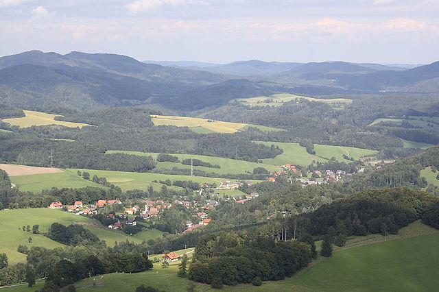
 Hiking in Lilienfeld District
The Lilienfeld District, located in Lower Austria, offers a variety of hiking opportunities that cater to different skill levels and interests. The region is characterized by its beautiful landscapes, picturesque forests, and the famous northern foothills of the Alps. Here are some highlights of hiking in this area:
Scenic Trails
-
Schneeberg: This is one of the most popular hiking destinations in the region. There are several trails leading up to the summit, providing hikers with stunning views of the surroundings. The trail offers varying difficulty levels, suitable for both beginners and experienced hikers.
-
Raxalpe: Part of the Rax mountain range, this area features well-marked hiking paths that lead through dense forests and rocky outcrops. The panoramic views from various vantage points are breathtaking.
Nature and Wildlife
The Lilienfeld District is home to diverse flora and fauna. While hiking, you may encounter various bird species, deer, and other wildlife. The region's natural beauty is particularly striking during the spring and fall when the foliage changes color.
Historical Landmarks
As you hike, you may come across historical sites and cultural landmarks. The Lilienfeld Monastery, for example, is a notable site with a rich history that dates back to the 12th century.
Practical Tips
- Trail Maps: Always carry a detailed map of the area, or consider downloading trail information through hiking apps.
- Weather: Check the local weather forecast before heading out, as conditions can change rapidly in alpine areas.
- Gear: Wear suitable hiking footwear, bring plenty of water, snacks, and layers of clothing to adapt to temperature changes.
Accessibility
Most trails are accessible from nearby towns with parking available at common trailheads. Public transport options also exist, making it easy to reach the more popular hiking areas.
Overall Experience
Hiking in the Lilienfeld District provides opportunities not only for physical activity but also for connecting with nature and exploring the history of Lower Austria. Whether you are looking for a leisurely walk or a challenging hike, the trails in this region are sure to offer a memorable experience.
- Country:

- Licence Plate Code: LF
- Coordinates: 48° 0' 47" N, 15° 36' 32" E


- GPS tracks (wikiloc): [Link]
- AboveSeaLevel: 588 м m
- Area: 931.55 sq km
- Web site: http://www.noel.gv.at/service/bh/lf/bhlf.htm
- Wikipedia en: wiki(en)
- Wikipedia: wiki(de)
- Wikidata storage: Wikidata: Q694463
- Wikipedia Commons Category: [Link]
- Freebase ID: [/m/0flb9_]
- GeoNames ID: Alt: [2772469]
- VIAF ID: Alt: [150270969]
- GND ID: Alt: [4035732-6]
- archINFORM location ID: [14633]
- Library of Congress authority ID: Alt: [n97102122]
Includes regions:

Annaberg, Lower Austria
- municipality in Austria
Hiking in Annaberg, Lower Austria
Annaberg, located in the beautiful region of Lower Austria, offers a range of hiking opportunities that cater to various skill levels and preferences. Nestled in the Northern Limestone Alps, this area is characterized by its stunning landscapes, rich flora and fauna, and picturesque views....
- Country:
- Postal Code: 3222
- Local Dialing Code: 02728
- Licence Plate Code: LF
- Coordinates: 47° 52' 18" N, 15° 22' 34" E
- GPS tracks (wikiloc): [Link]
- AboveSeaLevel: 976 м m
- Area: 63.51 sq km
- Population: 533
- Web site: [Link]


Mitterbach am Erlaufsee
- municipality in Austria
Hiking in Mitterbach am Erlaufsee
Mitterbach am Erlaufsee is a beautiful destination for hiking enthusiasts, located in the Styrian region of Austria. The area is known for its stunning natural scenery, including lush forests, mountainous terrain, and the picturesque Erlaufsee lake itself, making it an ideal setting for outdoor activities....
- Country:
- Postal Code: 3224
- Local Dialing Code: 03882
- Licence Plate Code: LF
- Coordinates: 47° 48' 0" N, 15° 17' 0" E
- GPS tracks (wikiloc): [Link]
- AboveSeaLevel: 789 м m
- Area: 67.32 sq km
- Population: 499
- Web site: [Link]
Kaumberg
- municipality in Austria
Hiking in Kaumberg
Kaumberg, located in the beautiful region of Lower Austria, offers a variety of hiking opportunities for enthusiasts of all levels. The area is rich in scenic landscapes, featuring lush forests, rolling hills, and breathtaking views of the surrounding countryside....
- Country:
- Postal Code: 2572
- Local Dialing Code: 02765
- Licence Plate Code: LF
- Coordinates: 48° 1' 25" N, 15° 53' 42" E
- GPS tracks (wikiloc): [Link]
- AboveSeaLevel: 494 м m
- Area: 43 sq km
- Population: 1016
- Web site: [Link]

Ramsau
- town in Lower Austria, Austria
Hiking in Ramsau
Ramsau, located in Lower Austria, is a picturesque village surrounded by stunning natural landscapes, making it a fantastic destination for hiking enthusiasts. The region offers a variety of trails suited for different skill levels, from easy walks to challenging mountain hikes. Here are some highlights and tips for hiking in Ramsau:...
- Country:
- Postal Code: 3172
- Local Dialing Code: 02764
- Licence Plate Code: LF
- Coordinates: 48° 0' 0" N, 15° 48' 0" E
- GPS tracks (wikiloc): [Link]
- AboveSeaLevel: 470 м m
- Area: 54.69 sq km
- Population: 850
- Web site: [Link]

Hainfeld
- municipality in Austria
Hiking in Hainfeld
Hainfeld, located in Lower Austria, is surrounded by picturesque landscapes, making it a great destination for hiking enthusiasts. The area offers various trails that cater to different skill levels, from easy walks through lush forests to more challenging hikes with steep ascents....
- Country:
- Postal Code: 3170
- Local Dialing Code: 02764
- Licence Plate Code: LF
- Coordinates: 48° 2' 0" N, 15° 46' 0" E
- GPS tracks (wikiloc): [Link]
- AboveSeaLevel: 439 м m
- Area: 44.73 sq km
- Population: 3726
- Web site: [Link]
Kleinzell
- municipality in Austria
Hiking in Kleinzell
Kleinzell is a picturesque area located in Austria, known for its scenic landscapes and outdoor activities, including hiking. The region offers a variety of trails suitable for different skill levels, making it a great destination for both novice and experienced hikers....
- Country:
- Postal Code: 3171
- Local Dialing Code: 02766
- Licence Plate Code: LF
- Coordinates: 47° 59' 0" N, 15° 45' 0" E
- GPS tracks (wikiloc): [Link]
- AboveSeaLevel: 480 м m
- Area: 93.02 sq km
- Population: 831
- Web site: [Link]

Hohenberg, Lower Austria
- municipality in Austria
Hiking in Hohenberg, Lower Austria
Hohenberg, located in Lower Austria, is a great destination for hiking enthusiasts who appreciate scenic landscapes and a blend of nature and culture. The region is characterized by beautiful rolling hills, lush forests, and picturesque vineyards, making it an excellent spot for both leisurely walks and more challenging hikes....
- Country:
- Postal Code: 3192
- Local Dialing Code: 02767
- Licence Plate Code: LF
- Coordinates: 47° 54' 0" N, 15° 37' 0" E
- GPS tracks (wikiloc): [Link]
- AboveSeaLevel: 488 м m
- Area: 56.62 sq km
- Population: 1515
- Web site: [Link]
Sankt Veit an der Gölsen
- municipality in Austria
Hiking in Sankt Veit an der Gölsen
Sankt Veit an der Gölsen, located in Lower Austria, offers a variety of hiking opportunities set against beautiful landscapes, including rolling hills, forests, and picturesque views. Here are some key points for hiking in this area:...
- Country:
- Postal Code: 3161
- Local Dialing Code: 02763
- Licence Plate Code: LF
- Coordinates: 48° 2' 0" N, 15° 40' 0" E
- GPS tracks (wikiloc): [Link]
- AboveSeaLevel: 369 м m
- Area: 78.14 sq km
- Population: 3915
- Web site: [Link]

Türnitz
- municipality in Austria
Hiking in Türnitz
Türnitz, located in the scenic Lower Austria region, is a fantastic destination for hiking enthusiasts. The area is characterized by its stunning natural landscapes, including lush forests, rolling hills, and picturesque mountains. Here are some highlights and tips for hiking in Türnitz:...
- Country:
- Postal Code: 3184
- Local Dialing Code: 02769
- Licence Plate Code: LF
- Coordinates: 47° 55' 55" N, 15° 29' 27" E
- GPS tracks (wikiloc): [Link]
- AboveSeaLevel: 466 м m
- Area: 145.53 sq km
- Population: 1912
- Web site: [Link]
Eschenau
- municipality in Austria
Hiking in Eschenau
Eschenau, located in the scenic region of Bavaria, Germany, offers several hiking opportunities that highlight the area's natural beauty and cultural heritage....
- Country:
- Postal Code: 3153
- Local Dialing Code: 02762
- Licence Plate Code: LF
- Coordinates: 48° 2' 0" N, 15° 34' 0" E
- GPS tracks (wikiloc): [Link]
- AboveSeaLevel: 406 м m
- Area: 24.71 sq km
- Population: 1306
- Web site: [Link]

Sankt Aegyd am Neuwalde
- municipality in Austria
Hiking in Sankt Aegyd am Neuwalde
Sankt Aegyd am Neuwalde, located in the picturesque region of Lower Austria, is a fantastic destination for hiking enthusiasts. Surrounded by the stunning landscapes of the Vienna Woods and the foothills of the Alps, it offers a variety of trails suitable for all skill levels....
- Country:
- Postal Code: 3193
- Local Dialing Code: 02768
- Licence Plate Code: LF
- Coordinates: 47° 51' 0" N, 15° 33' 0" E
- GPS tracks (wikiloc): [Link]
- AboveSeaLevel: 588 м m
- Area: 184.6 sq km
- Population: 1901
- Web site: [Link]
Traisen
- municipality in Austria
Hiking in Traisen
Traisen, a picturesque village in Austria, is surrounded by the lush landscapes of the Lower Austria region, making it a great spot for hiking enthusiasts. Here are some aspects to consider when planning a hiking trip in and around Traisen:...
- Country:
- Postal Code: 3160
- Local Dialing Code: 02762
- Licence Plate Code: LF
- Coordinates: 48° 2' 38" N, 15° 36' 32" E
- GPS tracks (wikiloc): [Link]
- AboveSeaLevel: 356 м m
- Area: 6.79 sq km
- Population: 3453
- Web site: [Link]
Rohrbach an der Gölsen
- municipality in Austria
Hiking in Rohrbach an der Gölsen
Rohrbach an der Gölsen, a charming village located in Lower Austria, offers beautiful hiking opportunities with scenic views and diverse landscapes. The area is characterized by its rolling hills, lush forests, and the Gölsen river, making it an ideal spot for outdoor enthusiasts....
- Country:
- Postal Code: 3163
- Local Dialing Code: 02764
- Licence Plate Code: LF
- Coordinates: 48° 2' 53" N, 15° 44' 30" E
- GPS tracks (wikiloc): [Link]
- AboveSeaLevel: 402 м m
- Area: 14.77 sq km
- Population: 1556
- Web site: [Link]

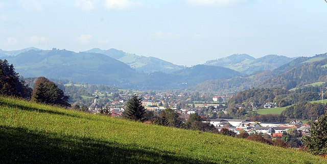
Lilienfeld
- municipality in Austria
Hiking in Lilienfeld
Lilienfeld is located in Austria, surrounded by stunning natural landscapes and offering various hiking opportunities. The region is characterized by its beautiful forests, rolling hills, alpine meadows, and scenic views of the surrounding mountains....
- Country:
- Postal Code: 3180
- Local Dialing Code: 02762
- Licence Plate Code: LF
- Coordinates: 48° 1' 0" N, 15° 36' 0" E
- GPS tracks (wikiloc): [Link]
- AboveSeaLevel: 383 м m
- Area: 53.95 sq km
- Population: 2833
- Web site: [Link]