Lizy-sur-Ourcq (Lizy-sur-Ourcq)

- commune in Seine-et-Marne, France
- Country:

- Postal Code: 77440
- Coordinates: 49° 1' 31" N, 3° 1' 19" E


- GPS tracks (wikiloc): [Link]
- Area: 11.16 sq km
- Population: 3628
- Web site: http://www.lizy-sur-ourcq.com/
- Wikipedia en: wiki(en)
- Wikipedia: wiki(fr)
- Wikidata storage: Wikidata: Q262081
- Wikipedia Commons Category: [Link]
- Freebase ID: [/m/02qwh65]
- Freebase ID: [/m/02qwh65]
- GeoNames ID: Alt: [2998027]
- GeoNames ID: Alt: [2998027]
- SIREN number: [217702570]
- SIREN number: [217702570]
- BnF ID: [15275597f]
- BnF ID: [15275597f]
- VIAF ID: Alt: [148852029]
- VIAF ID: Alt: [148852029]
- archINFORM location ID: [5796]
- archINFORM location ID: [5796]
- Library of Congress authority ID: Alt: [nr92035623]
- Library of Congress authority ID: Alt: [nr92035623]
- NKCR AUT ID: [ge961839]
- NKCR AUT ID: [ge961839]
- INSEE municipality code: 77257
- INSEE municipality code: 77257
Shares border with regions:


Le Plessis-Placy
- commune in Seine-et-Marne, France
- Country:
- Postal Code: 77440
- Coordinates: 49° 3' 30" N, 2° 59' 23" E
- GPS tracks (wikiloc): [Link]
- Area: 8.2 sq km
- Population: 273


Mary-sur-Marne
- commune in Seine-et-Marne, France
- Country:
- Postal Code: 77440
- Coordinates: 49° 0' 54" N, 3° 1' 44" E
- GPS tracks (wikiloc): [Link]
- Area: 2.22 sq km
- Population: 1186
- Web site: [Link]


Ocquerre
- commune in Seine-et-Marne, France
- Country:
- Postal Code: 77440
- Coordinates: 49° 2' 19" N, 3° 3' 27" E
- GPS tracks (wikiloc): [Link]
- Area: 10.12 sq km
- Population: 450
- Web site: [Link]

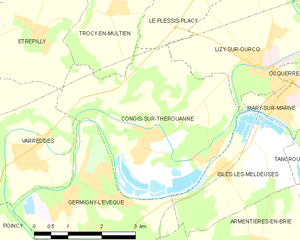
Congis-sur-Thérouanne
- commune in Seine-et-Marne, France
- Country:
- Postal Code: 77440
- Coordinates: 49° 0' 25" N, 2° 58' 31" E
- GPS tracks (wikiloc): [Link]
- Area: 15.12 sq km
- Population: 1777
- Web site: [Link]

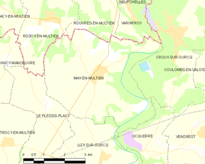
May-en-Multien
- commune in Seine-et-Marne, France
- Country:
- Postal Code: 77145
- Coordinates: 49° 4' 18" N, 3° 1' 17" E
- GPS tracks (wikiloc): [Link]
- Area: 19.15 sq km
- Population: 905