Locoal-Mendon (Locoal-Mendon)

- commune in Morbihan, France
- Country:

- Postal Code: 56550
- Coordinates: 47° 42' 42" N, 3° 6' 18" E


- GPS tracks (wikiloc): [Link]
- Area: 39.97 sq km
- Population: 3365
- Web site: http://www.locoal-mendon.fr
- Wikipedia en: wiki(en)
- Wikipedia: wiki(fr)
- Wikidata storage: Wikidata: Q71115
- Wikipedia Commons Category: [Link]
- Freebase ID: [/m/03c1070]
- GeoNames ID: Alt: [6437297]
- SIREN number: [215601196]
- BnF ID: [152653683]
- INSEE municipality code: 56119
Shares border with regions:

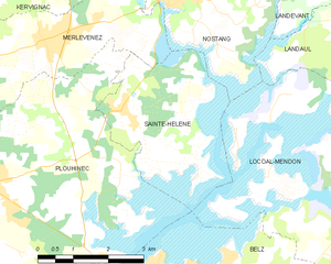
Sainte-Hélène
- commune in Morbihan, France
- Country:
- Postal Code: 56700
- Coordinates: 47° 43' 12" N, 3° 12' 17" E
- GPS tracks (wikiloc): [Link]
- Area: 8.08 sq km
- Population: 1208


Plouhinec
- commune in Morbihan, France
- Country:
- Postal Code: 56680
- Coordinates: 47° 41' 51" N, 3° 15' 4" E
- GPS tracks (wikiloc): [Link]
- AboveSeaLevel: 20 м m
- Area: 35.58 sq km
- Population: 5307
- Web site: [Link]

Ploemel
- commune in Morbihan, France
- Country:
- Postal Code: 56400
- Coordinates: 47° 39' 2" N, 3° 4' 20" E
- GPS tracks (wikiloc): [Link]
- Area: 25.16 sq km
- Population: 2787
- Web site: [Link]

Brech
- commune in Morbihan, France
- Country:
- Postal Code: 56400
- Coordinates: 47° 43' 17" N, 2° 59' 55" E
- GPS tracks (wikiloc): [Link]
- Area: 40.86 sq km
- Population: 6661
- Web site: [Link]

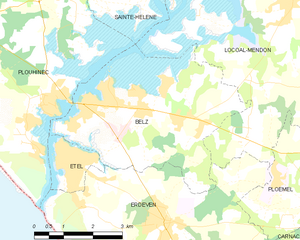
Belz
- commune in Morbihan, France
- Country:
- Postal Code: 56550
- Coordinates: 47° 40' 33" N, 3° 10' 12" E
- GPS tracks (wikiloc): [Link]
- Area: 15.67 sq km
- Population: 3731
- Web site: [Link]


Erdeven
- commune in Morbihan, France
- Country:
- Postal Code: 56410
- Coordinates: 47° 38' 32" N, 3° 9' 24" E
- GPS tracks (wikiloc): [Link]
- Area: 30.64 sq km
- Population: 3583
- Web site: [Link]


Nostang
- commune in Morbihan, France
- Country:
- Postal Code: 56690
- Coordinates: 47° 44' 59" N, 3° 11' 16" E
- GPS tracks (wikiloc): [Link]
- Area: 15.71 sq km
- Population: 1512
- Web site: [Link]

Landaul
- commune in Morbihan, France
- Country:
- Postal Code: 56690
- Coordinates: 47° 44' 54" N, 3° 4' 34" E
- GPS tracks (wikiloc): [Link]
- Area: 17.35 sq km
- Population: 2262