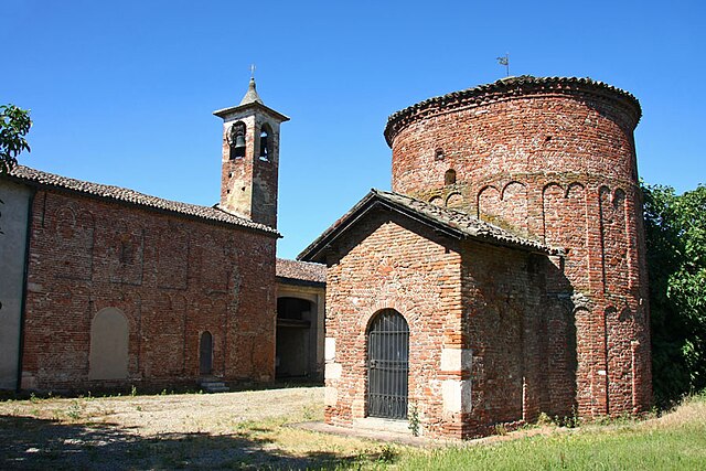
Lomello (Lomello)
.svg)
- Italian comune
 Hiking in Lomello
Lomello, located in the Lombardy region of northern Italy, is not widely known as a hiking destination compared to more mountainous areas in Italy. However, the surrounding countryside and the Po River region offer some opportunities for scenic walks and leisurely hikes.
Hiking Opportunities in and around Lomello:
-
Countryside Paths: The area around Lomello features flat, rural landscapes with farms, rivers, and fields. You can find various paths that can be explored for a peaceful walk and to enjoy the local scenery.
-
Navigli di Pavia: Just a short distance from Lomello, the Navigli canals offer paths for walking and cycling. The area is rich in history and provides a picturesque setting for outdoor activities.
-
Po River Park: Located a bit further away, the Po River Park (Parco del Ticino) is a beautiful natural area that allows for hiking, birdwatching, and enjoying the riverside flora. It is a great place to explore the natural habitats of the region.
-
Suggested Routes: While there are no official marked hiking trails in Lomello, you can create your own routes by following local roads and farm paths while being mindful of traffic. It’s a good idea to carry a map or use a GPS device to navigate.
-
Seasonal Considerations: The best time for hiking in the Lomello area is during the spring and autumn months when the weather is mild, and you can appreciate the blooming fields or the changing foliage.
Preparing for Your Hike:
- Footwear: Comfortable walking shoes or hiking boots are essential, especially on uneven or rural paths.
- Clothing: Dress in layers; it can be chilly in the mornings and warmer by midday.
- Hydration and Snacks: Carry water and some snacks, especially if you plan on spending several hours out.
- Local Map: Consider getting a local map or downloading offline maps before heading out, as some areas may have limited reception.
Conclusion:
While Lomello may not be the primary hiking destination in Italy, the surrounding landscapes offer opportunities for peaceful walks and an appreciation of the local countryside. If you're looking for more adventurous hiking, consider traveling to the nearby hills or mountains in the Lombardy region. Always check local conditions and maps before heading out. Enjoy your hiking!
- Country:

- Postal Code: 27034
- Local Dialing Code: 0384
- Licence Plate Code: PV
- Coordinates: 45° 7' 19" N, 8° 47' 50" E


- GPS tracks (wikiloc): [Link]
- AboveSeaLevel: 99 м m
- Area: 22.36 sq km
- Population: 2177
- Web site: http://www.comune.lomello.pv.it
- Wikipedia en: wiki(en)
- Wikipedia: wiki(it)
- Wikidata storage: Wikidata: Q40039
- Wikipedia Commons Category: [Link]
- Freebase ID: [/m/0gjjlx]
- GeoNames ID: Alt: [6540358]
- VIAF ID: Alt: [242579233]
- OSM relation ID: [44207]
- GND ID: Alt: [4111370-6]
- TGN ID: [7006029]
- UN/LOCODE: [ITEXO]
- Digital Atlas of the Roman Empire ID: [5442]
- ISTAT ID: 018083
- Italian cadastre code: E662
Shares border with regions:

Velezzo Lomellina
- Italian comune
Hiking in Velezzo Lomellina
Velezzo Lomellina is a small town located in the Lombardy region of Northern Italy, known for its agricultural landscape and scenic beauty. While it may not be a prominent hiking destination compared to more mountainous areas in Italy, there are still opportunities for outdoor activities and nature walks in the surrounding countryside....
- Country:
- Postal Code: 27020
- Local Dialing Code: 0384
- Licence Plate Code: PV
- Coordinates: 45° 9' 44" N, 8° 44' 8" E
- GPS tracks (wikiloc): [Link]
- AboveSeaLevel: 98 м m
- Area: 8.17 sq km
- Population: 102
- Web site: [Link]


Villa Biscossi
- Italian comune
Hiking in Villa Biscossi
Villa Biscossi is a picturesque location that is often appreciated for its natural beauty and outdoor activities, including hiking. Although it may not be as widely known as some larger hiking destinations, it offers a variety of trails and landscapes that can appeal to hikers of all levels....
- Country:
- Postal Code: 27035
- Local Dialing Code: 0384
- Licence Plate Code: PV
- Coordinates: 45° 5' 0" N, 8° 47' 0" E
- GPS tracks (wikiloc): [Link]
- AboveSeaLevel: 90 м m
- Area: 4.88 sq km
- Population: 76
- Web site: [Link]


San Giorgio di Lomellina
- Italian comune
Hiking in San Giorgio di Lomellina
San Giorgio di Lomellina is a charming town located in the Lombardy region of Italy. While it may not be as well-known for hiking as some of Italy's more famous mountainous areas, it still offers opportunities for outdoor enthusiasts to explore the surrounding nature....
- Country:
- Postal Code: 27020
- Local Dialing Code: 0384
- Licence Plate Code: PV
- Coordinates: 45° 12' 0" N, 8° 46' 0" E
- GPS tracks (wikiloc): [Link]
- AboveSeaLevel: 99 м m
- Area: 25.45 sq km
- Population: 1059
- Web site: [Link]


Ottobiano
- Italian comune
Hiking in Ottobiano
Ottobiano, a small comune located in the Lombardy region of Italy, is known primarily for its motorsport activities due to the famous motocross track, but it also offers opportunities for those who enjoy hiking and exploring nature....
- Country:
- Postal Code: 27030
- Local Dialing Code: 0384
- Licence Plate Code: PV
- Coordinates: 45° 9' 0" N, 8° 50' 0" E
- GPS tracks (wikiloc): [Link]
- AboveSeaLevel: 96 м m
- Area: 24.98 sq km
- Population: 1114
- Web site: [Link]
Ferrera Erbognone
- Italian comune
Hiking in Ferrera Erbognone
Ferrera Erbognone is a small town in the Lombardy region of Italy. It's located near the Po River and is surrounded by beautiful natural landscapes, making it a great spot for hiking enthusiasts. While specific trails in Ferrera Erbognone may not be as well-known as those in larger national parks, there are still many opportunities for outdoor exploration and enjoyment in the surrounding areas....
- Country:
- Postal Code: 27032
- Local Dialing Code: 0382
- Licence Plate Code: PV
- Coordinates: 45° 7' 0" N, 8° 52' 0" E
- GPS tracks (wikiloc): [Link]
- AboveSeaLevel: 89 м m
- Area: 19 sq km
- Population: 1196
- Web site: [Link]


Mede
- Italian comune
Hiking in Mede
Mede is a charming town located in the Lombardy region of Italy, not far from the bustling city of Milan. While it's not as famous for hiking as some other areas in Lombardy, there are still opportunities for outdoor enthusiasts to explore the surrounding countryside and connected natural areas....
- Country:
- Postal Code: 27035
- Local Dialing Code: 0384
- Licence Plate Code: PV
- Coordinates: 45° 6' 0" N, 8° 44' 0" E
- GPS tracks (wikiloc): [Link]
- AboveSeaLevel: 93 м m
- Area: 32.89 sq km
- Population: 6576
- Web site: [Link]
Semiana
- Italian comune
Hiking in Semiana
Semiana, located in the Lombardy region of northern Italy, is an excellent destination for hiking enthusiasts, offering a mix of beautiful landscapes, charming villages, and rich cultural heritage. Here’s an overview of what you can expect when hiking in Semiana:...
- Country:
- Postal Code: 27020
- Local Dialing Code: 0384
- Licence Plate Code: PV
- Coordinates: 45° 8' 0" N, 8° 44' 0" E
- GPS tracks (wikiloc): [Link]
- AboveSeaLevel: 97 м m
- Area: 9.72 sq km
- Population: 223
- Web site: [Link]


Galliavola
- Italian comune
Hiking in Galliavola
Galliavola is a small village located in Italy, specifically in the region of Lombardy. While it may not be as well-known as some larger hiking destinations, it is surrounded by beautiful landscapes and can be a great starting point for exploring the nearby countryside....
- Country:
- Postal Code: 27034
- Local Dialing Code: 0384
- Licence Plate Code: PV
- Coordinates: 45° 6' 0" N, 8° 49' 0" E
- GPS tracks (wikiloc): [Link]
- AboveSeaLevel: 90 м m
- Area: 8 sq km
- Population: 194
- Web site: [Link]