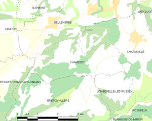
Longevelle-lès-Russey (Longevelle-lès-Russey)

- commune in Doubs, France
 Hiking in Longevelle-lès-Russey
Longevelle-lès-Russey is a charming commune located in the Doubs department in the Bourgogne-Franche-Comté region of France. The area is characterized by its beautiful landscapes, lush forests, and rolling hills, making it an attractive destination for hiking enthusiasts.
Hiking Highlights:
-
Scenic Trails: The region offers various hiking trails ranging from easy walks to more challenging routes. The trails will take you through dense woodlands, past charming farms, and alongside rivers, providing opportunities to enjoy nature and local wildlife.
-
Vuyy Nature Reserve: Nearby, the Vuyy Nature Reserve provides an excellent place for hikers to explore diverse ecosystems. The area is rich with flora and fauna and perfect for nature lovers.
-
Cultural Landmarks: Hiking in Longevelle-lès-Russey or the surrounding areas may also lead you to historical landmarks and charming villages, allowing for a mix of nature and culture during your trek.
Practical Information:
-
Trail Maps: It’s advisable to have a detailed map or a reliable GPS device to help navigate the trails, as signage may vary.
-
Best Time to Visit: The best time for hiking is during the spring and fall when temperatures are moderate and the scenery is particularly beautiful.
-
Equipment: Good hiking shoes are essential, and depending on the season, consider layering your clothing. Always carry water, snacks, and potentially a first-aid kit.
-
Local Regulations: Be sure to check for any rules regarding the trails and nature reserves, including any open or closed routes, especially during hunting seasons or environmental conservation efforts.
Conclusion:
Whether you are looking for a peaceful escape into nature or an adventurous challenge, hiking around Longevelle-lès-Russey offers a delightful experience immersed in French countryside charm. Enjoy your hike!
- Country:

- Postal Code: 25380
- Coordinates: 47° 13' 32" N, 6° 39' 5" E


- GPS tracks (wikiloc): [Link]
- AboveSeaLevel: 714 м m
- Area: 2.56 sq km
- Population: 42
- Wikipedia en: wiki(en)
- Wikipedia: wiki(fr)
- Wikidata storage: Wikidata: Q907383
- Wikipedia Commons Category: [Link]
- Freebase ID: [/m/03mgxrg]
- Freebase ID: [/m/03mgxrg]
- GeoNames ID: Alt: [6616223]
- GeoNames ID: Alt: [6616223]
- SIREN number: [212503445]
- SIREN number: [212503445]
- INSEE municipality code: 25344
- INSEE municipality code: 25344
Shares border with regions:

Chamesey
- commune in Doubs, France
Hiking in Chamesey
Chamonix, often referred to as Chamesey, is a world-renowned destination for outdoor enthusiasts and hikers. Nestled in the French Alps, near the Mont Blanc massif, Chamonix offers a variety of hiking trails suitable for all levels of experience. Here are some key points to keep in mind when hiking in the Chamonix region:...
- Country:
- Postal Code: 25380
- Coordinates: 47° 14' 13" N, 6° 38' 57" E
- GPS tracks (wikiloc): [Link]
- Area: 6.42 sq km
- Population: 129