Lorcières (Lorcières)

- commune in Cantal, France
- Country:

- Postal Code: 15320
- Coordinates: 44° 57' 28" N, 3° 16' 27" E


- GPS tracks (wikiloc): [Link]
- Area: 21.82 sq km
- Population: 175
- Wikipedia en: wiki(en)
- Wikipedia: wiki(fr)
- Wikidata storage: Wikidata: Q805928
- Wikipedia Commons Category: [Link]
- Freebase ID: [/m/03mb7vd]
- GeoNames ID: Alt: [6614974]
- SIREN number: [211501077]
- BnF ID: [152482773]
- INSEE municipality code: 15107
Shares border with regions:

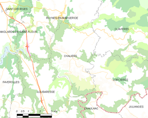
Chaliers
- commune in Cantal, France
- Country:
- Postal Code: 15320
- Coordinates: 44° 57' 24" N, 3° 13' 40" E
- GPS tracks (wikiloc): [Link]
- Area: 18.37 sq km
- Population: 169
Julianges
- commune in Lozère, France
- Country:
- Postal Code: 48140
- Coordinates: 44° 55' 48" N, 3° 18' 32" E
- GPS tracks (wikiloc): [Link]
- Area: 9.42 sq km
- Population: 58

Chaulhac
- commune in Lozère, France
- Country:
- Postal Code: 48140
- Coordinates: 44° 55' 20" N, 3° 15' 24" E
- GPS tracks (wikiloc): [Link]
- Area: 9.47 sq km
- Population: 74


Clavières
- commune in Cantal, France
- Country:
- Postal Code: 15320
- Coordinates: 44° 59' 9" N, 3° 16' 36" E
- GPS tracks (wikiloc): [Link]
- Area: 44.66 sq km
- Population: 212