Lorcy (Lorcy)

- commune in Loiret, France
- Country:

- Postal Code: 45490
- Coordinates: 48° 3' 20" N, 2° 32' 2" E


- GPS tracks (wikiloc): [Link]
- Area: 16.75 sq km
- Population: 559
- Wikipedia en: wiki(en)
- Wikipedia: wiki(fr)
- Wikidata storage: Wikidata: Q1423775
- Wikipedia Commons Category: [Link]
- Freebase ID: [/m/03nwjlb]
- GeoNames ID: Alt: [6434635]
- SIREN number: [214501868]
- BnF ID: [15260578r]
- INSEE municipality code: 45186
Shares border with regions:


Corbeilles
- commune in Loiret, France
- Country:
- Postal Code: 45490
- Coordinates: 48° 4' 20" N, 2° 32' 57" E
- GPS tracks (wikiloc): [Link]
- Area: 32.62 sq km
- Population: 1544
- Web site: [Link]

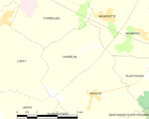
Chapelon
- commune in Loiret, France
- Country:
- Postal Code: 45270
- Coordinates: 48° 2' 13" N, 2° 34' 42" E
- GPS tracks (wikiloc): [Link]
- Area: 6.52 sq km
- Population: 268


Juranville
- commune in Loiret, France
- Country:
- Postal Code: 45340
- Coordinates: 48° 3' 39" N, 2° 29' 2" E
- GPS tracks (wikiloc): [Link]
- Area: 15.23 sq km
- Population: 455


Ladon
- commune in Loiret, France
- Country:
- Postal Code: 45270
- Coordinates: 48° 0' 10" N, 2° 32' 20" E
- GPS tracks (wikiloc): [Link]
- Area: 13.75 sq km
- Population: 1406


Mézières-en-Gâtinais
- commune in Loiret, France
- Country:
- Postal Code: 45270
- Coordinates: 48° 2' 6" N, 2° 29' 24" E
- GPS tracks (wikiloc): [Link]
- Area: 9.86 sq km
- Population: 270