Lothey (Lothey)

- commune in Finistère, France
- Country:

- Postal Code: 29190
- Coordinates: 48° 10' 56" N, 4° 1' 40" E


- GPS tracks (wikiloc): [Link]
- AboveSeaLevel: 80 м m
- Area: 13.48 sq km
- Population: 467
- Wikipedia en: wiki(en)
- Wikipedia: wiki(fr)
- Wikidata storage: Wikidata: Q474677
- Wikipedia Commons Gallery: [Link]
- Wikipedia Commons Category: [Link]
- Freebase ID: [/m/03gxxzl]
- GeoNames ID: Alt: [2997522]
- SIREN number: [212901425]
- BnF ID: [15254491f]
- INSEE municipality code: 29142
Shares border with regions:
Herby [CC BY-SA 4.0 (https://creativecommons.org/licenses/by-sa/4.0)], via Wikimedia Commons" rel="noindex" href="Ch%C3%A2teaulin">
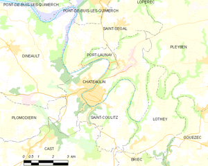
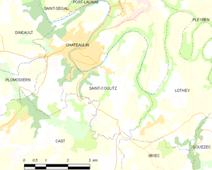
Châteaulin
- commune in Finistère, France
- Country:
- Postal Code: 29150
- Coordinates: 48° 12' 0" N, 4° 5' 0" E
- GPS tracks (wikiloc): [Link]
- Area: 20.81 sq km
- Population: 5227
- Web site: [Link]

Briec
- commune in Finistère, France
- Country:
- Postal Code: 29510
- Coordinates: 48° 6' 6" N, 3° 59' 54" E
- GPS tracks (wikiloc): [Link]
- Area: 67.87 sq km
- Population: 5625
- Web site: [Link]


Cast
- commune in Finistère, France
- Country:
- Postal Code: 29150
- Coordinates: 48° 9' 26" N, 4° 8' 20" E
- GPS tracks (wikiloc): [Link]
- Area: 37.66 sq km
- Population: 1620
- Web site: [Link]


Gouézec
- commune in Finistère, France
- Country:
- Postal Code: 29190
- Coordinates: 48° 10' 11" N, 3° 58' 22" E
- GPS tracks (wikiloc): [Link]
- Area: 30.94 sq km
- Population: 1106
- Web site: [Link]

Pleyben
- commune in Finistère, France
- Country:
- Postal Code: 29190
- Coordinates: 48° 14' 0" N, 3° 58' 0" E
- GPS tracks (wikiloc): [Link]
- Area: 76.04 sq km
- Population: 3743
- Web site: [Link]

Saint-Coulitz
- commune in Finistère, France
- Country:
- Postal Code: 29150
- Coordinates: 48° 11' 27" N, 4° 3' 35" E
- GPS tracks (wikiloc): [Link]
- Area: 11.22 sq km
- Population: 425
- Web site: [Link]