Loué (Loué)
- commune in Sarthe, France
- Country:

- Postal Code: 72540
- Coordinates: 47° 59' 44" N, 0° 9' 12" E


- GPS tracks (wikiloc): [Link]
- Area: 15.85 sq km
- Population: 2231
- Web site: http://www.ville-loue.fr
- Wikipedia en: wiki(en)
- Wikipedia: wiki(fr)
- Wikidata storage: Wikidata: Q540970
- Wikipedia Commons Category: [Link]
- Freebase ID: [/m/03qj1f8]
- GeoNames ID: Alt: [6442600]
- SIREN number: [217201680]
- BnF ID: [15273723z]
- INSEE municipality code: 72168
Shares border with regions:


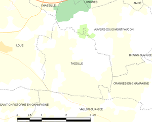
Tassillé
- commune in Sarthe, France
- Country:

- Postal Code: 72540
- Coordinates: 47° 59' 34" N, 0° 5' 36" E


- GPS tracks (wikiloc): [Link]
- Area: 6.46 sq km
- Population: 143
- Web site: [Link]


Joué-en-Charnie
- commune in Sarthe, France
- Country:

- Postal Code: 72540
- Coordinates: 48° 1' 4" N, 0° 11' 27" E


- GPS tracks (wikiloc): [Link]
- Area: 23.53 sq km
- Population: 646


Saint-Christophe-en-Champagne
- commune in Sarthe, France
- Country:

- Postal Code: 72540
- Coordinates: 47° 58' 2" N, 0° 8' 16" E


- GPS tracks (wikiloc): [Link]
- Area: 7.81 sq km
- Population: 201


Vallon-sur-Gée
- commune in Sarthe, France
- Country:

- Postal Code: 72540
- Coordinates: 47° 57' 46" N, 0° 4' 6" E


- GPS tracks (wikiloc): [Link]
- Area: 17.15 sq km
- Population: 799
- Web site: [Link]


Auvers-sous-Montfaucon
- commune in Sarthe, France
- Country:

- Postal Code: 72540
- Coordinates: 48° 0' 22" N, 0° 4' 14" E


- GPS tracks (wikiloc): [Link]
- Area: 7.49 sq km
- Population: 247
- Web site: [Link]


Chassillé
- commune in Sarthe, France
- Country:

- Postal Code: 72540
- Coordinates: 48° 1' 14" N, 0° 6' 58" E


- GPS tracks (wikiloc): [Link]
- Area: 7.27 sq km
- Population: 246


Mareil-en-Champagne
- commune in Sarthe, France
- Country:

- Postal Code: 72540
- Coordinates: 47° 59' 5" N, 0° 10' 8" E


- GPS tracks (wikiloc): [Link]
- Area: 7.97 sq km
- Population: 365
