Lozanne (Lozanne)

- commune in Rhône, France
- Country:

- Postal Code: 69380
- Coordinates: 45° 51' 26" N, 4° 40' 51" E


- GPS tracks (wikiloc): [Link]
- Area: 5.5 sq km
- Population: 2630
- Web site: http://mairielozanne.fr
- Wikipedia en: wiki(en)
- Wikipedia: wiki(fr)
- Wikidata storage: Wikidata: Q1961
- Wikipedia Commons Category: [Link]
- Freebase ID: [/m/03ql6w2]
- GeoNames ID: Alt: [6441704]
- SIREN number: [216901215]
- BnF ID: [15272209s]
- archINFORM location ID: [4299]
- INSEE municipality code: 69121
Shares border with regions:


Belmont-d'Azergues
- commune in Rhône, France
- Country:
- Postal Code: 69380
- Coordinates: 45° 52' 5" N, 4° 40' 10" E
- GPS tracks (wikiloc): [Link]
- AboveSeaLevel: 300 м m
- Area: 1.51 sq km
- Population: 631


Civrieux-d'Azergues
- commune in Rhône, France
- Country:
- Postal Code: 69380
- Coordinates: 45° 51' 29" N, 4° 42' 47" E
- GPS tracks (wikiloc): [Link]
- Area: 5.02 sq km
- Population: 1524
- Web site: [Link]


Dommartin
- commune in Rhône, France
- Country:
- Postal Code: 69380
- Coordinates: 45° 50' 6" N, 4° 42' 41" E
- GPS tracks (wikiloc): [Link]
- Area: 7.22 sq km
- Population: 2584
- Web site: [Link]

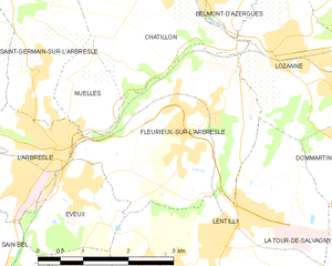
Fleurieux-sur-l'Arbresle
- commune in Rhône, France
- Country:
- Postal Code: 69210
- Coordinates: 45° 50' 11" N, 4° 39' 9" E
- GPS tracks (wikiloc): [Link]
- Area: 9.51 sq km
- Population: 2334
- Web site: [Link]

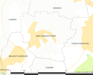
Saint-Jean-des-Vignes
- commune in Rhône, France
- Country:
- Postal Code: 69380
- Coordinates: 45° 52' 33" N, 4° 41' 4" E
- GPS tracks (wikiloc): [Link]
- Area: 2.57 sq km
- Population: 416

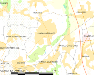
Chazay-d'Azergues
- commune in Rhône, France
- Country:
- Postal Code: 69380
- Coordinates: 45° 52' 33" N, 4° 42' 47" E
- GPS tracks (wikiloc): [Link]
- Area: 5.94 sq km
- Population: 4095
- Web site: [Link]


Châtillon
- commune in Rhône, France
- Country:
- Postal Code: 69380
- Coordinates: 45° 52' 38" N, 4° 38' 45" E
- GPS tracks (wikiloc): [Link]
- Area: 10.71 sq km
- Population: 2178
- Web site: [Link]


Lentilly
- commune in Rhône, France
- Country:
- Postal Code: 69210
- Coordinates: 45° 49' 7" N, 4° 39' 47" E
- GPS tracks (wikiloc): [Link]
- Area: 18.39 sq km
- Population: 5390