
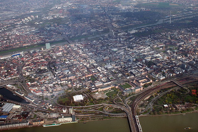
Ludwigshafen (Ludwigshafen am Rhein)

- city in Rhineland-Palatinate, Germany
 Hiking in Ludwigshafen
Ludwigshafen am Rhein, located in the German state of Rhineland-Palatinate, offers access to a variety of hiking opportunities in the surrounding areas. While the city itself is more industrial and urban, it's strategically positioned near natural attractions and hiking trails, especially along the Rhine River and in nearby forests and hills.
Hiking Opportunities Near Ludwigshafen:
-
Rhein promenade: A scenic walk along the Rhine River, the promenade provides a flat and easy trail suitable for casual walks or runs. It’s a great place to enjoy views of the river and the city’s skyline.
-
Pfälzerwald (Palatinate Forest): Located just south of Ludwigshafen, this large protected area boasts numerous marked trails with varying difficulty levels. It features beautiful woodland, rock formations, and scenic viewpoints. It’s ideal for a day hike or even multi-day trekking on longer trails like the Palatinate Forest Trail.
-
Bergstraße-Odenwald Nature Park: To the north, this park offers lovely hiking routes with picturesque landscapes, vineyards, and historic sites. The trails can range from easy walks to more challenging hikes, making it suitable for hikers of all skill levels.
-
Hiking to nearby towns: You can hike from Ludwigshafen to nearby towns such as Mannheim or even further to places like Bad Dürkheim, enjoying the vineyards and countryside along the way.
Tips for Hiking in the Area:
- Check Weather Conditions: The weather can change quickly, so always check forecasts and dress in layers.
- Stay Hydrated: Bring enough water, especially when hiking in warmer weather.
- Trail Maps: Consider downloading trail maps or using a hiking app for navigation. Well-marked trails are available, but it’s good to have a backup.
- Safety: Let someone know your hiking plans, especially if you venture into more remote areas.
Local Facilities:
- Cafés and Rest Stops: Many trails, especially in vineyard areas, have cafés or wine taverns where you can stop for refreshments.
- Public Transport: Ludwigshafen has good transport connections to nearby hiking areas, making it easy to access trailheads without needing a car.
Overall, while Ludwigshafen itself may not be a hiking hotspot, its proximity to natural areas and well-maintained trails make it an excellent base for hikers looking to explore the beautiful landscapes of the Palatinate region.
- Country:

- Postal Code: 67071; 67070; 67069; 67068; 67067; 67066; 67065; 67064; 67063; 67062; 67061; 67060; 67059
- Local Dialing Code: 06237; 0621
- Licence Plate Code: LU
- Coordinates: 49° 28' 52" N, 8° 26' 7" E


- GPS tracks (wikiloc): [Link]
- AboveSeaLevel: 96 м m
- Area: 77.43 sq km
- Population: 166621
- Web site: http://www.ludwigshafen.de
- Wikipedia en: wiki(en)
- Wikipedia: wiki(de)
- Wikidata storage: Wikidata: Q2910
- Wikipedia Commons Gallery: [Link]
- Wikipedia Commons Category: [Link]
- Wikipedia Commons Maps Category: [Link]
- Freebase ID: [/m/012j32]
- GeoNames ID: Alt: [3247910]
- BnF ID: [12312821t]
- VIAF ID: Alt: [263473089]
- OSM relation ID: [62347]
- GND ID: Alt: [4036472-0]
- archINFORM location ID: [1231]
- Library of Congress authority ID: Alt: [n80158512]
- MusicBrainz area ID: [3f73445c-fec7-4178-8e30-15d7ccb0ec36]
- Quora topic ID: [Ludwigshafen-Germany]
- SUDOC authorities ID: [032018800]
- Encyclopædia Britannica Online ID: [place/Ludwigshafen]
- Facebook Places ID: [108038255891719]
- Great Russian Encyclopedia Online ID: [2161848]
- ISNI: Alt: [0000 0001 1956 8825]
- National Library of Israel ID: [000982282]
- NUTS code: [DEB34]
- Klexikon article ID: [Ludwigshafen_am_Rhein]
- Ringgold ID: [373757]
- Global Anabaptist Mennonite Encyclopedia Online ID: [Ludwigshafen (Rhineland-Pfalz, Germany)]
- German municipality key: 07314000
- US National Archives Identifier: 10045624
- German district key: 07314
Includes regions:
Ludwigshafen-Nördliche Innenstadt
- human settlement in Germany
Hiking in Ludwigshafen-Nördliche Innenstadt
Ludwigshafen-Nördliche Innenstadt, located in Germany’s Rhineland-Palatinate region, is primarily an urban area, so traditional hiking opportunities may be limited compared to more rural or natural settings. However, you can still enjoy walking, exploring green spaces, and engaging in activities that blend urban and nature experiences....
- Country:
- Coordinates: 49° 29' 10" N, 8° 26' 10" E
- GPS tracks (wikiloc): [Link]
Friesenheim
- Ortsteil of Ludwigshafen am Rhein
Hiking in Friesenheim
Ludwigshafen-Friesenheim, located in the Rhineland-Palatinate region of Germany, is primarily an urban area, but it also provides opportunities for outdoor activities including hiking. While the local environment may not offer extensive mountain trails, there are several nearby green spaces and routes that can be explored....
- Country:
- Coordinates: 49° 29' 45" N, 8° 24' 57" E
- GPS tracks (wikiloc): [Link]
Ludwigshafen-Gartenstadt
- human settlement in Germany
Hiking in Ludwigshafen-Gartenstadt
Ludwigshafen-Gartenstadt is a delightful area located in Germany, specifically in the state of Rhineland-Palatinate. While it may not be as famous for its hiking trails as some of the surrounding regions, it still offers opportunities for outdoor enthusiasts to enjoy nature and some scenic walks....
- Country:
- Coordinates: 49° 27' 42" N, 8° 24' 17" E
- GPS tracks (wikiloc): [Link]
Ludwigshafen-Südliche Innenstadt
- human settlement in Germany
Hiking in Ludwigshafen-Südliche Innenstadt
Ludwigshafen-Südliche Innenstadt is primarily an urban area in the city of Ludwigshafen am Rhein, Germany, which is known for its industrial backdrop rather than hiking trails or natural landscapes. However, there are options for those looking to enjoy outdoor activities nearby....
- Country:
- Coordinates: 49° 28' 17" N, 8° 26' 46" E
- GPS tracks (wikiloc): [Link]


Mundenheim
- human settlement in Germany
Hiking in Mundenheim
Mundenheim is a small district within the city of Ludwigshafen in Germany. While it may not be extensively known for its hiking trails compared to larger natural parks or mountainous regions, there are still opportunities for outdoor enthusiasts to explore and enjoy nature in the surrounding areas....
- Country:
- Coordinates: 49° 27' 41" N, 8° 25' 36" E
- GPS tracks (wikiloc): [Link]
Oggersheim
- Ortsteil of Ludwigshafen am Rhein
Hiking in Oggersheim
Oggersheim, a district of Ludwigshafen in the Rhineland-Palatinate region of Germany, is surrounded by beautiful landscapes that are perfect for hiking enthusiasts. While Oggersheim itself is more urban, there are several nearby natural areas where you can enjoy hiking....
- Country:
- Postal Code: 67071
- Coordinates: 49° 29' 27" N, 8° 22' 29" E
- GPS tracks (wikiloc): [Link]
- Area: 11.38 sq km
Ludwigshafen-Oppau
- human settlement in Germany
Hiking in Ludwigshafen-Oppau
Ludwigshafen-Oppau, located in the German state of Rhineland-Palatinate, offers a variety of hiking opportunities suited for different skill levels. While it may not be as famous for its hiking trails as some other regions in Germany, the area does have its attractions and scenic routes that can make for an enjoyable day outdoors....
- Country:
- Coordinates: 49° 31' 12" N, 8° 24' 7" E
- GPS tracks (wikiloc): [Link]
Ruchheim
- western suburb of Ludwigshafen am Rhein, Germany
Hiking in Ruchheim
Ruchheim, a district of the city of Ludwigshafen in Germany, is not primarily known as a hiking destination, but it does offer some opportunities for outdoor activities and walking. The surrounding region of the Rhine-Palatinate offers a range of hiking trails that you can explore if you venture a bit further....
- Country:
- Coordinates: 49° 28' 0" N, 8° 20' 0" E
- GPS tracks (wikiloc): [Link]
Maudach
- district of Ludwigshafen
Hiking in Maudach
Maudach is a picturesque area that offers several hiking opportunities. Although it's not as widely known as some larger hiking regions, it has charm and accessibility, making it a great spot for outdoor enthusiasts....
- Country:
- Coordinates: 49° 27' 15" N, 8° 22' 46" E
- GPS tracks (wikiloc): [Link]
Rheingöheim
- human settlement in Germany
Hiking in Rheingöheim
Rheingönheim, a district of Ludwigshafen am Rhein in Germany, offers picturesque landscapes ideal for hiking enthusiasts. While it may not be as widely known as some larger hiking areas, there are still plenty of opportunities to enjoy nature and explore the trails in and around the area. Here are some key points for hiking in Rheingönheim:...
- Country:
- Coordinates: 49° 26' 48" N, 8° 25' 9" E
- GPS tracks (wikiloc): [Link]
Shares border with regions:

Mannheim
- city in Baden-Württemberg, Germany
Hiking in Mannheim
Mannheim, located in southwestern Germany, is not typically known as a hiking destination compared to some of the more mountainous regions of the country. However, it does offer some pleasant walking and hiking opportunities, particularly along the Rhine and Neckar rivers. Here are some options for hiking in and around Mannheim:...
- Country:
- Postal Code: 68309; 68307; 68305; 68259; 68239; 68229; 68219; 68199; 68169; 68167; 68165; 68163; 68161; 68159
- Local Dialing Code: 0621
- Licence Plate Code: MA
- Coordinates: 49° 29' 1" N, 8° 27' 47" E
- GPS tracks (wikiloc): [Link]
- AboveSeaLevel: 97 м m
- Area: 144.97 sq km
- Population: 304781
- Web site: [Link]


Frankenthal
- town in Rhineland-Palatinate, Germany
Hiking in Frankenthal
Frankenthal, a city located in the Rhineland-Palatinate region of Germany, is not primarily known for hiking compared to more mountainous areas of the country. However, it offers several opportunities for walking and hiking enthusiasts, particularly in the surrounding nature areas and the nearby Palatinate Forest....
- Country:
- Postal Code: 67227
- Local Dialing Code: 06233
- Licence Plate Code: FT
- Coordinates: 49° 32' 0" N, 8° 21' 0" E
- GPS tracks (wikiloc): [Link]
- AboveSeaLevel: 96 м m
- Area: 43.88 sq km
- Population: 48445
- Web site: [Link]

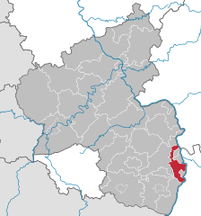
Rhein-Pfalz-Kreis
- district of Rhineland-Palatinate, Germany
Hiking in Rhein-Pfalz-Kreis
Rhein-Pfalz-Kreis, located in the state of Rhineland-Palatinate in Germany, is a fantastic area for hiking enthusiasts. With its picturesque landscapes, rolling hills, vineyards, and charming villages, this region offers a variety of trails suitable for all skill levels. Here’s an overview of what you can expect when hiking in Rhein-Pfalz-Kreis:...
- Country:
- Capital: Ludwigshafen
- Licence Plate Code: RP
- Coordinates: 49° 25' 12" N, 8° 19' 48" E
- GPS tracks (wikiloc): [Link]
- AboveSeaLevel: 95 м m
- Web site: [Link]