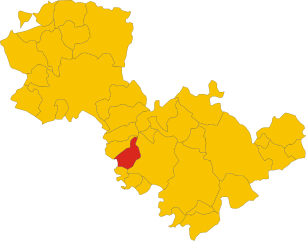
Lugnano in Teverina (Lugnano in Teverina)
- town in the region Umbria, Italy
Lugnano in Teverina is a charming medieval town located in the province of Terni, in the Umbria region of central Italy. Surrounded by beautiful landscapes, rolling hills, and lush countryside, it offers a range of opportunities for hiking and outdoor activities.
Hiking Opportunities:
-
Trail Variety: The area boasts various trails that cater to different experience levels. Whether you're an experienced hiker or a beginner, you'll find routes that suit your preference.
-
Scenic Landscapes: Many trails in the region provide stunning views of the surrounding hills, vineyards, and the Tevere River valley. The natural beauty of the area, with its diverse flora and fauna, makes for a rewarding hiking experience.
-
Historical Sites: Hiking around Lugnano can also lead you to several historical landmarks, such as ancient churches and ruins, adding a cultural element to your outdoor adventures. The town itself has a rich history reflected in its architecture and surroundings.
-
Nature Reserves: Nearby nature reserves and protected areas offer well-marked trails that allow hikers to immerse themselves in Umbria's natural beauty. Keep an eye out for local wildlife, particularly birds, as the area is home to a variety of species.
-
Seasonal Hiking: Spring and autumn are ideal seasons for hiking in this area due to the mild weather. In spring, you'll witness blooming wildflowers, while autumn offers vibrant fall foliage.
Tips for Hiking in Lugnano in Teverina:
-
Join Local Guides: Consider joining a local hiking group or hiring a guide to enhance your experience. They can provide insights into the area's history, culture, and natural environment.
-
Check Maps and Resources: Before heading out, acquire trail maps or use a reliable hiking app to navigate the trails safely.
-
Stay Hydrated and Prepared: Carry plenty of water, wear sturdy hiking boots, and pack snacks. It's also important to dress appropriately for the weather.
-
Respect Nature: Follow the Leave No Trace principles to preserve the environment. Stay on marked trails and dispose of waste properly.
Whether you're looking for a leisurely walk or a more challenging hike, Lugnano in Teverina offers a beautiful setting for exploring Italy’s stunning Umbria region on foot.
- Country:

- Postal Code: 05020
- Local Dialing Code: 0744
- Licence Plate Code: TR
- Coordinates: 42° 34' 0" N, 12° 20' 0" E


- GPS tracks (wikiloc): [Link]
- AboveSeaLevel: 419 м m
- Area: 29.83 sq km
- Population: 1453
- Web site: http://lnx.comunedilugnano.it/lugnano/modules/content/home.php
- Wikipedia en: wiki(en)
- Wikipedia: wiki(it)
- Wikidata storage: Wikidata: Q10823
- Wikipedia Commons Category: [Link]
- Freebase ID: [/m/0gm314]
- GeoNames ID: Alt: [6541118]
- BnF ID: [13740724j]
- VIAF ID: Alt: [150422630]
- OSM relation ID: [42076]
- GND ID: Alt: [4674510-5]
- Library of Congress authority ID: Alt: [no99067206]
- TGN ID: [7005147]
- Facebook Places ID: [105963789434684]
- Digital Atlas of the Roman Empire ID: [35745]
- ISTAT ID: 055016
- Italian cadastre code: E729
Shares border with regions:


Graffignano
- Italian comune
Graffignano is a charming town located in the province of Viterbo in the Lazio region of Italy. Surrounded by beautiful natural landscapes, it offers various hiking opportunities for outdoor enthusiasts looking to explore the Italian countryside....
- Country:

- Postal Code: 01020
- Local Dialing Code: 0761
- Licence Plate Code: VT
- Coordinates: 42° 34' 24" N, 12° 12' 9" E


- GPS tracks (wikiloc): [Link]
- AboveSeaLevel: 187 м m
- Area: 29.1 sq km
- Population: 2226
- Web site: [Link]


Alviano
- town in the region Umbria, in Italy
Alviano, located in the Umbria region of Italy, is known for its beautiful landscapes and natural parks, making it a great spot for hiking enthusiasts. The area is characterized by scenic hills, olive groves, and views of the Tiber River, creating a picturesque backdrop for outdoor activities....
- Country:

- Postal Code: 05020
- Local Dialing Code: 0744
- Licence Plate Code: TR
- Coordinates: 42° 35' 0" N, 12° 18' 0" E


- GPS tracks (wikiloc): [Link]
- AboveSeaLevel: 251 м m
- Area: 23.9 sq km
- Population: 1451
- Web site: [Link]

Amelia
- town in the region Umbria, in Italy
Hiking in Amelia, Umbria, is a wonderful way to explore the natural beauty and rich history of the region. Amelia is situated in a picturesque area that offers a variety of trails, ranging from easy walks through gentle landscapes to more challenging hikes that lead to stunning viewpoints and historical sites....
- Country:

- Postal Code: 05022
- Local Dialing Code: 0744
- Licence Plate Code: TR
- Coordinates: 42° 33' 6" N, 12° 25' 15" E


- GPS tracks (wikiloc): [Link]
- AboveSeaLevel: 406 м m
- Area: 132.5 sq km
- Population: 11828
- Web site: [Link]


Attigliano
- town in the region Umbria, in Italy
Attigliano is a small town in the province of Terni, located in the Umbria region of Italy. While not as widely known for hiking as some other areas in Italy, it does offer access to beautiful landscapes and trails in the surrounding areas. Here are some aspects of hiking near Attigliano:...
- Country:

- Postal Code: 05012
- Local Dialing Code: 0744
- Licence Plate Code: TR
- Coordinates: 42° 31' 0" N, 12° 18' 0" E


- GPS tracks (wikiloc): [Link]
- AboveSeaLevel: 95 м m
- Area: 10.51 sq km
- Population: 1991
- Web site: [Link]

