Lumeau (Lumeau)

- commune in Eure-et-Loir, France
- Country:

- Postal Code: 28140
- Coordinates: 48° 6' 57" N, 1° 47' 8" E


- GPS tracks (wikiloc): [Link]
- AboveSeaLevel: 122 м m
- Area: 15.28 sq km
- Population: 171
- Wikipedia en: wiki(en)
- Wikipedia: wiki(fr)
- Wikidata storage: Wikidata: Q1139455
- Wikipedia Commons Category: [Link]
- Freebase ID: [/m/03nqvcq]
- GeoNames ID: Alt: [6430785]
- SIREN number: [212802219]
- BnF ID: [15254151c]
- INSEE municipality code: 28221
Shares border with regions:

Loigny-la-Bataille
- commune in Eure-et-Loir, France
- Country:
- Postal Code: 28140
- Coordinates: 48° 7' 23" N, 1° 43' 59" E
- GPS tracks (wikiloc): [Link]
- Area: 18.05 sq km
- Population: 209


Sougy
- commune in Loiret, France
- Country:
- Postal Code: 45410
- Coordinates: 48° 3' 13" N, 1° 47' 23" E
- GPS tracks (wikiloc): [Link]
- Area: 28.25 sq km
- Population: 845


Tillay-le-Péneux
- commune in Eure-et-Loir, France
- Country:
- Postal Code: 28140
- Coordinates: 48° 9' 36" N, 1° 46' 29" E
- GPS tracks (wikiloc): [Link]
- Area: 22.19 sq km
- Population: 328
Terminiers
- commune in Eure-et-Loir, France
- Country:
- Postal Code: 28140
- Coordinates: 48° 4' 57" N, 1° 44' 23" E
- GPS tracks (wikiloc): [Link]
- Area: 31.72 sq km
- Population: 926

Baigneaux
- commune in Gironde, France
- Country:
- Postal Code: 33760
- Coordinates: 44° 43' 22" N, 0° 11' 49" E
- GPS tracks (wikiloc): [Link]
- Area: 7.93 sq km
- Population: 410

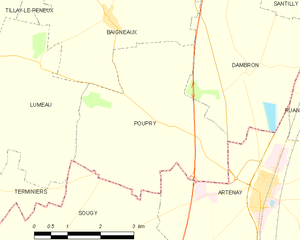
Poupry
- commune in Eure-et-Loir, France
- Country:
- Postal Code: 28140
- Coordinates: 48° 5' 58" N, 1° 50' 19" E
- GPS tracks (wikiloc): [Link]
- Area: 14.48 sq km
- Population: 107
- Web site: [Link]