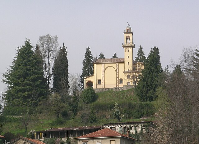
Lurate Caccivio (Lurate Caccivio)
- Italian comune
Lurate Caccivio, a small town located near Como in the Lombardy region of Italy, offers a range of hiking opportunities that cater to various skill levels. While the immediate area might not have the extensive trails found in larger parks, it serves as a great base for exploring nearby natural attractions.
Nearby Hiking Opportunities:
-
Spina Verde Regional Park: Just a short distance from Lurate Caccivio, this beautiful park features several well-marked trails that wind through lush forests and offer stunning views of Lake Como and the surrounding landscape. The trails vary in difficulty, making it suitable for both casual walkers and more experienced hikers.
-
Monte Olimpino: This mountain is accessible from near Lurate Caccivio and provides a rewarding hike with panoramic views of the city of Como and Lake Como. The trails here can be steep in sections, so it's advisable to have a good level of fitness.
-
Via dei Monti Lariani: A famous long-distance trail that runs along the eastern shore of Lake Como. While it's a bit farther from Lurate Caccivio, you can access segments of this trail for a day hike. It features breathtaking views of mountains and the lake.
Tips for Hiking in the Area:
-
Weather Considerations: Always check the weather before heading out, as conditions can change rapidly in the mountains.
-
Footwear: Wear sturdy hiking boots to navigate the varied terrain safely.
-
Water and Snacks: Carry enough water and some snacks, especially for longer hikes.
-
Navigation: It's helpful to have a map or GPS device, especially on less-marked trails.
-
Local Advice: Don’t hesitate to ask locals for trail recommendations or any updates on trail conditions.
Final Notes:
Hiking in and around Lurate Caccivio allows you to experience the stunning natural beauty of Northern Italy. Whether you're looking for a leisurely walk or an adventurous trek, you'll find something that fits your needs. Enjoy your hike!
- Country:

- Postal Code: 22075
- Local Dialing Code: 031
- Licence Plate Code: CO
- Coordinates: 45° 46' 0" N, 9° 0' 0" E


- GPS tracks (wikiloc): [Link]
- AboveSeaLevel: 330 м m
- Area: 5.93 sq km
- Population: 9847
- Web site: http://www.comune.luratecaccivio.co.it
- Wikipedia en: wiki(en)
- Wikipedia: wiki(it)
- Wikidata storage: Wikidata: Q47346
- Wikipedia Commons Category: [Link]
- Freebase ID: [/m/0gj0tx]
- GeoNames ID: Alt: [3174436]
- VIAF ID: Alt: [242766273]
- OSM relation ID: [45985]
- Quora topic ID: [Lurate-Caccivio]
- UN/LOCODE: [ITLCA]
- ISTAT ID: 013138
- Italian cadastre code: E753
Shares border with regions:
Appiano Gentile
- Italian comune
Appiano Gentile is a charming town located in the province of Como, in the Lombardy region of northern Italy. While it might not be as widely known for hiking as some areas near the Alps, there are several beautiful trails and scenic spots in and around Appiano Gentile that can offer a lovely hiking experience....
- Country:

- Postal Code: 22070
- Local Dialing Code: 031
- Licence Plate Code: CO
- Coordinates: 45° 44' 18" N, 8° 58' 47" E


- GPS tracks (wikiloc): [Link]
- AboveSeaLevel: 366 м m
- Area: 12.81 sq km
- Population: 7750
- Web site: [Link]
Bulgarograsso
- Italian comune
Bulgarograsso is a small town in the Lombardy region of northern Italy, located close to the city of Como. While it is not widely known as a hiking destination, you can still enjoy the natural beauty of the surrounding areas. Here's some information for hiking enthusiasts looking to explore near Bulgarograsso:...
- Country:

- Postal Code: 22070
- Local Dialing Code: 031
- Licence Plate Code: CO
- Coordinates: 45° 45' 0" N, 9° 0' 0" E


- GPS tracks (wikiloc): [Link]
- AboveSeaLevel: 317 м m
- Area: 3.77 sq km
- Population: 4054
- Web site: [Link]
Villa Guardia
- Italian comune
Villa Guardia is a charming town located in the province of Como, in northern Italy. It is surrounded by scenic landscapes, making it a great spot for hiking enthusiasts. Here are some highlights and considerations for hiking in and around Villa Guardia:...
- Country:

- Postal Code: 22079
- Local Dialing Code: 031
- Licence Plate Code: CO
- Coordinates: 45° 47' 0" N, 9° 1' 0" E


- GPS tracks (wikiloc): [Link]
- AboveSeaLevel: 350 м m
- Area: 7.87 sq km
- Population: 8041
- Web site: [Link]
Olgiate Comasco
- Italian comune
Olgiate Comasco is a charming town located in the Lombardy region of Italy, close to the border with Switzerland. It offers access to various hiking opportunities, particularly in the surrounding natural landscapes that include hills, lakes, and forested areas. Here are some highlights and tips for hiking in and around Olgiate Comasco:...
- Country:

- Postal Code: 22077
- Local Dialing Code: 031
- Licence Plate Code: CO
- Coordinates: 45° 47' 0" N, 8° 58' 0" E


- GPS tracks (wikiloc): [Link]
- AboveSeaLevel: 400 м m
- Area: 10.96 sq km
- Population: 11633
- Web site: [Link]


Oltrona di San Mamette
- Italian comune
 Hiking in Oltrona di San Mamette
Oltrona di San Mamette, a small town located in the province of Como in Italy, is surrounded by beautiful natural landscapes that offer various hiking opportunities. The area is characterized by its lush vegetation, scenic views of the surrounding hills and mountains, and the proximity to the beautiful Lake Como....
- Country:

- Postal Code: 22070
- Local Dialing Code: 031
- Licence Plate Code: CO
- Coordinates: 45° 45' 23" N, 8° 58' 36" E


- GPS tracks (wikiloc): [Link]
- AboveSeaLevel: 370 м m
- Area: 2.69 sq km
- Population: 2397
- Web site: [Link]
