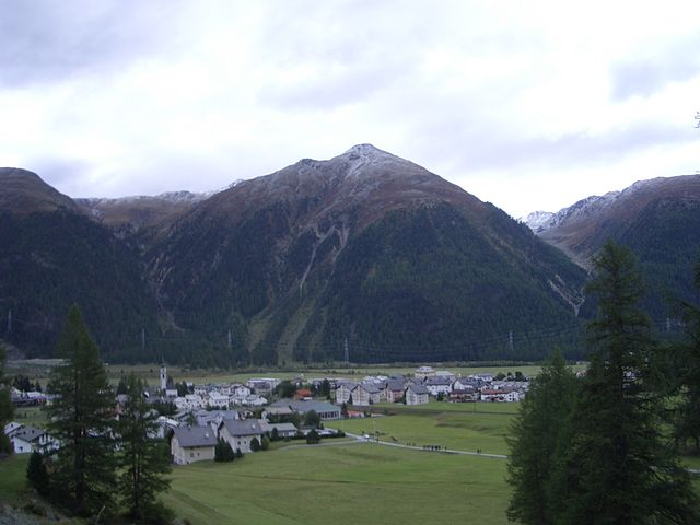
Madulain (Madulain)
- municipality in Switzerland
Madulain is a picturesque village located in the Engadine Valley of Switzerland, known for its stunning landscapes and opportunities for hiking. Nestled at an altitude of about 1,400 meters (4,600 feet), it serves as an excellent base for exploring the surrounding natural beauty. Here are some highlights related to hiking in and around Madulain:
Hiking Trails
-
Local Trails: There are numerous well-maintained trails starting directly from Madulain. The routes offer varying difficulty levels, catering to both casual walkers and experienced hikers. You can enjoy scenic views of the surrounding mountains and the lush valley.
-
Landwasser Valley: One popular hike is along the Landwasser River, where you can take in the lush green valleys, unique rock formations, and other stunning landscapes. The trail often leads to various viewpoints with breathtaking vistas.
-
Culinary Hiking: Some trails are designated for culinary hikes, where hikers can stop at local restaurants or huts to taste authentic Engadine dishes such as Capuns (Swiss chard with a filling) or Pizokel (pasta-like dish).
-
Higher Elevation Trails: For more challenging hikes, consider trails that lead into the higher elevations of the Alps. You can hike towards peaks like Piz Languard or Piz Ot. These trails offer more demanding terrain and provide fantastic panoramic views.
-
Fluelapass: A classic hike that can be undertaken is the route over the Fluelapass, connecting Madulain with other valleys, offering a taste of the alpine experience.
Seasonal Considerations
- Summer: The best time for hiking in the region is from late May to October when the weather is generally mild, and the trails are clear of snow.
- Winter: While summer is prime hiking season, winter trekking and snowshoeing are also popular in the area. Check local conditions and whether trails are open.
Essential Tips
- Maps and Signage: Familiarize yourself with the hiking map available at local tourism offices or online resources. The trails are well-marked, but it's always good to have a reliable map on hand.
- Safety: Ensure you have suitable hiking gear, including sturdy footwear, weather-appropriate clothing, and enough water and snacks. Always inform someone about your hiking plans and expected return time, especially on longer hikes.
Madulain offers a mix of tranquility and adventure, making it a delightful place for hiking enthusiasts. Whether you're seeking leisurely walks or challenging treks, you're guaranteed to enjoy the breathtaking scenery and the charm of the Engadine region.
- Country:

- Postal Code: 7523
- Local Dialing Code: 081
- Licence Plate Code: GR
- Coordinates: 46° 32' 46" N, 9° 57' 57" E


- GPS tracks (wikiloc): [Link]
- AboveSeaLevel: 2270 м m
- Area: 16.28 sq km
- Population: 209
- Web site: http://www.madulain.ch
- Wikipedia en: wiki(en)
- Wikipedia: wiki(de)
- Wikidata storage: Wikidata: Q66638
- Wikipedia Commons Gallery: [Link]
- Wikipedia Commons Category: [Link]
- Freebase ID: [/m/0csxpk]
- GeoNames ID: Alt: [7286413]
- VIAF ID: Alt: [237454665]
- OSM relation ID: [1684109]
- GND ID: Alt: [4610733-2]
- HDS ID: [1539]
- Swiss municipality code: [3783]
Shares border with regions:


S-chanf
- municipality in Switzerland
S-chanf, a picturesque village located in the Engadin Valley of Switzerland, offers a variety of hiking opportunities for outdoor enthusiasts of all skill levels. Here are some aspects to consider when hiking in this beautiful area:...
- Country:

- Postal Code: 7525
- Local Dialing Code: 081
- Licence Plate Code: GR
- Coordinates: 46° 36' 59" N, 9° 59' 0" E


- GPS tracks (wikiloc): [Link]
- AboveSeaLevel: 1878 м m
- Area: 138.03 sq km
- Population: 685
- Web site: [Link]


La Punt-Chamues-ch
- municipality in Switzerland
La Punt-Chamues-ch is a picturesque village located in the Engadin valley of Switzerland, known for its stunning landscapes, traditional architecture, and excellent hiking opportunities. Here are some key aspects to consider when hiking in this beautiful region:...
- Country:

- Postal Code: 7522
- Local Dialing Code: 081
- Licence Plate Code: GR
- Coordinates: 46° 33' 59" N, 9° 54' 59" E


- GPS tracks (wikiloc): [Link]
- AboveSeaLevel: 1687 м m
- Area: 63.27 sq km
- Population: 712
- Web site: [Link]


Zuoz
- municipality in Switzerland
Zuoz, a charming village in the Engadin Valley of Switzerland, offers stunning landscapes and a variety of hiking options for all skill levels. The area is renowned for its natural beauty, with majestic mountains, lush forests, and scenic meadows....
- Country:

- Postal Code: 7524
- Local Dialing Code: 081
- Licence Plate Code: GR
- Coordinates: 46° 36' 7" N, 9° 57' 35" E


- GPS tracks (wikiloc): [Link]
- AboveSeaLevel: 1718 м m
- Area: 65.79 sq km
- Population: 1207
- Web site: [Link]


Bever
- municipality in Graubünden, Switzerland
Bever, Switzerland, is a charming village located in the Engadin Valley and is part of the UNESCO Biosphere Reserve. It offers incredible hiking opportunities amidst stunning alpine scenery, making it an attractive destination for both novice and seasoned hikers. Here are some key details about hiking in Bever:...
- Country:

- Postal Code: 7502
- Local Dialing Code: 081
- Licence Plate Code: GR
- Coordinates: 46° 32' 59" N, 9° 52' 59" E


- GPS tracks (wikiloc): [Link]
- AboveSeaLevel: 2653 м m
- Area: 47.75 sq km
- Population: 598
- Web site: [Link]


Pontresina
- village in the Engadine valley, Graubünden, Switzerland
Pontresina is a picturesque mountain village located in the Engadin valley of Switzerland, known for its stunning landscapes, diverse hiking trails, and proximity to the Bernina Range. Here are some key points about hiking in Pontresina:...
- Country:

- Postal Code: 7504
- Local Dialing Code: 081
- Licence Plate Code: GR
- Coordinates: 46° 26' 28" N, 9° 57' 27" E


- GPS tracks (wikiloc): [Link]
- AboveSeaLevel: 2446 м m
- Area: 118.19 sq km
- Population: 2195
- Web site: [Link]

