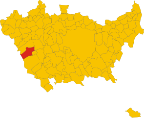
Magenta (Magenta)
.svg)
- Italian comune
 Hiking in Magenta
Magenta, located in the Lombardy region of Italy, is a town rich in history and natural surroundings, though it may not be as well-known for hiking as other destinations in the region like the Alps or Lake Como. However, there are still opportunities to enjoy the outdoors and engage in hiking in and around Magenta.
Nearby Nature and Trails
-
Parco del Ticino: One of the most notable natural areas near Magenta is the Ticino Park (Parco Lombardo della Valle del Ticino). This regional park features various hiking trails that wind through beautiful countryside, forests, and along the Ticino River. The trails often offer a mix of easy walks and more demanding paths, catering to different levels of hikers.
-
Local Trails: Within and around Magenta, you might find smaller local trails that take you through fields, along canals, and through wooded areas. These can be perfect for casual walks and birdwatching.
-
Cycling Routes: While not strictly hiking, the area also offers cycling routes that are often shared with hikers, providing an opportunity to explore more of the scenic landscape around Magenta.
Planning Your Hike
-
Best Time to Visit: Late spring and early autumn are excellent times for hiking, with pleasant temperatures and blooming nature. Summer can be hot, while winter may bring lower temperatures.
-
What to Bring: Ensure you dress appropriately for the weather with good hiking shoes, and carry water, snacks, a map or GPS, and a first aid kit.
-
Local Amenities: Magenta has various local amenities including cafes and restaurants where you can enjoy local cuisine after your hike.
-
Accessibility: Many of the trails and parks are accessible via public transport if you want to travel from Magenta to more extensive hiking areas.
Cultural Aspects
The area around Magenta is steeped in history, so while hiking, take the time to explore local historical sites, such as the Basilica di San Martino or Villa Commenda, which add a cultural dimension to your outdoor adventures.
In summary, while Magenta itself may not be a hotbed of hiking activity, its proximity to natural parks and charming landscapes allows for a range of outdoor activities, making it a pleasant adventure base in Lombardy.
- Country:

- Postal Code: 20013
- Local Dialing Code: 02
- Licence Plate Code: MI
- Coordinates: 45° 28' 0" N, 8° 53' 0" E


- GPS tracks (wikiloc): [Link]
- AboveSeaLevel: 138 м m
- Area: 21.99 sq km
- Population: 23845
- Web site: http://www.comunedimagenta.it
- Wikipedia en: wiki(en)
- Wikipedia: wiki(it)
- Wikidata storage: Wikidata: Q42595
- Wikipedia Commons Category: [Link]
- Freebase ID: [/m/01d56c]
- GeoNames ID: Alt: [6536515]
- VIAF ID: Alt: [239173901]
- OSM relation ID: [45010]
- archINFORM location ID: [16314]
- MusicBrainz area ID: [3355cd2d-e299-4593-adb5-c6b33463a9d0]
- UN/LOCODE: [ITMGA]
- Encyclopædia Britannica Online ID: [place/Magenta-Italy]
- ISTAT ID: 015130
- Italian cadastre code: E801
Shares border with regions:

Cerano
- Italian comune
Hiking in Cerano
Cerano is a charming village located in the Piedmont region of Italy, specifically in the province of Novara. While it may not be as well-known as other hiking destinations, the surrounding areas offer picturesque landscapes and opportunities for outdoor activities....
- Country:
- Postal Code: 28065
- Local Dialing Code: 0321
- Licence Plate Code: NO
- Coordinates: 45° 24' 0" N, 8° 47' 0" E
- GPS tracks (wikiloc): [Link]
- AboveSeaLevel: 134 м m
- Area: 32.64 sq km
- Population: 6813
- Web site: [Link]

Trecate
- Italian comune
Hiking in Trecate
Trecate is a town in the Piedmont region of northern Italy, located near the larger city of Novara. While Trecate itself may not be a primary hiking destination, the surrounding areas offer several interesting possibilities for outdoor activities and hiking excursions....
- Country:
- Postal Code: 28069
- Local Dialing Code: 0321
- Licence Plate Code: NO
- Coordinates: 45° 26' 0" N, 8° 44' 0" E
- GPS tracks (wikiloc): [Link]
- AboveSeaLevel: 136 м m
- Area: 38.22 sq km
- Population: 20566
- Web site: [Link]


Marcallo con Casone
- Italian comune
Hiking in Marcallo con Casone
Marcallo con Casone is a small municipality in the Lombardy region of Italy, near Milan. While it may not be the most famous hiking destination in Italy, it has its own charm and offers some opportunities for outdoor activities. Here are some insights on hiking in and around Marcallo con Casone:...
- Country:
- Postal Code: 20010
- Local Dialing Code: 02
- Licence Plate Code: MI
- Coordinates: 45° 29' 53" N, 8° 52' 35" E
- GPS tracks (wikiloc): [Link]
- AboveSeaLevel: 147 м m
- Area: 8.21 sq km
- Population: 6254
- Web site: [Link]


Boffalora sopra Ticino
- Italian comune
Hiking in Boffalora sopra Ticino
Boffalora sopra Ticino is a charming village located in the Lombardy region of Italy, near the banks of the Ticino River. It offers a variety of hiking and outdoor opportunities for nature enthusiasts. Here are some highlights and tips for hiking in the area:...
- Country:
- Postal Code: 20010
- Local Dialing Code: 02
- Licence Plate Code: MI
- Coordinates: 45° 28' 0" N, 8° 50' 0" E
- GPS tracks (wikiloc): [Link]
- AboveSeaLevel: 120 м m
- Area: 7.65 sq km
- Population: 4113
- Web site: [Link]

Robecco sul Naviglio
- Italian comune
Hiking in Robecco sul Naviglio
Robecco sul Naviglio is a charming town located in the Lombardy region of Italy, near the banks of the Naviglio Grande canal. While it's not a major hiking destination compared to some of the larger Italian national parks, it does offer some pleasant walking and hiking opportunities, especially along the waterways and in the surrounding rural landscapes....
- Country:
- Postal Code: 20087
- Local Dialing Code: 02
- Licence Plate Code: MI
- Coordinates: 45° 26' 0" N, 8° 53' 0" E
- GPS tracks (wikiloc): [Link]
- AboveSeaLevel: 120 м m
- Area: 19.79 sq km
- Population: 6766
- Web site: [Link]


Corbetta
- Italian comune
Hiking in Corbetta
Corbetta, located in the Lombardy region of Italy, offers a range of opportunities for outdoor enthusiasts, albeit it's not as well-known for hiking as some of the more mountainous areas in Italy. However, it is situated in the proximity of several natural parks and trails that can make for enjoyable hiking experiences....
- Country:
- Postal Code: 20011
- Local Dialing Code: 02
- Licence Plate Code: MI
- Coordinates: 45° 28' 0" N, 8° 55' 0" E
- GPS tracks (wikiloc): [Link]
- AboveSeaLevel: 140 м m
- Area: 18.69 sq km
- Population: 18366
- Web site: [Link]


Santo Stefano Ticino
- Italian comune
Hiking in Santo Stefano Ticino
Santo Stefano Ticino is a charming municipality located in the metropolitan area of Milan, Italy. While it's not widely known for rugged hiking trails like some of the more mountainous regions of Italy, it offers a few opportunities for pleasant walks in a picturesque setting....
- Country:
- Postal Code: 20010
- Local Dialing Code: 02
- Licence Plate Code: MI
- Coordinates: 45° 29' 0" N, 8° 55' 0" E
- GPS tracks (wikiloc): [Link]
- AboveSeaLevel: 152 м m
- Area: 5.01 sq km
- Population: 4954
- Web site: [Link]