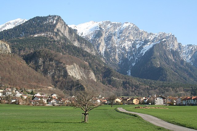
Maladers (Maladers)

- municipality in Switzerland
 Hiking in Maladers
Maladers, located near the beautiful region of Graubünden in Switzerland, is an excellent destination for hiking enthusiasts. The area offers stunning views of the surrounding mountains, lush valleys, and a variety of trails suitable for different skill levels.
Hiking Trails
-
Local Trails: Many well-marked trails lead through picturesque landscapes, offering routes that can range from easy walks suitable for families to more challenging hikes for experienced trekkers.
-
Scenic Routes: Some trails provide breathtaking views of the Alps, where you can enjoy the sight of snow-capped peaks, crystal-clear lakes, and charming alpine meadows.
-
Nature Walks: Look for trails that feature diverse flora and fauna, allowing hikers to experience the natural beauty of the region up close.
Tips for Hiking in Maladers
- Trail Maps: Always carry a trail map or download a hiking app to stay oriented.
- Weather Awareness: Check the weather forecast before your hike, as conditions can change rapidly in the mountains.
- Equipment: Wear sturdy hiking boots, bring plenty of water, snacks, and sunscreen, and consider trekking poles for steep sections.
- Guided Hikes: If you're unfamiliar with the area, consider joining a guided hike to learn more about the local ecology and history.
Best Seasons
- Summer and Early Fall: The prime hiking season is usually from late spring to early fall, when the trails are clear of snow and the weather is mild.
Nearby Attractions
- Explore the nearby towns and villages, such as the historical town of Chur, where you can find cultural attractions and delightful local cuisine.
Overall, hiking in Maladers combines breathtaking scenery, a variety of trails, and an opportunity to connect with nature, making it a fantastic choice for outdoor lovers. Be sure to respect nature and follow local guidelines to ensure a safe and enjoyable experience.
- Country:

- Postal Code: 7026
- Local Dialing Code: 081
- Licence Plate Code: GR
- Coordinates: 46° 50' 41" N, 9° 34' 20" E


- GPS tracks (wikiloc): [Link]
- AboveSeaLevel: 1353 м m
- Area: 7.59 sq km
- Population: 505
- Web site: http://www.maladers.ch
- Wikipedia en: wiki(en)
- Wikipedia: wiki(de)
- Wikidata storage: Wikidata: Q64972
- Wikipedia Commons Category: [Link]
- Freebase ID: [/m/026dyb8]
- GeoNames ID: Alt: [7286422]
- VIAF ID: Alt: [138134984]
- OSM relation ID: [1684111]
- HDS ID: [1592]
- Swiss municipality code: [3926]
- Digital Atlas of the Roman Empire ID: [17296]
- Pleiades ID: [187466]
- Lexicon istoric retic ID: [1911]
Shares border with regions:


Churwalden
- municipality in Switzerland
Hiking in Churwalden
Churwalden, located in the Prättigau Valley of Switzerland, is a fantastic destination for hiking enthusiasts. Nestled in the picturesque Graubünden region, it offers a variety of scenic trails suitable for different skill levels and preferences. Here are some details to help you plan your hiking experience in Churwalden:...
- Country:
- Postal Code: 7075
- Local Dialing Code: 081
- Licence Plate Code: GR
- Coordinates: 46° 47' 21" N, 9° 32' 20" E
- GPS tracks (wikiloc): [Link]
- AboveSeaLevel: 1159 м m
- Area: 48.54 sq km
- Population: 2012
- Web site: [Link]


Chur
- capital of the Swiss canton of Graubünden and lies in the northern part of the canton
Hiking in Chur
Chur, the capital of the Graubünden canton in Switzerland, offers a fantastic array of hiking opportunities. Nestled in the heart of the Alps, it boasts stunning landscapes that attract both beginner and experienced hikers. Here are some key highlights about hiking in and around Chur:...
- Country:
- Postal Code: 6969
- Local Dialing Code: 081
- Licence Plate Code: GR
- Coordinates: 46° 51' 8" N, 9° 31' 47" E
- GPS tracks (wikiloc): [Link]
- AboveSeaLevel: 593 м m
- Area: 28.09 sq km
- Population: 35038
- Web site: [Link]

Trimmis
- municipality in Switzerland
Hiking in Trimmis
Trimmis is a charming village located in the canton of Graubünden, Switzerland, known for its stunning landscapes and access to a variety of hiking trails. The area offers a range of hiking options that cater to different fitness levels and interests, from leisurely walks to more challenging mountain hikes....
- Country:
- Postal Code: 7203
- Local Dialing Code: 081
- Licence Plate Code: GR
- Coordinates: 46° 53' 43" N, 9° 35' 51" E
- GPS tracks (wikiloc): [Link]
- AboveSeaLevel: 1580 м m
- Area: 42.87 sq km
- Population: 3283
- Web site: [Link]