Malpas (Malpas)

- commune in Doubs, France
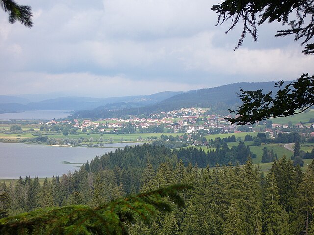
 Hiking in Malpas
Malpas, located in the Doubs department of France, is a picturesque area known for its natural beauty and outdoor activities, including hiking. The Doubs region is characterized by its varied landscapes, including rolling hills, dense forests, and the winding Doubs River. Here are some key points to consider when hiking in Malpas and its surroundings:
Trails
- Diverse Trail Options: There are various hiking trails ranging from easy walks to more challenging treks. Many trails offer beautiful views, historical sites, and opportunities to observe local wildlife.
- Marked Trails: The trails are generally well-marked, but it's always a good idea to carry a map or use a GPS to ensure you stay on the right path.
- GR (Grande Randonnée) Routes: The Doubs region features parts of the GR long-distance walking paths, which can be excellent for those looking for extended hiking experiences.
Scenic Highlights
- Natural Landscapes: Expect to see lush forests, limestone cliffs, and stunning vistas. The area also has several rivers and lakes that add to the scenic beauty.
- Historical and Cultural Sites: As you hike, you might come across charming villages, ancient churches, and historical landmarks that reflect the local culture and history.
Practical Tips
- Weather Considerations: The weather can change quickly in the mountains, so check the forecast before you head out and be prepared with layers and waterproof gear.
- Footwear: Good hiking boots are essential, especially on uneven or rocky terrain. Make sure to wear moisture-wicking socks to keep your feet dry.
- Hydration and Nutrition: Always bring enough water and snacks. There may not be places to refill during your hike.
- Wildlife Awareness: Keep an eye out for local wildlife, and be respectful of natural habitats.
Local Amenities
- Accommodations: There are various options for accommodations in the nearby towns, ranging from hotels to camping sites.
- Guided Tours: If you're unfamiliar with the area or prefer a guided experience, look for local hiking companies offering tours.
Whether you're an experienced hiker or a beginner, the trails around Malpas offer something for everyone. Be sure to take your time to enjoy the stunning scenery and the tranquility of this beautiful part of the Doubs!
- Country:

- Postal Code: 25160
- Coordinates: 46° 49' 35" N, 6° 17' 22" E


- GPS tracks (wikiloc): [Link]
- Area: 5.78 sq km
- Population: 273
- Wikipedia en: wiki(en)
- Wikipedia: wiki(fr)
- Wikidata storage: Wikidata: Q909357
- Wikipedia Commons Category: [Link]
- Freebase ID: [/m/03mgxjl]
- Freebase ID: [/m/03mgxjl]
- GeoNames ID: Alt: [6429863]
- GeoNames ID: Alt: [6429863]
- SIREN number: [212503627]
- SIREN number: [212503627]
- BnF ID: [15252588b]
- BnF ID: [15252588b]
- INSEE municipality code: 25362
- INSEE municipality code: 25362
Shares border with regions:

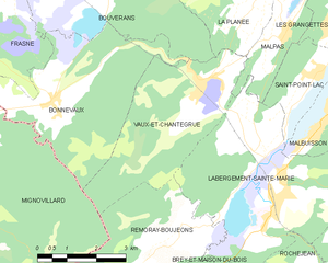
Vaux-et-Chantegrue
- commune in Doubs, France
Hiking in Vaux-et-Chantegrue
Vaux-et-Chantegrue is a charming village in the Jura region of France, known for its picturesque landscapes, rolling hills, and tranquil natural surroundings. The area offers several hiking opportunities that allow you to explore its beauty....
- Country:
- Postal Code: 25160
- Coordinates: 46° 48' 39" N, 6° 14' 59" E
- GPS tracks (wikiloc): [Link]
- Area: 13.98 sq km
- Population: 544

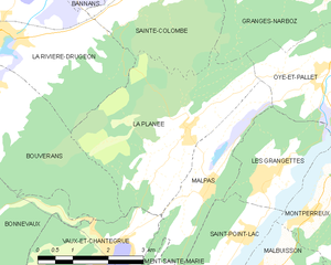
La Planée
- commune in Doubs, France
Hiking in La Planée
Hiking in La Planée, located in the French Alps, offers stunning landscapes and diverse trails suitable for different skill levels. The area is known for its picturesque views, ranging from sweeping valleys to rugged mountain peaks....
- Country:
- Postal Code: 25160
- Coordinates: 46° 50' 25" N, 6° 16' 55" E
- GPS tracks (wikiloc): [Link]
- Area: 13 sq km
- Population: 261
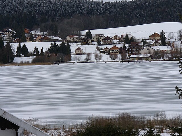

Saint-Point-Lac
- commune in Doubs, France
Hiking in Saint-Point-Lac
Saint-Point-Lac is a beautiful area located in the Jura Mountains of France, known for its stunning natural scenery and diverse hiking opportunities. The region is characterized by its picturesque lake, stunning landscapes, and rich biodiversity, making it a popular destination for hikers and nature enthusiasts....
- Country:
- Postal Code: 25160
- Coordinates: 46° 48' 48" N, 6° 18' 8" E
- GPS tracks (wikiloc): [Link]
- Area: 4.52 sq km
- Population: 280


Oye-et-Pallet
- commune in Doubs, France
Hiking in Oye-et-Pallet
Oye-et-Pallet is a small commune in the Hauts-de-France region of France, located in the Nord department. While it may not be a widely recognized hiking destination, the surrounding areas offer opportunities for outdoor activities and exploring the natural beauty of the region....
- Country:
- Postal Code: 25160
- Coordinates: 46° 51' 12" N, 6° 20' 3" E
- GPS tracks (wikiloc): [Link]
- Area: 10.45 sq km
- Population: 726

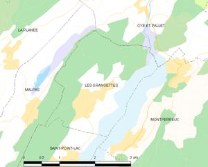
Les Grangettes
- commune in Doubs, France
Hiking in Les Grangettes
Les Grangettes is a beautiful hiking destination located in the French Alps, close to the town of Échirolles and the larger city of Grenoble. The area is known for its stunning natural scenery, characterized by lush meadows, alpine forests, and breathtaking mountain views....
- Country:
- Postal Code: 25160
- Coordinates: 46° 49' 40" N, 6° 18' 40" E
- GPS tracks (wikiloc): [Link]
- Area: 5.38 sq km
- Population: 276

Labergement-Sainte-Marie
- commune in Doubs, France
Hiking in Labergement-Sainte-Marie
Labergement-Sainte-Marie is a charming village located in the Doubs department of the Bourgogne-Franche-Comté region in eastern France. Nestled in the heart of the Jura Mountains, it offers beautiful landscapes, rich flora and fauna, and a variety of hiking opportunities suitable for different skill levels....
- Country:
- Postal Code: 25160
- Coordinates: 46° 46' 29" N, 6° 16' 50" E
- GPS tracks (wikiloc): [Link]
- Area: 22.12 sq km
- Population: 1160