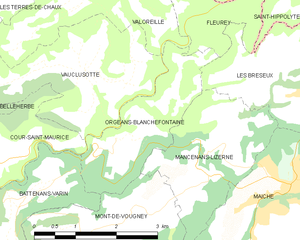
Mancenans-Lizerne (Mancenans-Lizerne)

- commune in Doubs, France
 Hiking in Mancenans-Lizerne
Mancenans-Lizerne is a charming commune located in the Doubs department of the Bourgogne-Franche-Comté region in eastern France. The area is known for its beautiful natural surroundings, making it a great destination for hiking enthusiasts.
Hiking Opportunities
-
Scenic Trails: The region features a variety of hiking trails that offer stunning views of the Jura Mountains and the surrounding landscape. Trails range from easy walks suitable for families to more challenging routes for experienced hikers.
-
Natural Beauty: As you hike in the area, you'll encounter diverse flora and fauna. The lush greenery, forested areas, and open fields provide a perfect backdrop for outdoor activities.
-
Cultural Exploration: While hiking, you can also explore the local culture, including traditional architecture and historical sites. This adds a unique dimension to your hiking experience.
-
Proximity to Other Trails: Mancenans-Lizerne is near larger hiking networks that extend into the Jura region, offering options for longer hikes or multi-day treks if you're looking for an adventure.
Tips for Hiking in Mancenans-Lizerne
- Prepare Properly: Make sure to wear appropriate hiking footwear and clothing. The weather can change quickly in the mountains, so layers are advisable.
- Stay Hydrated: Carry enough water, especially during warmer months.
- Follow Local Guidelines: Always respect nature and follow the established trails to minimize your impact on the environment.
- Check Local Resources: Before you head out, check local visitor centers for maps and recommendations on current trail conditions.
Best Time to Visit
The ideal time for hiking in Mancenans-Lizerne is in the spring and fall when temperatures are mild and the scenery is particularly beautiful. Summer can be hot, and winter may bring snow, affecting trail accessibility.
Overall, hiking in Mancenans-Lizerne can offer a perfect mix of adventure, natural beauty, and cultural experience for those looking to explore the stunning landscapes of eastern France.
- Country:

- Postal Code: 25120
- Coordinates: 47° 15' 40" N, 6° 46' 41" E


- GPS tracks (wikiloc): [Link]
- Area: 6.09 sq km
- Population: 190
- Wikipedia en: wiki(en)
- Wikipedia: wiki(fr)
- Wikidata storage: Wikidata: Q664435
- Wikipedia Commons Category: [Link]
- Freebase ID: [/m/03mgbwv]
- Freebase ID: [/m/03mgbwv]
- GeoNames ID: Alt: [6429865]
- GeoNames ID: Alt: [6429865]
- SIREN number: [212503668]
- SIREN number: [212503668]
- BnF ID: [15252592k]
- BnF ID: [15252592k]
- INSEE municipality code: 25366
- INSEE municipality code: 25366
Shares border with regions:

Orgeans-Blanchefontaine
- commune in Doubs, France
Hiking in Orgeans-Blanchefontaine
Orgeans-Blanchefontaine, located in the Vosges department in northeastern France, is an excellent destination for hiking enthusiasts. The region is known for its beautiful natural landscapes, dense forests, and numerous trails that cater to various skill levels. Here’s what you should know about hiking in this picturesque area:...
- Country:
- Postal Code: 25120
- Coordinates: 47° 15' 48" N, 6° 44' 37" E
- GPS tracks (wikiloc): [Link]
- AboveSeaLevel: 450 м m
- Area: 4.83 sq km
- Population: 49


Les Bréseux
- commune in Doubs, France
Hiking in Les Bréseux
Les Bréseux, a picturesque area located in the Jura Mountains of France near the Swiss border, offers a variety of hiking trails that cater to different skill levels and preferences. Here are some highlights about hiking in Les Bréseux:...
- Country:
- Postal Code: 25120
- Coordinates: 47° 16' 21" N, 6° 48' 37" E
- GPS tracks (wikiloc): [Link]
- Area: 7.37 sq km
- Population: 489
Mont-de-Vougney
- commune in Doubs, France
Hiking in Mont-de-Vougney
Mont-de-Vougney is a lesser-known gem for hikers, located in the Vosges region of France near the border with Switzerland. This area is characterized by its rolling hills, dense forests, and beautiful landscapes, making it a great destination for outdoor enthusiasts....
- Country:
- Postal Code: 25120
- Coordinates: 47° 14' 45" N, 6° 43' 53" E
- GPS tracks (wikiloc): [Link]
- Area: 7.03 sq km
- Population: 176