Manocalzati (Manocalzati)
- Italian comune
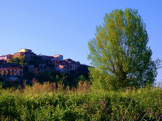
 Hiking in Manocalzati
Manocalzati is a charming town in the Campania region of Italy, located near the vibrant city of Avellino. While Manocalzati itself is not a major hiking destination, it offers access to several scenic trails and the surrounding areas that are ideal for hikers looking to explore the beautiful landscapes of the Irpinia region.
Hiking Overview:
-
Natural Environment:
- The area around Manocalzati is characterized by rolling hills, lush forests, and vineyards. This picturesque scenery provides a serene backdrop for hiking and outdoor activities.
- The nearby Partenio Regional Park is a notable destination for hiking enthusiasts, featuring a variety of trails suitable for different skill levels.
-
Popular Trails:
- Partenio Regional Park: Explore trails that lead through dense woodlands, past charming villages, and to beautiful viewpoints. The trails can range from easy walks to more challenging hikes with varying elevation changes.
- Monte Terminio: This mountain, part of the same range, offers more difficult trails with stunning panoramic views of the surrounding landscape.
-
Cultural Aspects:
- Hiking in the region provides an opportunity to immerse yourself in the local culture. You may encounter traditional villages, historic churches, and local cuisine along the way.
- Be sure to try local specialties, such as wine from the surrounding vineyards or traditional dishes served at town trattorias.
-
Best Time to Hike:
- Spring and fall are ideal times for hiking in Campania, as the weather is mild and the landscapes are vibrant with colors. Summer can be hot, while winter may bring snow to higher elevations.
-
Preparation:
- As with any hike, ensure you have the right gear: sturdy hiking boots, plenty of water, sun protection, and a map or GPS device, especially if you are venturing into less-traveled areas.
- It’s also wise to check local conditions or hire a guide if you’re unfamiliar with the terrain.
Conclusion:
While Manocalzati may not be the most well-known hiking destination, its proximity to beautiful natural areas and cultural experiences makes it a hidden gem for those looking to enjoy the outdoors in a picturesque Italian setting.
- Country:

- Postal Code: 83030
- Local Dialing Code: 0825
- Licence Plate Code: AV
- Coordinates: 40° 56' 33" N, 14° 51' 2" E


- GPS tracks (wikiloc): [Link]
- AboveSeaLevel: 450 м m
- Area: 8.75 sq km
- Population: 3198
- Web site: http://www.comune.manocalzati.av.it/
- Wikipedia en: wiki(en)
- Wikipedia: wiki(it)
- Wikidata storage: Wikidata: Q55050
- Wikipedia Commons Category: [Link]
- Freebase ID: [/m/0fg0b6]
- GeoNames ID: Alt: [6537365]
- VIAF ID: Alt: [308750712]
- OSM relation ID: [40921]
- UN/LOCODE: [ITMZ9]
- ISTAT ID: 064046
- Italian cadastre code: E891
Shares border with regions:


Avellino
- Italian comune
Hiking in Avellino
Avellino, located in the Campania region of southern Italy, offers a variety of hiking opportunities that showcase its stunning natural landscapes, rolling hills, and mountainous terrain. The region is well known for its beautiful parks and trails that cater to different skill levels. Here are some highlights of hiking in Avellino:...
- Country:
- Postal Code: 83100
- Local Dialing Code: 0825
- Licence Plate Code: AV
- Coordinates: 40° 54' 55" N, 14° 47' 23" E
- GPS tracks (wikiloc): [Link]
- AboveSeaLevel: 348 м m
- Area: 30.55 sq km
- Population: 60000
- Web site: [Link]

Atripalda
- Italian comune
Hiking in Atripalda
Atripalda, located in the Campania region of Italy, offers a picturesque setting for hiking enthusiasts. Nestled in the hills near Avellino, Atripalda provides access to various trails that showcase the natural beauty of the Irpinia region, including lush landscapes and scenic views of the surrounding mountains and valleys....
- Country:
- Postal Code: 83042
- Local Dialing Code: 0825
- Licence Plate Code: AV
- Coordinates: 40° 55' 0" N, 14° 49' 32" E
- GPS tracks (wikiloc): [Link]
- AboveSeaLevel: 294 м m
- Area: 8.59 sq km
- Population: 10968
- Web site: [Link]
Candida
- Italian comune
Hiking in Candida
Hiking in Candida, a small town in the Campania region of Italy, offers a delightful experience for nature lovers and outdoor enthusiasts. The area is part of the larger Irpinia region, known for its beautiful landscapes, rolling hills, and rich agricultural heritage. Here are some key points to consider about hiking in and around Candida:...
- Country:
- Postal Code: 83040
- Local Dialing Code: 0825
- Licence Plate Code: AV
- Coordinates: 40° 56' 36" N, 14° 52' 30" E
- GPS tracks (wikiloc): [Link]
- AboveSeaLevel: 579 м m
- Area: 5.35 sq km
- Population: 1121
- Web site: [Link]

Montefredane
- Italian comune
Hiking in Montefredane
Montefredane, located in the Campania region of Italy, is surrounded by beautiful landscapes and offers various hiking opportunities. Here are some key points about hiking in this area:...
- Country:
- Postal Code: 83030
- Local Dialing Code: 0825
- Licence Plate Code: AV
- Coordinates: 40° 58' 0" N, 14° 49' 0" E
- GPS tracks (wikiloc): [Link]
- AboveSeaLevel: 593 м m
- Area: 9.45 sq km
- Population: 2239
- Web site: [Link]

Pratola Serra
- Italian comune
Hiking in Pratola Serra
Pratola Serra is a charming town located in the province of Avellino in the Campania region of Italy. It is nestled in a mountainous area, making it an excellent location for hiking enthusiasts. Here are some details and tips for hiking in and around Pratola Serra:...
- Country:
- Postal Code: 83039
- Local Dialing Code: 0825
- Licence Plate Code: AV
- Coordinates: 40° 59' 0" N, 14° 51' 0" E
- GPS tracks (wikiloc): [Link]
- AboveSeaLevel: 280 м m
- Area: 8.84 sq km
- Population: 3866
- Web site: [Link]
San Potito Ultra
- Italian comune
Hiking in San Potito Ultra
San Potito Ultra is a charming destination for hiking, located in the Campania region of Italy, particularly in the province of Salerno. This area offers a combination of scenic landscapes, rich biodiversity, and cultural heritage, making it an appealing spot for outdoor enthusiasts....
- Country:
- Postal Code: 83050
- Local Dialing Code: 0825
- Licence Plate Code: AV
- Coordinates: 40° 56' 0" N, 14° 52' 0" E
- GPS tracks (wikiloc): [Link]
- AboveSeaLevel: 500 м m
- Area: 4.54 sq km
- Population: 1535
- Web site: [Link]