
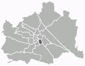
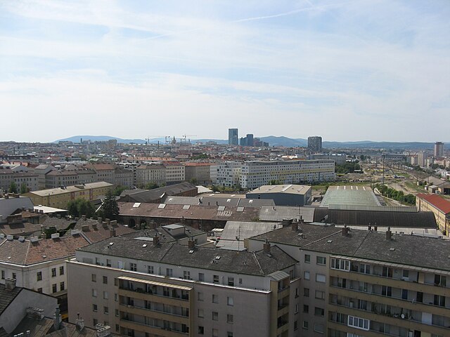
Margareten (Margareten)

- 5. district of Vienna
 Hiking in Margareten
Margareten is a district in Vienna, Austria, known more for its urban environment than for hiking opportunities. However, if you're looking to enjoy nature and get some hiking in, you can venture into nearby areas that offer beautiful trails.
Hiking Options Near Margareten:
-
Wiener Wald (Vienna Woods): This vast forested area is just a short trip from Margareten and offers numerous hiking trails suitable for all levels. The Wiener Wald is ideal for enjoying nature, with picturesque views and diverse flora and fauna.
-
Kahlenberg: A popular hill in the vicinity, Kahlenberg offers excellent trails with stunning views of Vienna and the surrounding vineyards. You can start your hike in the city and make your way up to the observation point.
-
Lainzer Tiergarten: This nature reserve is not far from Margareten and provides a range of trails amid lush landscapes. It's also home to the Hermesvilla, a historic building, and offers a chance to see wildlife.
-
Rax and Schneeberg: If you’re up for a longer journey by train or car, these mountain areas are a bit further out and offer more demanding hikes with spectacular alpine scenery.
Tips for Hiking from Margareten:
- Transportation: Use Vienna's efficient public transport to reach your hiking destination. Most trails are accessible via the U-Bahn or trams.
- Local Maps: Consider getting a hiking map of the area or using a hiking app to navigate trails.
- Weather Considerations: Check the weather before heading out, as conditions can change quickly, especially in the hills and woods.
- Hydration and Snacks: Bring plenty of water and snacks to keep your energy up while hiking.
While Margareten itself may not offer direct hiking trails, the surrounding areas definitely provide great opportunities to explore the beautiful Austrian landscape. Enjoy your hiking adventures!
- Country:

- Postal Code: 1050
- Licence Plate Code: W
- Coordinates: 48° 11' 14" N, 16° 21' 11" E


- GPS tracks (wikiloc): [Link]
- AboveSeaLevel: 185 м m
- Area: 2.03 sq km
- Population: 55356
- Web site: http://www.wien.gv.at/bezirke/margareten/
- Wikipedia en: wiki(en)
- Wikipedia: wiki(de)
- Wikidata storage: Wikidata: Q252731
- Wikipedia Commons Gallery: [Link]
- Wikipedia Commons Category: [Link]
- Wikipedia Commons Maps Category: [Link]
- Freebase ID: [/m/06r29m]
- GeoNames ID: Alt: [2771956]
- VIAF ID: Alt: [131744831]
- OSM relation ID: [1991440]
- GND ID: Alt: [4079293-6]
- archINFORM location ID: [3685]
- Austrian municipality key: [90501]
Shares border with regions:

Wieden
- 4. district of Vienna
Hiking in Wieden
Wieden is a charming district in Vienna, Austria, known for its historic architecture, vibrant atmosphere, and cultural significance. While it's not primarily known as a hiking destination, you can find some lovely walking and exploration opportunities in and around Wieden. Here are some suggestions for enjoying the outdoors in and around this area:...
- Country:
- Postal Code: 1040
- Licence Plate Code: W
- Coordinates: 48° 11' 22" N, 16° 21' 42" E
- GPS tracks (wikiloc): [Link]
- AboveSeaLevel: 184 м m
- Area: 1.8 sq km
- Web site: [Link]
Mariahilf
- 6. district of Vienna
Hiking in Mariahilf
Mariahilf, a vibrant district in Vienna, Austria, is better known for its urban landscape, cultural offerings, and shopping rather than hiking. However, if you’re looking for hiking opportunities near Mariahilf, you can explore nearby natural areas and trails within the larger Vienna region....
- Country:
- Postal Code: 1060
- Licence Plate Code: W
- Coordinates: 48° 11' 43" N, 16° 20' 59" E
- GPS tracks (wikiloc): [Link]
- AboveSeaLevel: 198 м m
- Area: 1.48 sq km
- Web site: [Link]

Favoriten
- 10. district of Vienna
Hiking in Favoriten
Favoriten is the 10th district of Vienna, Austria, and while it is primarily known as an urban area, it offers some opportunities for hiking and outdoor activities. Here are a few points to consider if you're looking to hike in or near Favoriten:...
- Country:
- Postal Code: 1100
- Licence Plate Code: W
- Coordinates: 48° 9' 28" N, 16° 21' 33" E
- GPS tracks (wikiloc): [Link]
- AboveSeaLevel: 230 м m
- Area: 31.8 sq km
- Web site: [Link]


Meidling
- 12. district of Vienna
Hiking in Meidling
Meidling is a district in Vienna, Austria, known more for its urban environment than for hiking. However, it provides access to some nearby nature areas and parks that can offer short hiking opportunities or outdoor activities....
- Country:
- Postal Code: 1120
- Licence Plate Code: W
- Coordinates: 48° 9' 42" N, 16° 19' 18" E
- GPS tracks (wikiloc): [Link]
- AboveSeaLevel: 218 м m
- Area: 8.16 sq km
- Web site: [Link]