
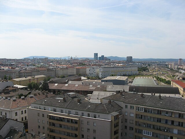
Vienna (Wien)
.svg)

- capital and one of nine States of Austria
 Hiking in Vienna
As a hiking instructor, I'd be happy to tell you about hiking opportunities in Vienna! While Vienna is primarily known for its rich history, art, and culture, it also offers beautiful natural spaces perfect for hiking. Here are some of the top spots:
-
Wienerwald (Vienna Woods): With more than 600 square kilometers of forest, the Wienerwald offers a wide range of hiking trails that cater to different levels of experience. You can enjoy peaceful strolls or challenging hikes with stunning views of Vienna and its surroundings.
-
Donauinsel (Danube Island): A 21.5 km long recreational area located on an island in the Danube river, Donauinsel offers numerous walking and biking paths, as well as beautiful beaches during the summer months. It's a great place for a leisurely hike or jog.
-
Kahlenberg: Located in the northern part of Vienna Woods, Kahlenberg is one of Vienna's five hills and offers fantastic views over the city. The hiking trail to the top can be challenging but rewarding, with a beautiful viewpoint at the summit.
-
Riegler Hütte Trail: This popular trail leads from the Prater Park to the Riegler Hut in Wienerwald. It's about 10 km long and offers a mix of forest trails, meadows, and quaint villages along the way.
-
Erlöser-Kapelle Trail: This trail takes you through the rolling hills of Vienna Woods to the Erlöser-Kapelle chapel, which dates back to the 18th century. The trail is relatively easy and offers a peaceful hiking experience away from the city bustle.
When hiking in Vienna, it's essential to wear appropriate gear, including sturdy shoes, weather-appropriate clothing, and sun protection during summer months. Always stay on marked trails and follow local regulations for your safety and the preservation of the natural environment. Happy hiking!
- Country:

- Postal Code: 1901; 1810; 1600–1601; 1502–1503; 1500; 1423; 1421; 1300–1301; 1251–1255; 1402; 1400; 1000–1239
- Local Dialing Code: 01
- Licence Plate Code: W
- Coordinates: 48° 12' 30" N, 16° 22' 23" E


- GPS tracks (wikiloc): [Link]
- AboveSeaLevel: 542 м m
- Area: 414.87 sq km
- Population: 1840573
- Web site: https://www.wien.gv.at/
- Wikipedia en: wiki(en)
- Wikipedia: wiki(de)
- Wikidata storage: Wikidata: Q1741
- Wikipedia Commons Gallery: [Link]
- Wikipedia Commons Category: [Link]
- Wikipedia Commons Maps Category: [Link]
- Freebase ID: [/m/0fhp9]
- GeoNames ID: Alt: [2761369]
- BnF ID: [118808983]
- VIAF ID: Alt: [155870729]
- OSM relation ID: [109166]
- GND ID: Alt: [4066009-6]
- archINFORM location ID: [1385]
- Library of Congress authority ID: Alt: [n79018895]
- MusicBrainz area ID: [afff1a94-a98b-4322-8874-3148139ab6da]
- Quora topic ID: [Vienna-Austria-3]
- TGN ID: [7003321]
- SUDOC authorities ID: [026590697]
- Encyclopædia Britannica Online ID: [place/Vienna]
- Encyclopædia Universalis ID: [vienne-autriche]
- EMLO location ID: [c0b1e887-b6c0-4fc8-97d8-63d238d0603f]
- Facebook Places ID: [111165112241092]
- Great Russian Encyclopedia Online ID: [1906355]
- Austrian municipality key: [90001]
- ISNI: Alt: [0000 0001 2186 5140]
- NKCR AUT ID: [ge131380]
- National Library of Israel ID: [000137900]
- NUTS code: [AT130]
- YSO ID: [106956]
- Nomisma ID: [vienna]
- Klexikon article ID: [Wien]
- Brockhaus Enzyklopädie online ID: [wien-20]
- subreddit: [wien]
- NDL Auth ID: [00628254]
- UK Parliament thesaurus ID: [13605]
- STW Thesaurus for Economics ID: [16955-1]
- Canadiana Authorities ID: [0053F1558]
- National Gallery of Victoria artist ID: [17119]
- Theatricalia theatre ID: [29t]
- JewishGen Locality ID: [1995499]
- US National Archives Identifier: 10044903
- ISO 3166-2 code: AT-9
- FIPS 10-4 (countries and regions): AU09
Includes regions:
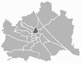
Margareten
- 5. district of Vienna
Hiking in Margareten
Margareten is a district in Vienna, Austria, known more for its urban environment than for hiking opportunities. However, if you're looking to enjoy nature and get some hiking in, you can venture into nearby areas that offer beautiful trails....
- Country:
- Postal Code: 1050
- Licence Plate Code: W
- Coordinates: 48° 11' 14" N, 16° 21' 11" E
- GPS tracks (wikiloc): [Link]
- AboveSeaLevel: 185 м m
- Area: 2.03 sq km
- Population: 55356
- Web site: [Link]
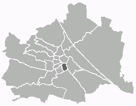
Josefstadt
- 8. district of Vienna
Hiking in Josefstadt
Josefstadt is a district in Vienna, Austria, known more for its urban characteristics rather than hiking trails. However, its proximity to the Vienna Woods (Wienerwald) offers great opportunities for hiking enthusiasts. While the district itself may not have dedicated hiking trails, you can easily access various trails in the nearby areas....
- Country:
- Postal Code: 1080
- Licence Plate Code: W
- Coordinates: 48° 12' 39" N, 16° 20' 53" E
- GPS tracks (wikiloc): [Link]
- AboveSeaLevel: 209 м m
- Area: 1.08 sq km
- Web site: [Link]

Alsergrund
- 9. district of Vienna
Hiking in Alsergrund
Alsergrund is one of the 23 districts of Vienna, Austria, and while it's not primarily known for hiking in the traditional sense of wilderness trails, it does offer some enjoyable walking opportunities, particularly for urban hiking or strolling through green spaces....
- Country:
- Postal Code: 1090
- Licence Plate Code: W
- Coordinates: 48° 13' 31" N, 16° 21' 25" E
- GPS tracks (wikiloc): [Link]
- AboveSeaLevel: 179 м m
- Area: 2.99 sq km
- Web site: [Link]


Donaustadt
- 22. district of Vienna, Austria
Hiking in Donaustadt
Donaustadt is a district in Vienna, Austria, located along the banks of the Danube River. It offers a unique combination of urban and natural landscapes, making it an attractive destination for hikers. Here are some highlights and tips for hiking in Donaustadt:...
- Country:
- Postal Code: 1220
- Licence Plate Code: W
- Coordinates: 48° 13' 5" N, 16° 28' 59" E
- GPS tracks (wikiloc): [Link]
- AboveSeaLevel: 152 м m
- Area: 102.29 sq km
- Web site: [Link]


Leopoldstadt
- 2nd municipal District of Vienna, Austria
Hiking in Leopoldstadt
Leopoldstadt is the second district of Vienna, Austria, known for its vibrant culture, parks, and proximity to the Danube River. While it may not offer traditional hiking trails found in mountainous regions, there are still great opportunities for outdoor activities and leisurely walks....
- Country:
- Postal Code: 1020
- Licence Plate Code: W
- Coordinates: 48° 12' 37" N, 16° 24' 44" E
- GPS tracks (wikiloc): [Link]
- AboveSeaLevel: 158 м m
- Area: 19.27 sq km
- Web site: [Link]
Hernals
- 17. district of Vienna
Hiking in Hernals
Hernals is a district in Vienna, Austria, known for its charming neighborhoods and proximity to nature. While Hernals itself is primarily urban, the nearby areas, especially the Vienna Woods (Wienerwald), offer excellent hiking opportunities....
- Country:
- Postal Code: 1170
- Licence Plate Code: W
- Coordinates: 48° 13' 57" N, 16° 16' 46" E
- GPS tracks (wikiloc): [Link]
- AboveSeaLevel: 224 м m
- Area: 11.35 sq km
- Web site: [Link]

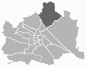
Floridsdorf
- 21. district of Vienna
Hiking in Floridsdorf
Floridsdorf is one of the 23 districts of Vienna, Austria, and while it is primarily an urban area, there are some lovely opportunities for outdoor activities and hiking in and around the district. Here are some highlights for hiking enthusiasts:...
- Country:
- Postal Code: 1210
- Licence Plate Code: W
- Coordinates: 48° 17' 0" N, 16° 24' 44" E
- GPS tracks (wikiloc): [Link]
- AboveSeaLevel: 159 м m
- Area: 44.52 sq km
- Web site: [Link]
Brigittenau
- 20. district of Vienna
Hiking in Brigittenau
Brigittenau is a 20th district of Vienna, Austria, situated on the northern banks of the Danube Canal. While it is an urban area and not traditionally associated with hiking, it still offers some opportunities for walking and enjoying the outdoors. Here are some aspects to consider if you’re interested in hiking or walking in and around Brigittenau:...
- Country:
- Postal Code: 1200
- Licence Plate Code: W
- Coordinates: 48° 14' 12" N, 16° 22' 10" E
- GPS tracks (wikiloc): [Link]
- AboveSeaLevel: 165 м m
- Area: 5.67 sq km
- Web site: [Link]
Ottakring
- 16. district of Vienna
Hiking in Ottakring
Ottakring is a vibrant district in Vienna, Austria, known for its mix of urban culture and access to nature. While Ottakring is primarily an urban area, it serves as a gateway to various hiking opportunities in the surrounding regions. Here are some highlights and tips for hiking near Ottakring:...
- Country:
- Postal Code: 1160
- Licence Plate Code: W
- Coordinates: 48° 12' 45" N, 16° 18' 38" E
- GPS tracks (wikiloc): [Link]
- AboveSeaLevel: 247 м m
- Area: 8.65 sq km
- Web site: [Link]

Innere Stadt
- first district of Vienna
Hiking in Innere Stadt
Innere Stadt, the historic city center of Vienna, Austria, is not typically known for hiking in the traditional sense; however, it offers plenty of opportunities for urban exploration and walking that can be quite enjoyable and fulfilling. The area is rich in history, culture, and stunning architecture, making it an ideal destination for long strolls and leisurely walks....
- Country:
- Postal Code: 1010
- Licence Plate Code: W
- Coordinates: 48° 12' 35" N, 16° 22' 12" E
- GPS tracks (wikiloc): [Link]
- AboveSeaLevel: 192 м m
- Area: 3.01 sq km
- Web site: [Link]


Döbling
- 19. district of Vienna
Hiking in Döbling
Döbling is a charming district in Vienna, Austria, known for its scenic landscapes, vineyards, and proximity to the Vienna Woods (Wienerwald). Here are some highlights and tips for hiking in Döbling:...
- Country:
- Postal Code: 1190
- Licence Plate Code: W
- Coordinates: 48° 15' 59" N, 16° 19' 22" E
- GPS tracks (wikiloc): [Link]
- AboveSeaLevel: 247 м m
- Area: 24.9 sq km
- Web site: [Link]

Wieden
- 4. district of Vienna
Hiking in Wieden
Wieden is a charming district in Vienna, Austria, known for its historic architecture, vibrant atmosphere, and cultural significance. While it's not primarily known as a hiking destination, you can find some lovely walking and exploration opportunities in and around Wieden. Here are some suggestions for enjoying the outdoors in and around this area:...
- Country:
- Postal Code: 1040
- Licence Plate Code: W
- Coordinates: 48° 11' 22" N, 16° 21' 42" E
- GPS tracks (wikiloc): [Link]
- AboveSeaLevel: 184 м m
- Area: 1.8 sq km
- Web site: [Link]
Liesing
- 23. district of Vienna
Hiking in Liesing
Liesing is a district in Vienna, Austria, that is often known for its lush landscapes and access to nature. While Liesing itself is more urban, it’s also adjacent to several natural areas that offer great hiking opportunities. Here are some insights into hiking in and around Liesing:...
- Country:
- Postal Code: 1230
- Licence Plate Code: W
- Coordinates: 48° 8' 16" N, 16° 17' 4" E
- GPS tracks (wikiloc): [Link]
- AboveSeaLevel: 212 м m
- Area: 32.02 sq km
- Web site: [Link]


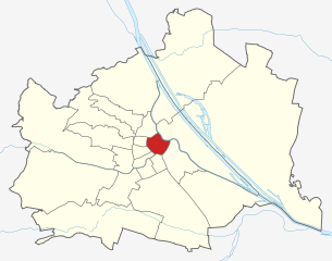
Simmering
- 11. district of Vienna
Hiking in Simmering
Simmering is a district in the southeastern part of Vienna, and while it is primarily an urban area, there are some opportunities for enjoyable walks and light hiking in the vicinity. Here are some key points to consider for anyone wanting to explore hiking-like experiences in and around Simmering:...
- Country:
- Postal Code: 1110
- Licence Plate Code: W
- Coordinates: 48° 10' 12" N, 16° 27' 0" E
- GPS tracks (wikiloc): [Link]
- AboveSeaLevel: 156 м m
- Area: 23.27 sq km
- Population: 97333
- Web site: [Link]
Landstraße
- 3rd municipal District of Vienna, Austria
Hiking in Landstraße
Landstraße, located in Vienna, Austria, is not traditionally known for hiking, as it is primarily an urban district. However, there are plenty of walking and exploration opportunities in and around this area, especially for those interested in urban hikes or scenic walks....
- Country:
- Postal Code: 1030
- Licence Plate Code: W
- Coordinates: 48° 11' 47" N, 16° 23' 45" E
- GPS tracks (wikiloc): [Link]
- AboveSeaLevel: 178 м m
- Area: 7.39 sq km
- Web site: [Link]
Hietzing
- district of Vienna
Hiking in Hietzing
Hietzing is a district located in the western part of Vienna, Austria, and it’s known for its beautiful natural landscapes, historical sites, and access to natural parks, making it a great place for hiking enthusiasts....
- Country:
- Postal Code: 1130
- Licence Plate Code: W
- Coordinates: 48° 10' 53" N, 16° 15' 29" E
- GPS tracks (wikiloc): [Link]
- AboveSeaLevel: 244 м m
- Area: 37.7 sq km
- Web site: [Link]
Rudolfsheim-Fünfhaus
- 15. district of Vienna
Hiking in Rudolfsheim-Fünfhaus
Rudolfsheim-Fünfhaus is a district in Vienna, Austria, primarily known for its urban atmosphere rather than extensive hiking trails. However, outdoor enthusiasts can still enjoy various activities in and around the district. Here are some suggestions:...
- Country:
- Postal Code: 1150
- Licence Plate Code: W
- Coordinates: 48° 12' 3" N, 16° 19' 12" E
- GPS tracks (wikiloc): [Link]
- AboveSeaLevel: 221 м m
- Area: 3.86 sq km
- Web site: [Link]
Mariahilf
- 6. district of Vienna
Hiking in Mariahilf
Mariahilf, a vibrant district in Vienna, Austria, is better known for its urban landscape, cultural offerings, and shopping rather than hiking. However, if you’re looking for hiking opportunities near Mariahilf, you can explore nearby natural areas and trails within the larger Vienna region....
- Country:
- Postal Code: 1060
- Licence Plate Code: W
- Coordinates: 48° 11' 43" N, 16° 20' 59" E
- GPS tracks (wikiloc): [Link]
- AboveSeaLevel: 198 м m
- Area: 1.48 sq km
- Web site: [Link]
Neubau
- 7. district of Vienna
Hiking in Neubau
Neubau, a vibrant district in Vienna, Austria, is not traditionally known for its hiking trails like the surrounding nature areas. However, it offers access to some scenic routes and nearby parks that can provide a pleasant experience for those looking to enjoy a nature walk or light hiking within the urban environment....
- Country:
- Postal Code: 1070
- Licence Plate Code: W
- Coordinates: 48° 12' 9" N, 16° 20' 53" E
- GPS tracks (wikiloc): [Link]
- AboveSeaLevel: 214 м m
- Area: 1.61 sq km
- Web site: [Link]
Penzing
- 14. district of Vienna
Hiking in Penzing
Penzing is a district in the western part of Vienna, Austria, and while it is more urbanized compared to remote hiking destinations, there are still opportunities for outdoor activities and hiking nearby. Here are some options and tips for hiking around Penzing:...
- Country:
- Postal Code: 1140
- Licence Plate Code: W
- Coordinates: 48° 11' 56" N, 16° 18' 40" E
- GPS tracks (wikiloc): [Link]
- AboveSeaLevel: 238 м m
- Area: 33.82 sq km
- Web site: [Link]
Währing
- 18th district of Vienna
Hiking in Währing
Währing is a district in Vienna, Austria, known for its beautiful parks and hills, making it a delightful destination for hiking enthusiasts. Here are some highlights and tips for hiking in Währing:...
- Country:
- Postal Code: 1180
- Licence Plate Code: W
- Coordinates: 48° 13' 59" N, 16° 18' 53" E
- GPS tracks (wikiloc): [Link]
- AboveSeaLevel: 247 м m
- Area: 6.28 sq km
- Web site: [Link]

Favoriten
- 10. district of Vienna
Hiking in Favoriten
Favoriten is the 10th district of Vienna, Austria, and while it is primarily known as an urban area, it offers some opportunities for hiking and outdoor activities. Here are a few points to consider if you're looking to hike in or near Favoriten:...
- Country:
- Postal Code: 1100
- Licence Plate Code: W
- Coordinates: 48° 9' 28" N, 16° 21' 33" E
- GPS tracks (wikiloc): [Link]
- AboveSeaLevel: 230 м m
- Area: 31.8 sq km
- Web site: [Link]


Meidling
- 12. district of Vienna
Hiking in Meidling
Meidling is a district in Vienna, Austria, known more for its urban environment than for hiking. However, it provides access to some nearby nature areas and parks that can offer short hiking opportunities or outdoor activities....
- Country:
- Postal Code: 1120
- Licence Plate Code: W
- Coordinates: 48° 9' 42" N, 16° 19' 18" E
- GPS tracks (wikiloc): [Link]
- AboveSeaLevel: 218 м m
- Area: 8.16 sq km
- Web site: [Link]
Shares border with regions:
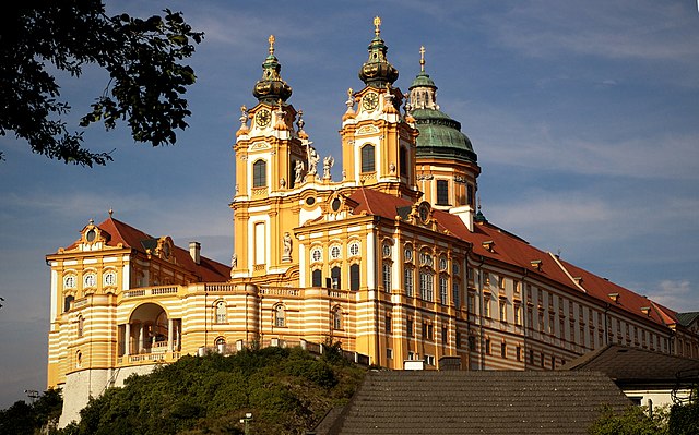

Lower Austria
- federated state of Austria
Hiking in Lower Austria
Lower Austria, known as Niederösterreich in German, is a fantastic destination for hiking enthusiasts. The region is characterized by its diverse landscapes, including rolling hills, vineyards, forests, and the scenic Danube River. Here are some highlights and popular hiking areas in Lower Austria:...
- Country:
- Capital: St. Pölten
- Coordinates: 48° 20' 0" N, 15° 45' 0" E
- GPS tracks (wikiloc): [Link]
- AboveSeaLevel: 279 м m
- Area: 19186.0 sq km
- Population: 1653419
- Web site: [Link]