Marsas (Marsas)

- commune in Hautes-Pyrénées, France
- Country:

- Postal Code: 65200
- Coordinates: 43° 3' 7" N, 0° 13' 34" E


- GPS tracks (wikiloc): [Link]
- Area: 2.77 sq km
- Population: 71
- Wikipedia en: wiki(en)
- Wikipedia: wiki(fr)
- Wikidata storage: Wikidata: Q1163161
- Wikipedia Commons Category: [Link]
- Freebase ID: [/m/03qcsvb]
- Freebase ID: [/m/03qcsvb]
- GeoNames ID: Alt: [6440824]
- GeoNames ID: Alt: [6440824]
- SIREN number: [216503003]
- SIREN number: [216503003]
- BnF ID: [15270680s]
- BnF ID: [15270680s]
- INSEE municipality code: 65300
- INSEE municipality code: 65300
Shares border with regions:


Banios
- commune in Hautes-Pyrénées, France
- Country:
- Postal Code: 65200
- Coordinates: 43° 2' 40" N, 0° 14' 4" E
- GPS tracks (wikiloc): [Link]
- Area: 5.26 sq km
- Population: 51

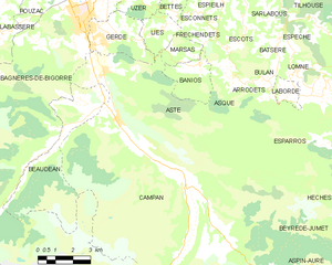
Asté
- commune in Hautes-Pyrénées, France
- Country:
- Postal Code: 65200
- Coordinates: 43° 2' 27" N, 0° 10' 5" E
- GPS tracks (wikiloc): [Link]
- Area: 26.67 sq km
- Population: 548

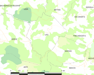
Lies
- commune in Hautes-Pyrénées, France
- Country:
- Postal Code: 65200
- Coordinates: 43° 3' 45" N, 0° 12' 33" E
- GPS tracks (wikiloc): [Link]
- Area: 3.66 sq km
- Population: 67

Fréchendets
- commune in Hautes-Pyrénées, France
- Country:
- Postal Code: 65130
- Coordinates: 43° 3' 43" N, 0° 14' 23" E
- GPS tracks (wikiloc): [Link]
- Area: 2.02 sq km
- Population: 32