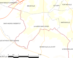
Martainville (Martainville)
- commune in Eure, France
- Country:

- Postal Code: 27210
- Coordinates: 49° 18' 24" N, 0° 24' 23" E


- GPS tracks (wikiloc): [Link]
- Area: 9.09 sq km
- Population: 462
- Wikipedia en: wiki(en)
- Wikipedia: wiki(fr)
- Wikidata storage: Wikidata: Q1073809
- Wikipedia Commons Category: [Link]
- Freebase ID: [/m/02x6brb]
- Freebase ID: [/m/02x6brb]
- GeoNames ID: Alt: [6453897]
- GeoNames ID: Alt: [6453897]
- SIREN number: [212703938]
- SIREN number: [212703938]
- BnF ID: [152536280]
- BnF ID: [152536280]
- INSEE municipality code: 27393
- INSEE municipality code: 27393
Shares border with regions:


Fort-Moville
- commune in Eure, France
- Country:

- Postal Code: 27210
- Coordinates: 49° 20' 0" N, 0° 25' 8" E


- GPS tracks (wikiloc): [Link]
- Area: 9.32 sq km
- Population: 476


La Lande-Saint-Léger
- commune in Eure, France
- Country:

- Postal Code: 27210
- Coordinates: 49° 17' 58" N, 0° 21' 52" E


- GPS tracks (wikiloc): [Link]
- AboveSeaLevel: 152 м m
- Area: 7.96 sq km
- Population: 344


Le Bois-Hellain
- commune in Eure, France
- Country:

- Postal Code: 27260
- Coordinates: 49° 16' 44" N, 0° 23' 22" E


- GPS tracks (wikiloc): [Link]
- Area: 3.2 sq km
- Population: 230


La Chapelle-Bayvel
- commune in Eure, France
- Country:

- Postal Code: 27260
- Coordinates: 49° 16' 19" N, 0° 24' 10" E


- GPS tracks (wikiloc): [Link]
- Area: 4.84 sq km
- Population: 400


Bonneville-la-Louvet
- commune in Calvados, France
- Country:

- Postal Code: 14130
- Coordinates: 49° 16' 29" N, 0° 20' 21" E


- GPS tracks (wikiloc): [Link]
- Area: 20.75 sq km
- Population: 741
