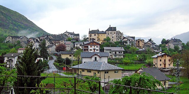
Masera (Masera)
- Italian comune
 Hiking in Masera
Masera is a charming commune located in the province of Verbano-Cusio-Ossola in the Piedmont region of northern Italy. It is nestled in the scenic Val D’Ossola, an area known for its stunning natural landscapes, lush valleys, and impressive mountain ranges, making it a fantastic destination for hiking enthusiasts.
Hiking Trails
-
Val Grande National Park: This park, located nearby, offers numerous hiking trails that vary in difficulty and length. The rugged terrain and pristine nature make it an ideal spot for day hikes or multi-day treks.
-
Sentiero del Santuario di Madonna del Sasso: This trail leads you up to the Sanctuary of Madonna del Sasso and provides breathtaking views of the surrounding lakes and mountains. It’s a moderately challenging hike that rewards you with beautiful scenery.
-
Monte Faié: A hike to the summit of Monte Faié offers panoramic views of the surrounding valleys. The trail is well-marked and suitable for those with moderate hiking experience.
-
Local Trails: There are many well-maintained local trails that meander through forests, along rivers, and past charming alpine villages. These trails vary in length and difficulty, catering to different hiking preferences.
Best Time to Hike
- Spring (April to June): This is one of the best times to hike in Masera, as the weather is generally mild, and the wildflowers bloom, adding color to the landscape.
- Summer (July to August): The summer months can be warmer, but they offer longer days for hiking. Be prepared for heat and ensure proper hydration.
- Fall (September to October): The fall foliage creates stunning views. The temperatures are cooler, making it a comfortable time for hiking.
- Winter (November to March): During the winter, some trails may be covered in snow, offering opportunities for snowshoeing or winter hiking, but be cautious of icy conditions.
Tips for Hiking in Masera
- Check Weather Conditions: Always check the weather forecast before heading out, as conditions can change rapidly in mountainous areas.
- Essential Gear: Wear proper hiking boots, carry a map or GPS device, and have layered clothing to adjust to temperature changes. Don’t forget hydration and snacks!
- Respect Nature: Stay on marked trails, pack out what you bring in, and follow Leave No Trace principles to preserve the natural beauty.
- Local Guides: If you're unfamiliar with the area, consider hiring a local guide who can provide insights into the flora, fauna, and history of the region.
In summary, hiking in Masera offers a wonderful opportunity to explore the natural beauty of northern Italy, with a variety of trails that cater to different skill levels and interests. Enjoy your adventure!
- Country:

- Postal Code: 28855
- Local Dialing Code: 0324
- Licence Plate Code: VB
- Coordinates: 46° 10' 0" N, 8° 18' 0" E


- GPS tracks (wikiloc): [Link]
- AboveSeaLevel: 297 м m
- Area: 20.35 sq km
- Population: 1483
- Web site: http://www.comune.masera.vb.it
- Wikipedia en: wiki(en)
- Wikipedia: wiki(it)
- Wikidata storage: Wikidata: Q23627
- Wikipedia Commons Category: [Link]
- Freebase ID: [/m/0gr8hg]
- GeoNames ID: Alt: [6540968]
- OSM relation ID: [46907]
- UN/LOCODE: [ITV5B]
- ISTAT ID: 103042
- Italian cadastre code: F010
Shares border with regions:

Crevoladossola
- Italian comune
Hiking in Crevoladossola
Crevoladossola is a charming town located in the Piedmont region of northern Italy, nestled at the entrance to the Val Vigezzo, surrounded by stunning Alpine scenery. The area offers a variety of hiking opportunities that cater to different skill levels, from leisurely walks to more challenging treks....
- Country:
- Postal Code: 28865
- Local Dialing Code: 0324
- Licence Plate Code: VB
- Coordinates: 46° 10' 0" N, 8° 18' 0" E
- GPS tracks (wikiloc): [Link]
- AboveSeaLevel: 375 м m
- Area: 39.87 sq km
- Population: 4600
- Web site: [Link]
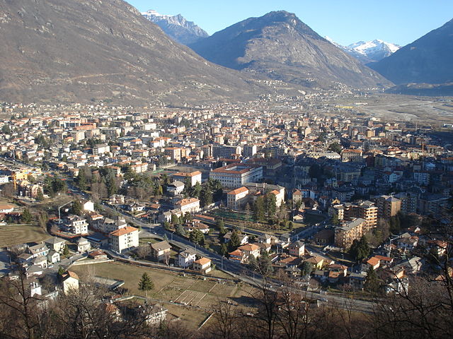
Domodossola
- Italian comune
Hiking in Domodossola
Domodossola, located in the Ossola Valley in northern Italy, is surrounded by stunning natural landscapes, making it a fantastic destination for hiking enthusiasts. Here are some key points about hiking in the area:...
- Country:
- Postal Code: 28845; CH-3907
- Local Dialing Code: 0324
- Licence Plate Code: VB
- Coordinates: 46° 6' 0" N, 8° 18' 0" E
- GPS tracks (wikiloc): [Link]
- AboveSeaLevel: 272 м m
- Area: 36.89 sq km
- Population: 18237
- Web site: [Link]

Druogno
- Italian comune
Hiking in Druogno
Druogno is a charming village located in the Ossola Valley in Piedmont, Italy. It's an ideal starting point for various hiking adventures due to its scenic landscapes, beautiful views of the surrounding mountains, and access to several trails that cater to different skill levels....
- Country:
- Postal Code: 28853
- Local Dialing Code: 0324
- Licence Plate Code: VB
- Coordinates: 46° 8' 0" N, 8° 28' 0" E
- GPS tracks (wikiloc): [Link]
- AboveSeaLevel: 836 м m
- Area: 29.61 sq km
- Population: 1032
- Web site: [Link]

Montecrestese
- Italian comune
Hiking in Montecrestese
Montecrestese is a beautiful destination for hiking enthusiasts, located in the Ossola Valley in the Piedmont region of Italy. Here are some highlights and tips for hiking in and around Montecrestese:...
- Country:
- Postal Code: 28864
- Local Dialing Code: 0324
- Licence Plate Code: VB
- Coordinates: 46° 13' 0" N, 8° 19' 0" E
- GPS tracks (wikiloc): [Link]
- AboveSeaLevel: 486 м m
- Area: 86.15 sq km
- Population: 1226
- Web site: [Link]
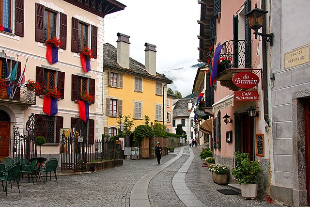
Santa Maria Maggiore
- Italian comune
Hiking in Santa Maria Maggiore
Santa Maria Maggiore, located in the scenic Vigezzo Valley of Piedmont, Italy, is an excellent destination for hiking enthusiasts. The area is characterized by its stunning landscapes, lush forests, charming villages, and the panoramic views of the surrounding mountains. Here are some key points about hiking in and around Santa Maria Maggiore:...
- Country:
- Postal Code: 28857
- Local Dialing Code: 0324
- Licence Plate Code: VB
- Coordinates: 46° 8' 0" N, 8° 28' 0" E
- GPS tracks (wikiloc): [Link]
- AboveSeaLevel: 1202 м m
- Area: 53.71 sq km
- Population: 1301
- Web site: [Link]
Trontano
- Italian comune
Hiking in Trontano
Trontano is a small village located in the Val Vigezzo region of Italy, known for its stunning landscapes and hiking opportunities. It’s nestled in the Piedmont region and is surrounded by the beautiful mountains of the Lepontine Alps. Here are some highlights of hiking in and around Trontano:...
- Country:
- Postal Code: 28859
- Local Dialing Code: 0324
- Licence Plate Code: VB
- Coordinates: 46° 5' 0" N, 8° 18' 0" E
- GPS tracks (wikiloc): [Link]
- AboveSeaLevel: 520 м m
- Area: 56.74 sq km
- Population: 1652
- Web site: [Link]