Maumusson (Maumusson)

- commune in Loire-Atlantique, France
- Country:

- Postal Code: 44540
- Coordinates: 47° 28' 58" N, 1° 6' 20" E


- GPS tracks (wikiloc): [Link]
- Area: 24.56 sq km
- Population: 1046
- Web site: http://www.pays-ancenis.fr/index.php?id=3962
- Wikipedia en: wiki(en)
- Wikipedia: wiki(fr)
- Wikidata storage: Wikidata: Q1114003
- Wikipedia Commons Category: [Link]
- Freebase ID: [/m/03nwd1d]
- Freebase ID: [/m/03nwd1d]
- GeoNames ID: Alt: [6449118]
- GeoNames ID: Alt: [6449118]
- SIREN number: [214400939]
- SIREN number: [214400939]
- BnF ID: [15260262j]
- BnF ID: [15260262j]
- VIAF ID: Alt: [238814911]
- VIAF ID: Alt: [238814911]
- INSEE municipality code: 44093
- INSEE municipality code: 44093
Shares border with regions:

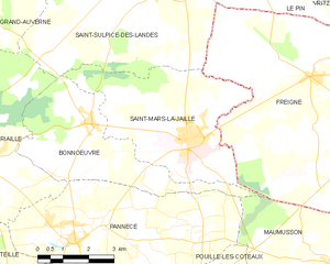
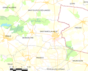
Saint-Mars-la-Jaille
- commune in Loire-Atlantique, France
- Country:
- Postal Code: 44540
- Coordinates: 47° 31' 31" N, 1° 11' 5" E
- GPS tracks (wikiloc): [Link]
- Area: 20.06 sq km
- Population: 2400
- Web site: [Link]

Bonnœuvre
- commune in Loire-Atlantique, France
- Country:
- Postal Code: 44540
- Coordinates: 47° 31' 39" N, 1° 14' 10" E
- GPS tracks (wikiloc): [Link]
- Area: 15.66 sq km
- Population: 560
- Web site: [Link]

Freigné
- commune in Maine-et-Loire, France
- Country:
- Postal Code: 49440
- Coordinates: 47° 32' 55" N, 1° 7' 20" E
- GPS tracks (wikiloc): [Link]
- Area: 65.26 sq km
- Population: 1131


La Roche-Blanche
- commune in Loire-Atlantique, France
- Country:
- Postal Code: 44522
- Coordinates: 47° 26' 27" N, 1° 8' 26" E
- GPS tracks (wikiloc): [Link]
- Area: 14.82 sq km
- Population: 1180
- Web site: [Link]


Pouillé-les-Côteaux
- commune in Loire-Atlantique, France
- Country:
- Postal Code: 44522
- Coordinates: 47° 27' 19" N, 1° 9' 44" E
- GPS tracks (wikiloc): [Link]
- Area: 11.72 sq km
- Population: 1000
- Web site: [Link]


Pannecé
- commune in Loire-Atlantique, France
- Country:
- Postal Code: 44440
- Coordinates: 47° 29' 10" N, 1° 14' 22" E
- GPS tracks (wikiloc): [Link]
- Area: 30.59 sq km
- Population: 1340
- Web site: [Link]


La Rouxière
- former commune in Loire-Atlantique, France
- Country:
- Postal Code: 44370
- Coordinates: 47° 26' 34" N, 1° 4' 4" E
- GPS tracks (wikiloc): [Link]
- Area: 20.96 sq km
- Population: 1130
- Web site: [Link]


Belligné
- former commune in Loire-Atlantique, France
- Country:
- Postal Code: 44370
- Coordinates: 47° 28' 3" N, 1° 1' 41" E
- GPS tracks (wikiloc): [Link]
- Area: 32.8 sq km
- Population: 1858
- Web site: [Link]