Mayres (Mayres)

- commune in Puy-de-Dôme, France
- Country:

- Postal Code: 63220
- Coordinates: 45° 23' 18" N, 3° 41' 42" E


- GPS tracks (wikiloc): [Link]
- Area: 12.49 sq km
- Population: 189
- Wikipedia en: wiki(en)
- Wikipedia: wiki(fr)
- Wikidata storage: Wikidata: Q270448
- Wikipedia Commons Category: [Link]
- Freebase ID: [/m/03qhbv6]
- GeoNames ID: Alt: [6440086]
- SIREN number: [216302182]
- BnF ID: [15269568m]
- INSEE municipality code: 63218
Shares border with regions:
Saint-Sauveur-la-Sagne
- commune in Puy-de-Dôme, France
- Country:
- Postal Code: 63220
- Coordinates: 45° 23' 41" N, 3° 40' 0" E
- GPS tracks (wikiloc): [Link]
- AboveSeaLevel: 814 м m
- Area: 7.74 sq km
- Population: 97

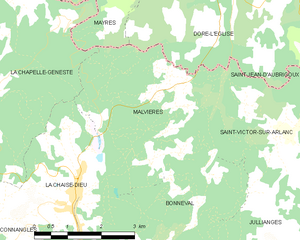
Malvières
- commune in Haute-Loire, France
- Country:
- Postal Code: 43160
- Coordinates: 45° 20' 14" N, 3° 43' 56" E
- GPS tracks (wikiloc): [Link]
- Area: 13.72 sq km
- Population: 137

Dore-l'Église
- commune in Puy-de-Dôme, France
- Country:
- Postal Code: 63220
- Coordinates: 45° 22' 59" N, 3° 45' 4" E
- GPS tracks (wikiloc): [Link]
- Area: 27.14 sq km
- Population: 627


Arlanc
- commune in Puy-de-Dôme, France
- Country:
- Postal Code: 63220
- Coordinates: 45° 24' 47" N, 3° 43' 28" E
- GPS tracks (wikiloc): [Link]
- Area: 32.19 sq km
- Population: 1907


Novacelles
- commune in Puy-de-Dôme, France
- Country:
- Postal Code: 63220
- Coordinates: 45° 26' 15" N, 3° 39' 0" E
- GPS tracks (wikiloc): [Link]
- Area: 14.43 sq km
- Population: 136
La Chapelle-Geneste
- commune in Haute-Loire, France
- Country:
- Postal Code: 43160
- Coordinates: 45° 20' 59" N, 3° 40' 3" E
- GPS tracks (wikiloc): [Link]
- Area: 18.06 sq km
- Population: 113