Melissano (Melissano)
.svg)
- Italian comune
 Hiking in Melissano
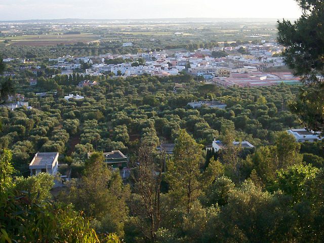
Melissano is a small town located in the province of Lecce, in the Apulia region of Italy. While it may not be widely known as a hiking destination, it offers access to beautiful landscapes, coastal areas, and the countryside of the Salento peninsula.
Hiking Opportunities around Melissano
-
Natural Parks and Reserves: The nearby Parco Naturale Regionale Costa Otranto – Santa Maria di Leuca e Bosco di Tricase offers stunning coastal views and diverse flora and fauna. You can find various trails that lead to cliffs, beaches, and picturesque villages.
-
Countryside Trails: The countryside around Melissano is dotted with olive groves, vineyards, and traditional dry stone walls. You can create a walking route that includes these scenic landscapes, giving you a taste of the region’s rural charm.
-
Coastal Hikes: A short drive from Melissano will take you to the Adriatic coast, where coastal trails offer breathtaking views. The routes along the coastline can range from easy walks to more challenging hikes with rocky terrains.
-
Nearby Towns: Explore the surrounding towns, such as Gallipoli and Otranto. Both locations offer paths that connect to the scenic coastal routes and historic sites, perfect for combining hiking with cultural experiences.
Tips for Hiking in Melissano
-
Best Time to Hike: The ideal time for hiking in this region is during the spring (April to June) and fall (September to October) when temperatures are milder and the landscapes are vibrant.
-
Gear Up: Wear comfortable hiking boots and bring plenty of water, sunscreen, and snacks, especially during warmer months.
-
Map & Navigation: While some trails may be well-marked, it’s a good idea to have a map or a GPS device, especially if venturing into less populated areas.
-
Respect Nature: Follow the Leave No Trace principles, respect wildlife, and stay on designated trails to protect the natural beauty of the region.
Melissano might not have the extensive hiking infrastructure of larger national parks, but its charm lies in the ability to explore serene landscapes and enjoy a quiet, authentic Italian experience. Happy hiking!
- Country:

- Postal Code: 73040
- Local Dialing Code: 0833
- Licence Plate Code: LE
- Coordinates: 39° 58' 0" N, 18° 8' 0" E


- GPS tracks (wikiloc): [Link]
- AboveSeaLevel: 59 м m
- Area: 12.55 sq km
- Population: 7129
- Web site: http://www.comunemelissano.le.it/
- Wikipedia en: wiki(en)
- Wikipedia: wiki(it)
- Wikidata storage: Wikidata: Q52158
- Wikipedia Commons Category: [Link]
- Freebase ID: [/m/0f_3r1]
- GeoNames ID: Alt: [6538976]
- VIAF ID: Alt: [235717932]
- OSM relation ID: [40179]
- Quora topic ID: [Melissano]
- UN/LOCODE: [ITME8]
- ISTAT ID: 075044
- Italian cadastre code: F109
Shares border with regions:

Casarano
- Italian comune
Hiking in Casarano
Casarano is a charming town located in the Apulia region of southern Italy, known for its picturesque landscapes, historical sites, and beautiful agricultural scenery. When considering hiking in and around Casarano, there are several aspects to keep in mind:...
- Country:
- Postal Code: 73042
- Local Dialing Code: 0833
- Licence Plate Code: LE
- Coordinates: 40° 1' 0" N, 18° 10' 0" E
- GPS tracks (wikiloc): [Link]
- AboveSeaLevel: 109 м m
- Area: 38.73 sq km
- Population: 20070
- Web site: [Link]

Matino
- Italian comune
Hiking in Matino
Matino, located in the Apulia region of Italy, is surrounded by beautiful landscapes and a rich natural environment that makes it a great destination for hiking enthusiasts. Here are some highlights to consider when hiking in and around Matino:...
- Country:
- Postal Code: 73046
- Local Dialing Code: 0833
- Licence Plate Code: LE
- Coordinates: 40° 2' 0" N, 18° 8' 0" E
- GPS tracks (wikiloc): [Link]
- AboveSeaLevel: 75 м m
- Area: 26.63 sq km
- Population: 11444
- Web site: [Link]

Racale
- Italian comune
Hiking in Racale
Racale, located in the Apulia region of Italy, is surrounded by beautiful natural landscapes that make it a great destination for hiking enthusiasts. The area features a mix of coastal trails, rural paths, and historical sites, giving hikers a diverse experience....
- Country:
- Postal Code: 73055
- Local Dialing Code: 0833
- Licence Plate Code: LE
- Coordinates: 39° 58' 0" N, 18° 6' 0" E
- GPS tracks (wikiloc): [Link]
- AboveSeaLevel: 55 м m
- Area: 24.29 sq km
- Population: 11011
- Web site: [Link]


Taviano
- Italian comune
Hiking in Taviano
Taviano is a charming town located in the Apulia region of southern Italy, close to the beautiful coastline of Salento. While Taviano itself may not be known as a major hiking destination, there are several opportunities in the surrounding area that offer breathtaking views and natural beauty....
- Country:
- Postal Code: 73057
- Local Dialing Code: 0833
- Licence Plate Code: LE
- Coordinates: 39° 58' 56" N, 18° 4' 53" E
- GPS tracks (wikiloc): [Link]
- AboveSeaLevel: 54 м m
- Area: 22.13 sq km
- Population: 11972
- Web site: [Link]


Ugento
- Italian comune
Hiking in Ugento
Ugento, located in the Apulia region of Italy, is known for its beautiful landscapes, rich history, and stunning coastal areas. Hiking in and around Ugento offers a unique blend of natural beauty and cultural experiences. Here are a few highlights to consider when planning a hiking trip in Ugento:...
- Country:
- Postal Code: 73059
- Local Dialing Code: 0833
- Licence Plate Code: LE
- Coordinates: 39° 56' 0" N, 18° 10' 0" E
- GPS tracks (wikiloc): [Link]
- AboveSeaLevel: 108 м m
- Area: 100.4 sq km
- Population: 12412
- Web site: [Link]