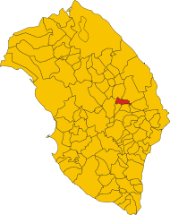
Melpignano (Melpignano)
.svg)
- Italian comune
 Hiking in Melpignano
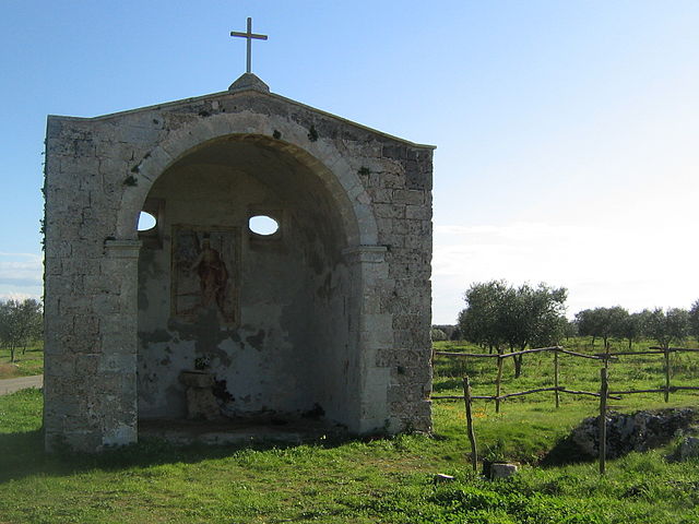
Melpignano, a charming town located in the Apulia region of Italy, is known for its stunning natural landscapes and rich cultural heritage. While Melpignano itself may not be primarily known as a hiking destination, it offers several opportunities for outdoor activities in its surrounding areas.
Hiking Opportunities in and Around Melpignano:
-
Natural Landscapes: The countryside around Melpignano features rolling hills, olive groves, and picturesque vineyards. You can explore these areas on foot, experiencing the local flora and fauna.
-
Salento: The region of Salento, where Melpignano is located, boasts beautiful coastal trails. The nearby Adriatic and Ionian coasts provide excellent opportunities for scenic hikes with breathtaking views of the sea.
-
The Coastal Path: Consider hiking along some of the coastal paths that meander through cliffs and beaches, offering stunning vistas. The Path of the Coastal Parks of Salento is a popular choice for its natural beauty.
-
Walking Tours: Melpignano itself often features guided walking tours that explore the town's history, architecture, and local culture, providing a unique blend of hiking and cultural appreciation.
-
Local Trails: Look for local trails that lead to nearby towns such as Maglie and Otranto, which can offer a mix of historical exploration and nature walking.
Tips for Hiking in Melpignano:
-
Weather Considerations: Check the weather before heading out, especially in summer, as it can get quite hot. Early mornings or late afternoons are great times for hiking.
-
Footwear: Wear comfortable, sturdy hiking shoes suitable for various terrains.
-
Hydration: Always carry enough water, especially on warmer days.
-
Navigation: While many paths are well-marked, having a map or GPS can help ensure you stay on course.
-
Respect Nature: Follow Leave No Trace principles to keep the area pristine for future hikers.
Nearby Attractions:
While in Melpignano, take the time to explore the local culture, try regional foods, and perhaps visit historic sites like the Church of Santa Maria di Costantinopoli or the famous Griko villages in the area.
Enjoy your hiking adventure in Melpignano and the beautiful Salento region!
- Country:

- Postal Code: 73020
- Local Dialing Code: 0836
- Licence Plate Code: LE
- Coordinates: 40° 9' 0" N, 18° 18' 0" E


- GPS tracks (wikiloc): [Link]
- AboveSeaLevel: 89 м m
- Area: 11.1 sq km
- Population: 2218
- Web site: http://www.comune.melpignano.le.it/
- Wikipedia en: wiki(en)
- Wikipedia: wiki(it)
- Wikidata storage: Wikidata: Q52159
- Wikipedia Commons Gallery: [Link]
- Wikipedia Commons Category: [Link]
- Freebase ID: [/m/03wkgn]
- GeoNames ID: Alt: [6540765]
- VIAF ID: Alt: [238110772]
- OSM relation ID: [40278]
- TGN ID: [7049973]
- UN/LOCODE: [ITMPG]
- ISTAT ID: 075045
- Italian cadastre code: F117
Shares border with regions:

Castrignano de' Greci
- Italian comune
Hiking in Castrignano de' Greci
Castrignano de' Greci is a small town located in the Apulia region of southern Italy, known for its charming historical architecture and beautiful natural surroundings. While it may not be as famous as some other hiking destinations in Italy, it offers some lovely opportunities for hiking enthusiasts....
- Country:
- Postal Code: 73020
- Local Dialing Code: 0836
- Licence Plate Code: LE
- Coordinates: 40° 12' 0" N, 18° 18' 0" E
- GPS tracks (wikiloc): [Link]
- AboveSeaLevel: 90 м m
- Area: 9.62 sq km
- Population: 3919
- Web site: [Link]


Corigliano d'Otranto
- Italian comune
Hiking in Corigliano d'Otranto
Corigliano d'Otranto, located in the province of Lecce in the Apulia region of Italy, offers a charming landscape that is perfect for hiking enthusiasts. While it may not be the first location that comes to mind for hiking, it does have unique features that attract nature lovers and adventurers alike....
- Country:
- Postal Code: 73022
- Local Dialing Code: 0836
- Licence Plate Code: LE
- Coordinates: 40° 10' 0" N, 18° 15' 0" E
- GPS tracks (wikiloc): [Link]
- AboveSeaLevel: 76 м m
- Area: 28.41 sq km
- Population: 5768
- Web site: [Link]


Cursi
- Italian comune
Hiking in Cursi
Cursi is a small town located in the Apulia region of Italy, known for its rich history and cultural heritage. While it may not be a primary hiking destination, the surrounding areas offer opportunities for outdoor activities and exploration....
- Country:
- Postal Code: 73020
- Local Dialing Code: 0836
- Licence Plate Code: LE
- Coordinates: 40° 9' 0" N, 18° 19' 0" E
- GPS tracks (wikiloc): [Link]
- AboveSeaLevel: 90 м m
- Area: 8.36 sq km
- Population: 4121
- Web site: [Link]

Cutrofiano
- Italian comune
Hiking in Cutrofiano
Cutrofiano is a charming town located in the Apulia region of Italy, known for its beautiful landscapes, historic architecture, and rich cultural heritage. While it may not be as famous for hiking as some other regions of Italy, there are still opportunities for outdoor enthusiasts to explore the countryside and enjoy nature....
- Country:
- Postal Code: 73020
- Local Dialing Code: 0836
- Licence Plate Code: LE
- Coordinates: 40° 8' 0" N, 18° 12' 0" E
- GPS tracks (wikiloc): [Link]
- AboveSeaLevel: 81 м m
- Area: 56.81 sq km
- Population: 8992
- Web site: [Link]


Maglie
- Italian comune
Hiking in Maglie
Maglie is a charming town located in the Apulia region of southern Italy, and while it's not as widely known for its hiking trails as other parts of the country, there are certainly opportunities to explore the stunning natural landscapes surrounding it. Here are some highlights to consider when hiking in and around Maglie:...
- Country:
- Postal Code: 73024
- Local Dialing Code: 0836
- Licence Plate Code: LE
- Coordinates: 40° 7' 0" N, 18° 18' 0" E
- GPS tracks (wikiloc): [Link]
- AboveSeaLevel: 81 м m
- Area: 22.66 sq km
- Population: 14196
- Web site: [Link]