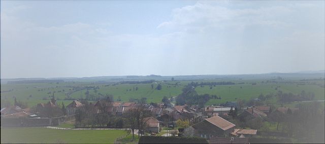
Merrey (Merrey)

- commune in Haute-Marne, France
- Country:

- Postal Code: 52240
- Coordinates: 48° 3' 17" N, 5° 35' 28" E


- GPS tracks (wikiloc): [Link]
- Area: 6.84 sq km
- Population: 109
- Wikipedia en: wiki(en)
- Wikipedia: wiki(fr)
- Wikidata storage: Wikidata: Q614744
- Wikipedia Commons Category: [Link]
- Freebase ID: [/m/03ntvf2]
- Freebase ID: [/m/03ntvf2]
- GeoNames ID: Alt: [6454276]
- GeoNames ID: Alt: [6454276]
- SIREN number: [215202318]
- SIREN number: [215202318]
- BnF ID: [15263567t]
- BnF ID: [15263567t]
- INSEE municipality code: 52320
- INSEE municipality code: 52320
Shares border with regions:


Val-de-Meuse
- commune in Haute-Marne, France
- Country:
- Postal Code: 52140
- Coordinates: 47° 59' 59" N, 5° 29' 54" E
- GPS tracks (wikiloc): [Link]
- AboveSeaLevel: 420 м m
- Area: 77.48 sq km
- Population: 1888
- Web site: [Link]
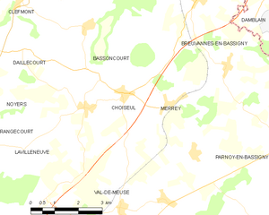
Choiseul
- commune in Haute-Marne, France
- Country:
- Postal Code: 52240
- Coordinates: 48° 3' 31" N, 5° 34' 3" E
- GPS tracks (wikiloc): [Link]
- Area: 8.63 sq km
- Population: 80

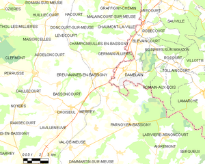
Breuvannes-en-Bassigny
- commune in Haute-Marne, France
- Country:
- Postal Code: 52240
- Coordinates: 48° 5' 37" N, 5° 36' 31" E
- GPS tracks (wikiloc): [Link]
- AboveSeaLevel: 326 м m
- Area: 48.55 sq km
- Population: 687