Mignano Monte Lungo (Mignano Monte Lungo)
.svg)
- Italian comune
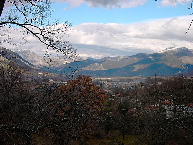
 Hiking in Mignano Monte Lungo
Mignano Monte Lungo, located in the Lazio region of Italy, is a hidden gem for hiking enthusiasts. This small town is nestled in the hills of the Aurunci Mountains and offers stunning natural landscapes, rich history, and a variety of hiking trails suitable for different skill levels.
Hiking Trails
-
Sentiero delle Leggende:
- This trail is designed to showcase the myths and legends of the area. It's a relatively easy hike, ideal for families and those looking to enjoy nature without too much difficulty. The path winds through scenic woodlands and offers beautiful views of the surrounding landscape.
-
Monte Lungo Trail:
- For more experienced hikers, the trail leading to Monte Lungo is a rewarding challenge. The ascent provides panoramic views of the valleys below and, on clear days, you can see as far as the Tyrrhenian Sea.
-
Piana delle Orme:
- This area features a network of trails that connect to historical sites. You can explore old ruins and learn about the area's history while enjoying the natural beauty of the region.
Tips for Hiking in Mignano Monte Lungo
-
Best Time to Visit: The ideal months for hiking are typically late spring (May and June) and early autumn (September and October) when the weather is mild.
-
Gear: Wear sturdy hiking boots, bring plenty of water, and have appropriate clothing for changing weather conditions. A map or GPS device can also be helpful since trails may not always be clearly marked.
-
Respect Nature: Practice Leave No Trace principles by staying on designated trails and disposing of waste properly.
-
Local Cuisine: After a day of hiking, don't miss the chance to enjoy local cuisine in Mignano Monte Lungo, such as pasta dishes, meats, and local wines.
Safety Considerations
- Check the weather forecast before your hike and be prepared for sudden changes.
- Let someone know your hiking plans, especially if you plan to tackle more remote trails.
- Consider hiking with a guide or a group if you're unfamiliar with the area.
Hiking in Mignano Monte Lungo provides a combination of adventure, natural beauty, and a touch of local culture, making it a fantastic choice for outdoor enthusiasts searching for a unique experience in Italy.
- Country:

- Postal Code: 81049
- Local Dialing Code: 0823
- Licence Plate Code: CE
- Coordinates: 41° 24' 0" N, 13° 59' 0" E


- GPS tracks (wikiloc): [Link]
- AboveSeaLevel: 137 м m
- Area: 53.1 sq km
- Population: 3160
- Web site: http://www.comune.mignanomontelungo.ce.it
- Wikipedia en: wiki(en)
- Wikipedia: wiki(it)
- Wikidata storage: Wikidata: Q58714
- Wikipedia Commons Category: [Link]
- Freebase ID: [/m/0gmzx2]
- GeoNames ID: Alt: [6542109]
- OSM relation ID: [41261]
- UN/LOCODE: [ITZNN]
- Digital Atlas of the Roman Empire ID: [29138]
- ISTAT ID: 061051
- Italian cadastre code: F203
Shares border with regions:
San Vittore del Lazio
- Italian comune
Hiking in San Vittore del Lazio
San Vittore del Lazio is a charming town located in the province of Frosinone, in the Lazio region of Italy. It is surrounded by beautiful natural landscapes, making it an attractive destination for hiking enthusiasts. Here are some highlights and tips for hiking in and around San Vittore del Lazio:...
- Country:
- Postal Code: 03040
- Local Dialing Code: 0776
- Licence Plate Code: FR
- Coordinates: 41° 28' 0" N, 13° 56' 0" E
- GPS tracks (wikiloc): [Link]
- AboveSeaLevel: 210 м m
- Area: 27.51 sq km
- Population: 2571
- Web site: [Link]


Sesto Campano
- Italian comune
Hiking in Sesto Campano
Sesto Campano is a small town located in the province of Isernia in the Molise region of Italy. Nestled in the Apennine Mountains, it offers a variety of hiking opportunities that showcase its natural beauty and rich cultural heritage....
- Country:
- Postal Code: 86078
- Local Dialing Code: 0865
- Licence Plate Code: IS
- Coordinates: 41° 25' 0" N, 14° 5' 0" E
- GPS tracks (wikiloc): [Link]
- AboveSeaLevel: 323 м m
- Area: 35.32 sq km
- Population: 2313
- Web site: [Link]


Venafro
- Italian comune
Hiking in Venafro
Venafro, located in the Molise region of Italy, offers a variety of hiking opportunities for outdoor enthusiasts. The area is characterized by its beautiful landscapes, rich history, and diverse flora and fauna. Here are some highlights and tips for hiking in Venafro:...
- Country:
- Postal Code: 86079
- Local Dialing Code: 0865
- Licence Plate Code: IS
- Coordinates: 41° 29' 0" N, 14° 3' 0" E
- GPS tracks (wikiloc): [Link]
- AboveSeaLevel: 222 м m
- Area: 46.45 sq km
- Population: 11209
- Web site: [Link]

Conca della Campania
- Italian comune
Hiking in Conca della Campania
Conca della Campania is a small town in the province of Caserta, located in the Campania region of Italy. Nestled at the foot of the Matese Mountains, it offers a variety of hiking opportunities amid picturesque landscapes, lush forests, and rich historical sights....
- Country:
- Postal Code: 81044
- Local Dialing Code: 0823
- Licence Plate Code: CE
- Coordinates: 41° 20' 0" N, 13° 59' 0" E
- GPS tracks (wikiloc): [Link]
- AboveSeaLevel: 420 м m
- Area: 26.47 sq km
- Population: 1196
- Web site: [Link]
Galluccio
- Italian comune
Hiking in Galluccio
Galluccio, located in the province of Caserta in the Campania region of Italy, offers a beautiful setting for hiking enthusiasts. Nestled within the picturesque landscape of the Aurunci Mountains, the area is known for its diverse terrain, rich vegetation, and stunning views. Here are some highlights to consider when hiking in Galluccio:...
- Country:
- Postal Code: 81044
- Local Dialing Code: 0823
- Licence Plate Code: CE
- Coordinates: 41° 21' 0" N, 13° 57' 0" E
- GPS tracks (wikiloc): [Link]
- AboveSeaLevel: 368 м m
- Area: 32.11 sq km
- Population: 2152
- Web site: [Link]
Presenzano
- Italian comune
Hiking in Presenzano
Presenzano, a charming town in the province of Caserta in the Campania region of Italy, offers a variety of hiking opportunities for both beginners and experienced trekkers. Here are some highlights:...
- Country:
- Postal Code: 81050
- Local Dialing Code: 0823
- Licence Plate Code: CE
- Coordinates: 41° 23' 0" N, 14° 5' 0" E
- GPS tracks (wikiloc): [Link]
- AboveSeaLevel: 350 м m
- Area: 31.89 sq km
- Population: 1778
- Web site: [Link]
Rocca d'Evandro
- Italian comune
Hiking in Rocca d'Evandro
Rocca d'Evandro is a picturesque town located in the province of Caserta in southern Italy. Nestled in the foothills of the Matese Mountains, it offers a range of hiking opportunities for both novice and experienced hikers. Here are some key points to consider if you're planning to hike in this area:...
- Country:
- Postal Code: 81040
- Local Dialing Code: 0823
- Licence Plate Code: CE
- Coordinates: 41° 23' 0" N, 13° 53' 0" E
- GPS tracks (wikiloc): [Link]
- AboveSeaLevel: 83 м m
- Area: 49.54 sq km
- Population: 3178
- Web site: [Link]

San Pietro Infine
- Italian comune
Hiking in San Pietro Infine
San Pietro Infine is a picturesque village located in the province of Caserta, in the Campania region of Italy. Nestled in the foothills of the Matese mountains, it offers a range of hiking opportunities that appeal to both casual walkers and more serious hikers....
- Country:
- Postal Code: 81049
- Local Dialing Code: 0823
- Licence Plate Code: CE
- Coordinates: 41° 26' 49" N, 13° 57' 45" E
- GPS tracks (wikiloc): [Link]
- AboveSeaLevel: 140 м m
- Area: 13.72 sq km
- Population: 1025
- Web site: [Link]