Misery (Misery)

- commune in Somme, France
- Country:

- Postal Code: 80320
- Coordinates: 49° 50' 56" N, 2° 53' 11" E


- GPS tracks (wikiloc): [Link]
- Area: 3.28 sq km
- Population: 128
- Wikipedia en: wiki(en)
- Wikipedia: wiki(fr)
- Wikidata storage: Wikidata: Q379446
- Wikipedia Commons Category: [Link]
- Freebase ID: [/m/03qms1z]
- GeoNames ID: Alt: [6444624]
- SIREN number: [218005221]
- BnF ID: [15277028q]
- INSEE municipality code: 80551
Shares border with regions:

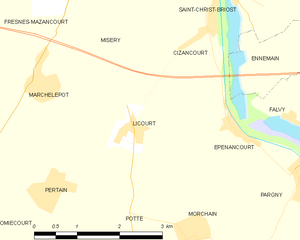
Licourt
- commune in Somme, France
- Country:
- Postal Code: 80320
- Coordinates: 49° 49' 29" N, 2° 53' 40" E
- GPS tracks (wikiloc): [Link]
- Area: 6.93 sq km
- Population: 395


Saint-Christ-Briost
- commune in Somme, France
- Country:
- Postal Code: 80200
- Coordinates: 49° 51' 14" N, 2° 55' 47" E
- GPS tracks (wikiloc): [Link]
- Area: 7.82 sq km
- Population: 438

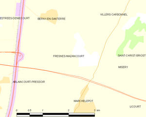
Fresnes-Mazancourt
- commune in Somme, France
- Country:
- Postal Code: 80320
- Coordinates: 49° 51' 6" N, 2° 51' 55" E
- GPS tracks (wikiloc): [Link]
- Area: 5.7 sq km
- Population: 135

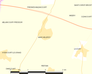
Marchélepot
- commune in Somme, France
- Country:
- Postal Code: 80200
- Coordinates: 49° 50' 4" N, 2° 51' 57" E
- GPS tracks (wikiloc): [Link]
- Area: 5.27 sq km
- Population: 470


Villers-Carbonnel
- commune in Somme, France
- Country:
- Postal Code: 80200
- Coordinates: 49° 52' 35" N, 2° 53' 48" E
- GPS tracks (wikiloc): [Link]
- Area: 7.66 sq km
- Population: 342