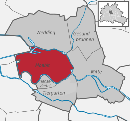
Moabit (Moabit)
- locality of Berlin
Moabit is a neighborhood in Berlin, Germany, that is known more for its urban landscape than for traditional hiking. However, there are plenty of opportunities for enjoyable walks and exploring green spaces in the area. Here are some suggestions for exploring the outdoors in and around Moabit:
-
Parks and Green Spaces:
- Tiergarten: This large park is close to Moabit and offers extensive walking paths, beautiful gardens, and scenic spots. It’s perfect for a leisurely hike or a picnic.
- Plötzensee: Located a bit to the north, this lake features beautiful walking trails and spots for swimming, making it a nice destination for a day out.
-
Waterway Walks:
- Moabit is situated along the Spree River and the Westhafen Canal, so you can explore the waterfront pathways. Walking along these waterways provides a peaceful ambiance with views of the city and local wildlife.
-
Hiking Trails Nearby:
- For more traditional hiking experiences, you may need to venture a bit outside of the city. The surrounding Brandenburg region offers a variety of trails and nature reserves, such as the Müggelsee area or the forests around Grunewald.
-
Historical Walks:
- Moabit is rich in history, so consider a walking tour that includes historical sites, including the local architecture, such as the infamous Moabit prison, and murals reflecting the city’s diverse culture.
-
Cultural Hikes:
- Combine your hiking with cultural experiences by visiting local galleries, cafes, and restaurants along your route. Moabit has a vibrant culinary scene worth exploring.
When hiking in and around urban areas, always remember to stay hydrated, wear comfortable footwear, and be aware of your surroundings. Whether you prefer leisurely walks in parks or exploring the city, Moabit offers a unique blend of urban exploration and nature.
- Country:

- Postal Code: 13353; 10559; 10557; 10555; 10553; 10551
- Coordinates: 52° 32' 0" N, 13° 20' 0" E


- GPS tracks (wikiloc): [Link]
- AboveSeaLevel: 40 м m
- Area: 7.72 sq km
- Population: 77344
- Wikipedia en: wiki(en)
- Wikipedia: wiki(de)
- Wikidata storage: Wikidata: Q699800
- Wikipedia Commons Gallery: [Link]
- Wikipedia Commons Category: [Link]
- Wikipedia Commons Maps Category: [Link]
- Freebase ID: [/m/02rhb7]
- GeoNames ID: Alt: [2870310]
- VIAF ID: Alt: [158239510]
- OSM relation ID: [28339]
- GND ID: Alt: [4087332-8]
- archINFORM location ID: [43326]
- Library of Congress authority ID: Alt: [n00024838]
- Quora topic ID: [Moabit]
Shares border with regions:


Charlottenburg
- locality of Berlin, Germany
Charlottenburg, a district in Berlin, is more urban and built-up than natural hiking locations, but it still offers opportunities for outdoor activities and leisurely walks. Here are some suggestions for enjoying the outdoors in and around Charlottenburg:...
- Country:

- Postal Code: 14059; 14057; 14055; 14052; 10629; 10627; 10625; 10623; 10589; 10587; 10585
- Coordinates: 52° 31' 0" N, 13° 18' 0" E


- GPS tracks (wikiloc): [Link]
- AboveSeaLevel: 46 м m
- Area: 10.6 sq km
- Population: 124555


Mitte
- locality in the borough of Mitte, Berlin, Germany
Mitte is the central borough of Berlin, Germany, and while it is primarily an urban area known for its historical sites, museums, and vibrant culture, there are still opportunities for outdoor activities, including hiking, especially if you're willing to explore nearby green spaces and parks....
- Country:

- Postal Code: 10179; 10178; 10119; 10117; 10115
- Licence Plate Code: B
- Coordinates: 52° 31' 10" N, 13° 24' 24" E


- GPS tracks (wikiloc): [Link]
- AboveSeaLevel: 48 м m
- Area: 10.69 sq km
- Population: 89757


Tiergarten
- locality in the borough of Mitte, Berlin
Tiergarten is one of the largest and most popular urban parks in Berlin, Germany, and it's a great spot for hiking and outdoor activities. While it's not a traditional hiking destination with rugged trails, it offers an extensive network of paths suitable for leisurely walks, jogging, cycling, and enjoying nature within the city....
- Country:

- Postal Code: 10787; 10785; 10557
- Coordinates: 52° 31' 0" N, 13° 22' 0" E


- GPS tracks (wikiloc): [Link]
- Area: 5.17 sq km
- Population: 13934


Hansa quarter
- locality of Berlin
Hansaviertel, located in Berlin, is primarily known for its residential architecture and urban park landscapes rather than traditional hiking trails. However, there are some excellent spots for walking and enjoying the outdoors. Here are some activities you can consider:...
- Country:

- Postal Code: 10557; 10555
- Coordinates: 52° 31' 0" N, 13° 20' 20" E


- GPS tracks (wikiloc): [Link]
- AboveSeaLevel: 38 м m
- Area: 0.53 sq km
- Population: 5689


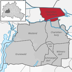
Charlottenburg-Nord
- locality of Berlin
Charlottenburg-Nord, located in Berlin, Germany, is primarily an urban area; however, it does offer some opportunities for outdoor activities, including hiking. While it's not known for extensive wilderness trails, you can find some pleasant green spaces and parks where you can enjoy a walk or a leisurely hike....
- Country:

- Postal Code: 13627
- Coordinates: 52° 32' 20" N, 13° 17' 35" E


- GPS tracks (wikiloc): [Link]
- AboveSeaLevel: 28 м m
- Area: 6.20 sq km
- Population: 18856


Wedding
- locality in the borough of Mitte, Berlin, Germany
Hiking in Wedding, a district in the borough of Mitte, Berlin, might not be the first thing that comes to mind when you think of hiking, as it is primarily an urban area. However, there are several parks and green spaces within and around Wedding where you can enjoy short hikes or leisurely walks....
- Country:

- Postal Code: 13407; 13359; 13357; 13353; 13351; 13349; 13347
- Coordinates: 52° 33' 0" N, 13° 22' 0" E


- GPS tracks (wikiloc): [Link]
- AboveSeaLevel: 41 м m
- Area: 9.23 sq km
- Population: 83612


