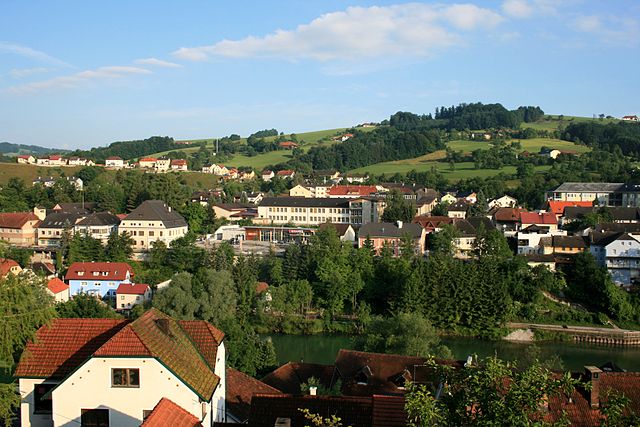
Molln (Molln)
- municipality in Austria
 Hiking in Molln
Molln, located in the beautiful Salzkammergut region of Austria, is known for its stunning Alpine landscapes and a variety of hiking opportunities. Here’s a guide to hiking in Molln:
Trails and Routes
-
Blick in die Berge:
- This circular trail offers spectacular views of the surrounding mountains. It’s suitable for families and less experienced hikers, making it a great way to enjoy the scenery without strenuous climbing.
-
Gesäuse National Park Trails:
- Nearby Molln, this national park has numerous trails ranging from easy to challenging. The park is renowned for its rugged beauty, featuring dramatic rock formations and the Enns River.
-
Schwarzensee Trail:
- A moderate hike leading to the beautiful Schwarzensee (Black Lake). The trail provides a serene setting with opportunities for birdwatching and photography.
-
Breitenauerau - Rothschildweg:
- This is a longer, scenic route that takes you through meadows and forests, ideal for those looking to immerse themselves in nature.
Hiking Tips
-
Seasonal Considerations: The best time to hike in Molln is during the warmer months (May to October). However, always check local weather conditions, as it can change rapidly in the mountains.
-
Gear: Always wear sturdy hiking boots and dress in layers. Carry a map, plenty of water, snacks, and a first-aid kit.
-
Safety: Inform someone about your hiking plans and expected return time. Mobile reception can be spotty in some areas.
-
Leave No Trace: Follow the principles of Leave No Trace to protect the pristine environment of Molln and its surroundings.
Local Attractions
-
Molln Village: The local village itself is charming, with traditional architecture and local eateries. Be sure to try some regional cuisine after your hike.
-
Cultural Sites: Explore nearby historical sites and cultural landmarks, which can provide a fascinating insight into the region's heritage.
With its stunning vistas, diverse trails, and natural beauty, Molln is a fantastic destination for hikers of all levels!
- Country:

- Postal Code: 4591
- Local Dialing Code: 07584
- Licence Plate Code: KI
- Coordinates: 47° 53' 1" N, 14° 15' 32" E


- GPS tracks (wikiloc): [Link]
- AboveSeaLevel: 442 м m
- Area: 191.4 sq km
- Population: 3653
- Web site: http://www.molln.at/
- Wikipedia en: wiki(en)
- Wikipedia: wiki(de)
- Wikidata storage: Wikidata: Q684847
- Wikipedia Commons Gallery: [Link]
- Wikipedia Commons Category: [Link]
- Freebase ID: [/m/03gq9w_]
- GeoNames ID: Alt: [2771299]
- VIAF ID: Alt: [145857607]
- GND ID: Alt: [4115184-7]
- archINFORM location ID: [10664]
- Library of Congress authority ID: Alt: [nr94024779]
- MusicBrainz area ID: [ee4b0849-06c3-407d-b399-32fe6cd3755b]
- WOEID: [545936]
- Austrian municipality key: [40909]
Shares border with regions:

Reichraming
- municipality in Austria
Hiking in Reichraming
Reichraming, located in Upper Austria, is an excellent destination for hiking enthusiasts. Nestled in the beautiful Salzatal valley and surrounded by stunning mountainous landscapes, the area offers a variety of trails suited for different skill levels, from leisurely walks to more challenging hikes....
- Country:
- Postal Code: 4462
- Local Dialing Code: 07255
- Licence Plate Code: SE
- Coordinates: 47° 53' 26" N, 14° 27' 44" E
- GPS tracks (wikiloc): [Link]
- AboveSeaLevel: 356 м m
- Area: 102 sq km
- Population: 1742
- Web site: [Link]


Rosenau am Hengstpaß
- municipality in Austria
Hiking in Rosenau am Hengstpaß
Rosenau am Hengstpass is a beautiful area in Austria, offering a range of hiking opportunities amidst stunning natural scenery. Nestled in the foothills of the Alps, the region is characterized by lush forests, alpine meadows, and panoramic views. Here are some key points to consider for hiking in this area:...
- Country:
- Postal Code: 4581
- Local Dialing Code: 07566
- Licence Plate Code: KI
- Coordinates: 47° 42' 49" N, 14° 23' 46" E
- GPS tracks (wikiloc): [Link]
- AboveSeaLevel: 700 м m
- Area: 108.3 sq km
- Population: 663
- Web site: [Link]


Klaus an der Pyhrnbahn
- municipality in Austria
Hiking in Klaus an der Pyhrnbahn
Klaus an der Pyhrnbahn is a picturesque village located in the Upper Austria region, surrounded by stunning natural landscapes, making it an excellent destination for hiking enthusiasts. Here are some key points about hiking in this area:...
- Country:
- Postal Code: 4564
- Local Dialing Code: 07585
- Licence Plate Code: KI
- Coordinates: 47° 49' 50" N, 14° 9' 29" E
- GPS tracks (wikiloc): [Link]
- AboveSeaLevel: 466 м m
- Area: 108 sq km
- Population: 1063
- Web site: [Link]
Grünburg
- municipality in Austria
Hiking in Grünburg
Grünburg, located in the scenic region of Upper Austria, is an excellent destination for hiking enthusiasts. It boasts beautiful natural landscapes, including lush forests, rolling hills, and stunning views of the surrounding mountains....
- Country:
- Licence Plate Code: KI
- Coordinates: 47° 58' 19" N, 14° 16' 40" E
- GPS tracks (wikiloc): [Link]
- AboveSeaLevel: 365 м m
- Area: 43.2 sq km
- Population: 3840
- Web site: [Link]


Ternberg
- municipality in Austria
Hiking in Ternberg
Ternberg, a charming village in Austria's Upper Austria region, offers a variety of hiking opportunities set against picturesque landscapes, rolling hills, and lush forests. Here are some key points about hiking in Ternberg:...
- Country:
- Local Dialing Code: 07256
- Licence Plate Code: SE
- Coordinates: 47° 56' 47" N, 14° 21' 27" E
- GPS tracks (wikiloc): [Link]
- AboveSeaLevel: 341 м m
- Area: 62 sq km
- Population: 3367
- Web site: [Link]
Sankt Pankraz
- municipality in Austria
Hiking in Sankt Pankraz
Sankt Pankraz, located in the heart of Austria, is an excellent destination for hiking enthusiasts. Nestled in the scenic landscape of Lower Austria, the area offers a diverse range of trails that cater to various skill levels, from beginners to seasoned hikers. Here are some highlights and tips for hiking in Sankt Pankraz:...
- Country:
- Postal Code: 4572
- Local Dialing Code: 07565
- Licence Plate Code: KI
- Coordinates: 47° 45' 54" N, 14° 12' 34" E
- GPS tracks (wikiloc): [Link]
- AboveSeaLevel: 531 м m
- Area: 47.1 sq km
- Population: 362
- Web site: [Link]

Roßleithen
- municipality in Austria
Hiking in Roßleithen
Roßleithen, located in the beautiful Salzkammergut region of Austria, offers a variety of hiking options for outdoor enthusiasts of all levels. The area is characterized by stunning landscapes, rolling hills, and panoramic views of the surrounding mountains, making it a great destination for both leisurely walks and more challenging hikes....
- Country:
- Postal Code: 4575
- Local Dialing Code: 07562
- Licence Plate Code: KI
- Coordinates: 47° 43' 29" N, 14° 18' 36" E
- GPS tracks (wikiloc): [Link]
- AboveSeaLevel: 588 м m
- Area: 67.5 sq km
- Population: 1889
- Web site: [Link]

Steinbach an der Steyr
- municipality in Austria
Hiking in Steinbach an der Steyr
Steinbach an der Steyr is a picturesque village situated in the Upper Austria region, known for its beautiful landscapes and access to outdoor activities, including hiking. The area is characterized by its stunning natural scenery, including rolling hills, the Steyr River, and lush forests, making it an ideal destination for hikers of all levels....
- Country:
- Postal Code: 4596
- Local Dialing Code: 07257
- Licence Plate Code: KI
- Coordinates: 47° 58' 16" N, 14° 16' 1" E
- GPS tracks (wikiloc): [Link]
- AboveSeaLevel: 381 м m
- Area: 28.2 sq km
- Population: 2009
- Web site: [Link]