Moncoutant (Moncoutant)

- commune in Deux-Sèvres, France
- Country:

- Postal Code: 79320
- Coordinates: 46° 43' 26" N, 0° 35' 20" E


- GPS tracks (wikiloc): [Link]
- Area: 26.32 sq km
- Population: 3161
- Web site: http://www.moncoutant.fr
- Wikipedia en: wiki(en)
- Wikipedia: wiki(fr)
- Wikidata storage: Wikidata: Q735945
- Wikipedia Commons Category: [Link]
- Freebase ID: [/m/03mg37f]
- GeoNames ID: Alt: [2993375]
- SIREN number: [217901792]
- BnF ID: [15276314m]
- VIAF ID: Alt: [239173328]
- WOEID: [611905]
- INSEE municipality code: 79179
Shares border with regions:
Courlay
- commune in Deux-Sèvres, France
- Country:
- Postal Code: 79440
- Coordinates: 46° 46' 46" N, 0° 34' 1" E
- GPS tracks (wikiloc): [Link]
- Area: 29.46 sq km
- Population: 2463
Le Breuil-Bernard
- commune in Deux-Sèvres, France
- Country:
- Postal Code: 79320
- Coordinates: 46° 43' 9" N, 0° 33' 12" E
- GPS tracks (wikiloc): [Link]
- Area: 8.25 sq km
- Population: 513
Saint-Jouin-de-Milly
- commune in Deux-Sèvres, France
- Country:
- Postal Code: 79380
- Coordinates: 46° 45' 16" N, 0° 37' 16" E
- GPS tracks (wikiloc): [Link]
- Area: 6.77 sq km
- Population: 190
Pugny
- commune in Deux-Sèvres, France
- Country:
- Postal Code: 79320
- Coordinates: 46° 43' 38" N, 0° 31' 26" E
- GPS tracks (wikiloc): [Link]
- Area: 6.99 sq km
- Population: 228

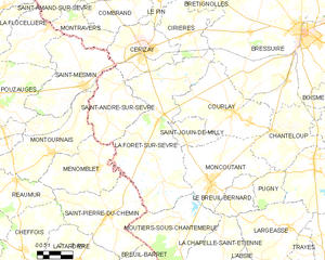
La Forêt-sur-Sèvre
- commune in Deux-Sèvres, France
- Country:
- Postal Code: 79380
- Coordinates: 46° 46' 12" N, 0° 38' 59" E
- GPS tracks (wikiloc): [Link]
- Area: 55.94 sq km
- Population: 2345
Moutiers-sous-Chantemerle
- commune in Deux-Sèvres, France
- Country:
- Postal Code: 79320
- Coordinates: 46° 41' 44" N, 0° 37' 6" E
- GPS tracks (wikiloc): [Link]
- Area: 25.64 sq km
- Population: 608
Chanteloup
- commune in Deux-Sèvres, France
- Country:
- Postal Code: 79320
- Coordinates: 46° 45' 59" N, 0° 31' 27" E
- GPS tracks (wikiloc): [Link]
- Area: 20.71 sq km
- Population: 1008