Courlay (Courlay)

- commune in Deux-Sèvres, France
- Country:

- Postal Code: 79440
- Coordinates: 46° 46' 46" N, 0° 34' 1" E


- GPS tracks (wikiloc): [Link]
- Area: 29.46 sq km
- Population: 2463
- Wikipedia en: wiki(en)
- Wikipedia: wiki(fr)
- Wikidata storage: Wikidata: Q1146377
- Wikipedia Commons Category: [Link]
- Freebase ID: [/m/03mg2hc]
- GeoNames ID: Alt: [6444107]
- SIREN number: [217901032]
- BnF ID: [15276238b]
- INSEE municipality code: 79103
Shares border with regions:
Saint-Jouin-de-Milly
- commune in Deux-Sèvres, France
- Country:
- Postal Code: 79380
- Coordinates: 46° 45' 16" N, 0° 37' 16" E
- GPS tracks (wikiloc): [Link]
- Area: 6.77 sq km
- Population: 190

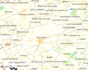
Bressuire
- commune in Deux-Sèvres, France
- Country:
- Postal Code: 79300
- Coordinates: 46° 50' 24" N, 0° 29' 19" E
- GPS tracks (wikiloc): [Link]
- AboveSeaLevel: 166 м m
- Area: 180.59 sq km
- Population: 19411
- Web site: [Link]

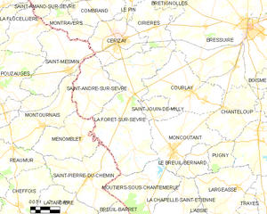
La Forêt-sur-Sèvre
- commune in Deux-Sèvres, France
- Country:
- Postal Code: 79380
- Coordinates: 46° 46' 12" N, 0° 38' 59" E
- GPS tracks (wikiloc): [Link]
- Area: 55.94 sq km
- Population: 2345

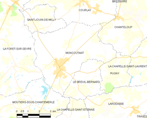
Moncoutant
- commune in Deux-Sèvres, France
- Country:
- Postal Code: 79320
- Coordinates: 46° 43' 26" N, 0° 35' 20" E
- GPS tracks (wikiloc): [Link]
- Area: 26.32 sq km
- Population: 3161
- Web site: [Link]
Chanteloup
- commune in Deux-Sèvres, France
- Country:
- Postal Code: 79320
- Coordinates: 46° 45' 59" N, 0° 31' 27" E
- GPS tracks (wikiloc): [Link]
- Area: 20.71 sq km
- Population: 1008